|
As autumn began I decided to make an arctic road trip, returning to Norway, one of my favourite countries, and heading further north than on any of my previous travels. I had initially planned this as just a Lofoten trip but I was able to leave a few days earlier in order to spend some time in the Senja area which is just to the south of Tromsø in the far north of Norway. My route took me north through almost the entire length of Finland before crossing to Norway near to Kilpisjärvi and heading to my accomodation at Hamn i Senja. At the northern extremes it is possible to cross directly from Finland to Norway, missing out Sweden entirely. The 1430km journey took about 17 hours of driving time. 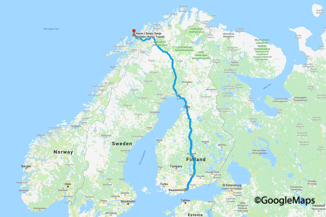 my journey north, shown in Google Maps The journey was not a difficult one at this time of year (mid-September) with the temperatures above zero and the roads in good condition. The main hazard was provided by the reindeer which became an increasingly common site after crossing the Arctic Circle at around the half way point of the journey. The terrain was made more beautiful by the autumn colours, at the cost of providing better camouflage for any large mammals that might loiter near the margins of the highway. Slowing down, or stopping completely, was required on 6 or 7 occasions to ensure safe passage for car and for animal. Eventually I arrived at Hamn i Senja sometime after dark. 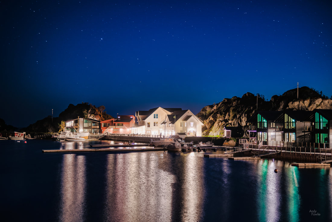 a first look at Hamn i Senja One major attraction of being so far north in such a sparsely populated area is the greatly enhanced possibilities to see the northern lights, aurora borealis. If you have not spent your time chasing the northern lights before then you might not know that there is an aurora forecast that you can follow, based on geomagnetic activity. This forecast is expressed as a number (between 0 and 9) known as the Kp index. The "normal" level of activity ranges from Kp 1-4 with 5 or higher indicating increasing levels of geomagnetic storm. The further north you are (south in the case of the southern lights, aurora australis) the more likely you are to be able to see auroras. In order to have a good chance of seeing auroras in France or Germany you would need an exceptional Kp index of 8 or 9, whereas from the north of Scotland or the south of Finland you have possibilities when the Kp index is around 5 (maybe once or twice per month). Hamn i Senja, at a latitude of nearly 69.5 degrees, is in the zone where a Kp index of 1 or 2 already brings aurora opportunities, hugely increasing your chances to see those magical lights. 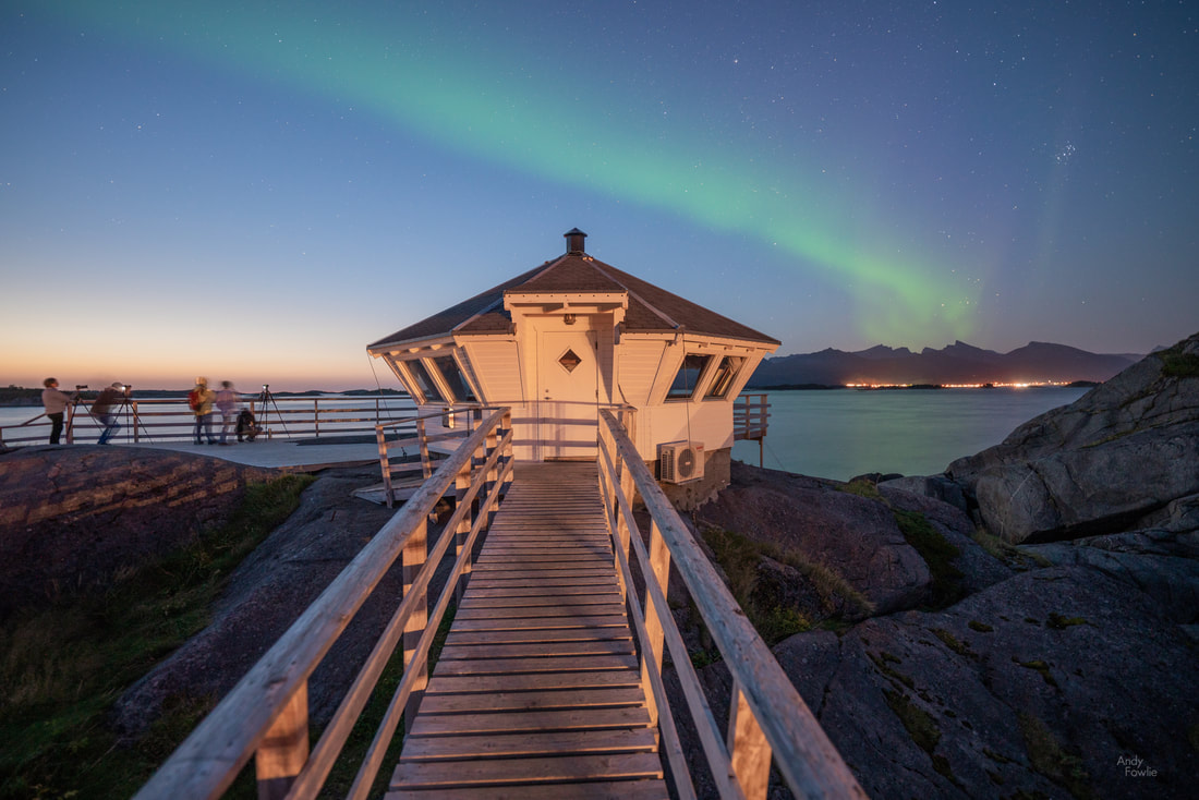 aurora watching is already under way before the glow of the sunset leaves the horizon Although I was a bit tired from my drive, I never like to pass up an aurora opportunity, so out I went, happy to find that the auroras were already dancing across the sky. Aurora photography is something of a challenge, and it pays to have done it a few times before. It is such a stunning sight when you first see bright and well defined auroras in the sky, the associated excitement and feeling of wonder easily leads to pointing your camera at the auroras without any regard for how you compose the frame overall - leading to ratehr poor pictures which just happen to have some green lights in them. It pays off to think of auroras as an enhancement for a composition which would work without them. Usually I like to scout for a few possible aurora enhanced composiitons during the day to be prepared for whatever happens in the evening, but on this occasion I had just arrived so I had no idea where would be best. I decided to just see what I could do with the immediate area of my hotel rather than searching randomly in the dark for new places. 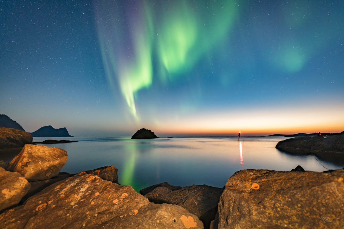 auroras reach down to a rocky island in the Atlantic Eventually I tore myself away from the show and got some much needed sleep. At this time of year the shooting schedule is quite demanding as ideally you need to be in position for sunrise (before 0600), sunset (around 2000) and auroras (2200-0300) which rather cuts into the times when sensible people like to sleep. After a few hours of rest it was back to business for the sunrise and I headed for the the rocks near to the Tungeneset picnic area from where there is a good angle to photograph the peaks of Oksehornan ("the Devil's Teeth"). I found a rock pool which provided good reflections.  towards the Devil's Teeth My exercise for the day came from a climb up Segla mountain, a sail shaped peak with a sheer 600m drop on one side. Here my research had failed me slightly, I had seen many great pictures from Segla but had not realised that in order to get the best view of Segla you should climb the neighbouring peak of Hesten... by the time I was on top of the wrong mountain I did not have time or energy to climb the right one. 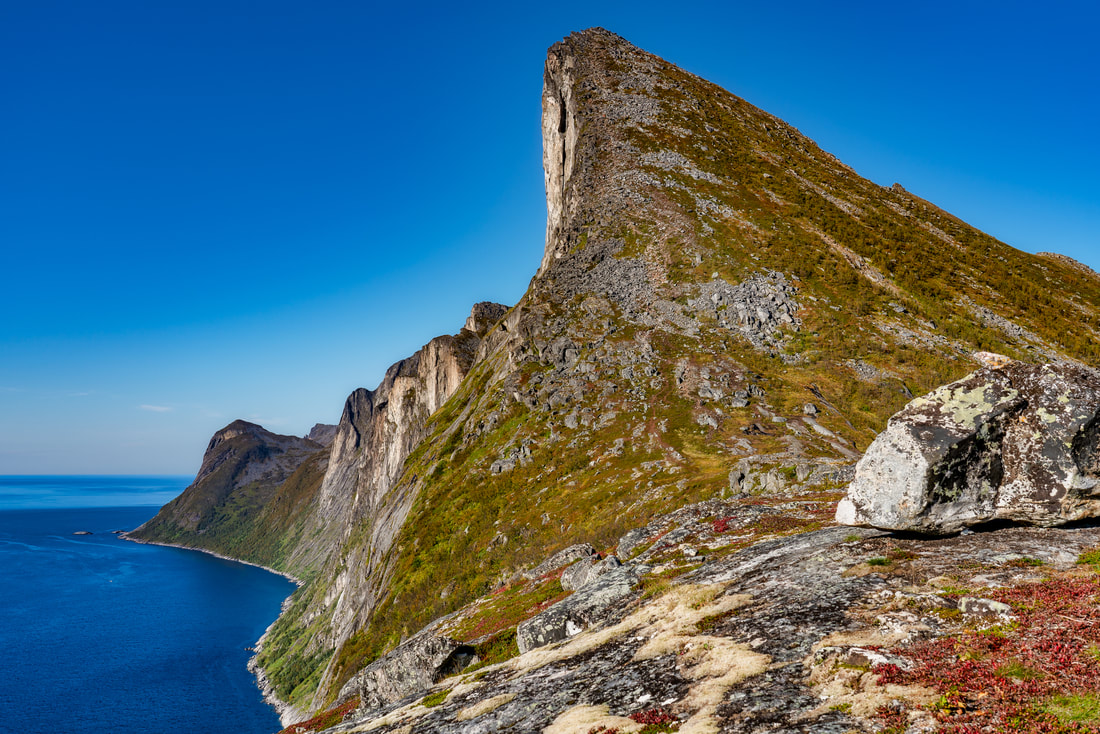 autumnal colours on Segla It was a very beautiful day and it was great to be able to admire the views to various directions... without ever getting remotely close to the edge of the cliff. 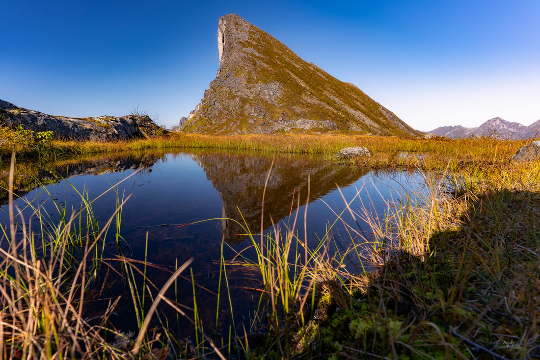 Segla reflections The trail up to Segla was quite steep but not particularly difficult, although it was easy to see that it could be a bit more dangerous in slippery conditions. Even though it was the wrong mountain when it comes to getting the more famous view it is a popular and attractive hike and I recommend it to anyone who happens to be passing through Arctic Norway. After safely descending and remembering to eat (sometimes difficult to remember when I am on a trip, far too easy to remember at all other times) I headed back towards Hamn i Senja, checking out some possible evening aurora compositions and other points of interest on the way. 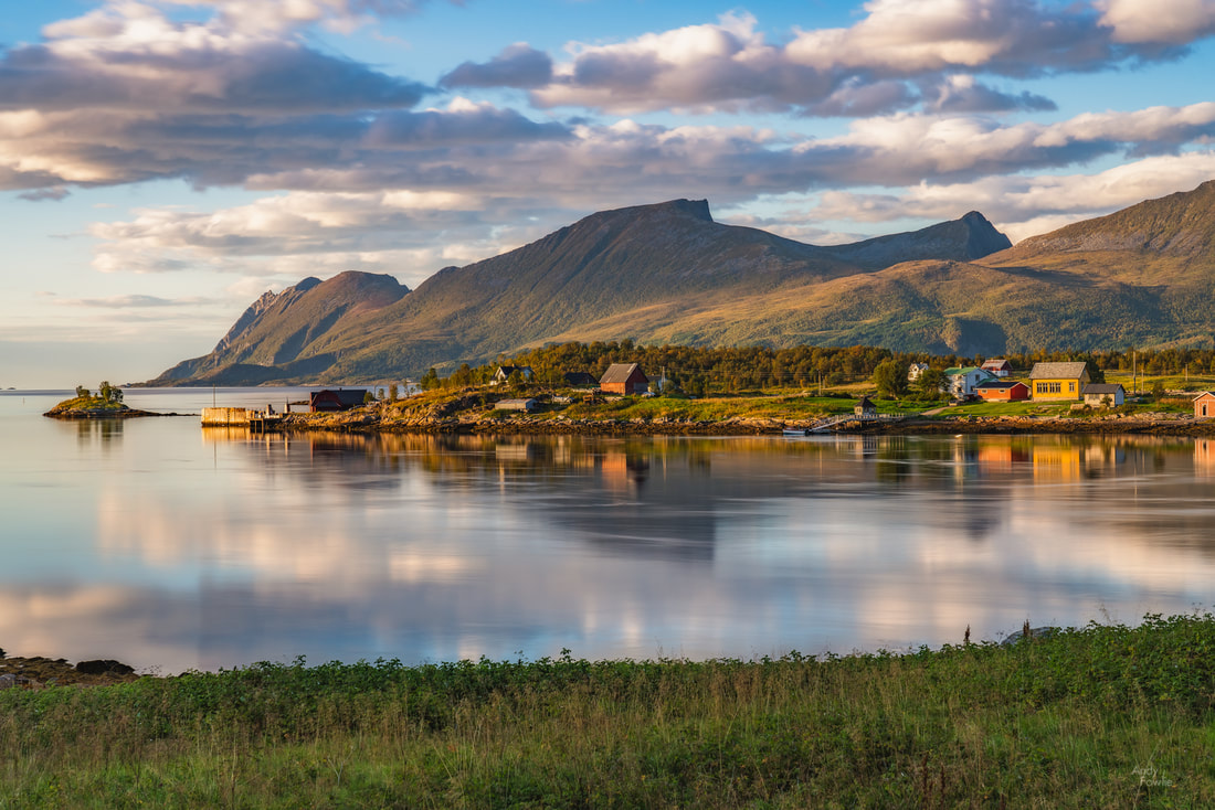 a peaceful scene near to Straumsholmen As I waited for the evening I was keeping half an eye on both the weather forecast and the aurora forecast, both of which can be easily followed on any smartphone. I use an app called My Aurora Forecast to check the Kp index and AccuWeather to guess whether the skies will be clear enough, there are dozens of other apps which probably do just as good a job. It is important to follow both forecasts because even with the strongest auroras you are not going to see much when the sky is completely overcast. On this occasion the aurora forecast looked good but the weather forecast was indicating only a small window of clear skies. I set out to try and be in position if an opportunity came my way. I usually look for reflection opportunities when considering possible aurora locations, and I still feel that to be a good route to strong aurora photographs, but on this occasion I took a different approach and headed for the nearby Senjatrollet amusement park... an attraction based on trolls, as we all know trolls are terrifying man-eating monsters that come out at night. 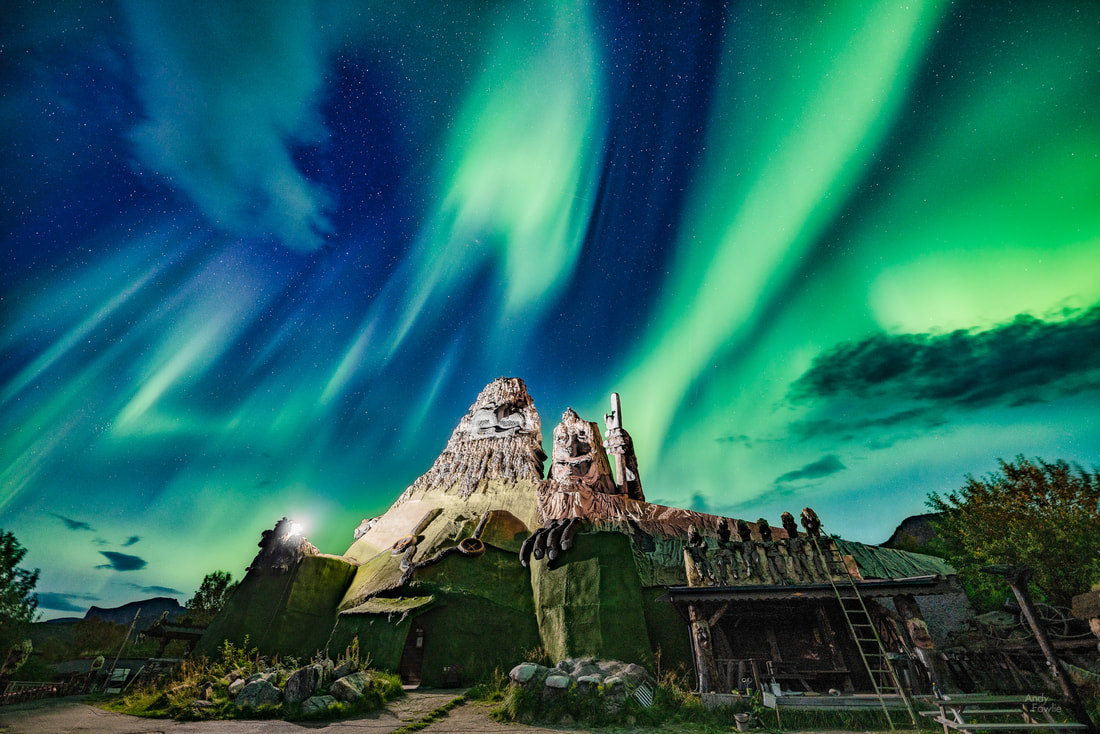 auroras dancing above the Senja Trolls I managed to survive my encounter with the trolls and drove along a mountain road to the beach at Ersfjord where I had seen some tidal pools earlier in the day that might be used for aurora reflections, but by this time the auroras were fading away and the clouds were gathering, there were no further opportunities on this occasion. The following day it was time to leave Senja behind and head south to Lofoten, a distance of a bit over 200km as the crow flies but over 500km by road (those pesky mountains and fjords!). The weather was highly variable during this part of the journey, ranging from beautiful blue sky to fully miserable overcast and rainy conditions. As usual there were many temptations to stop, one of which came at this waterfall framed by autumn colours which I was able to spot from the road and then navigate towards on foot through a wood. 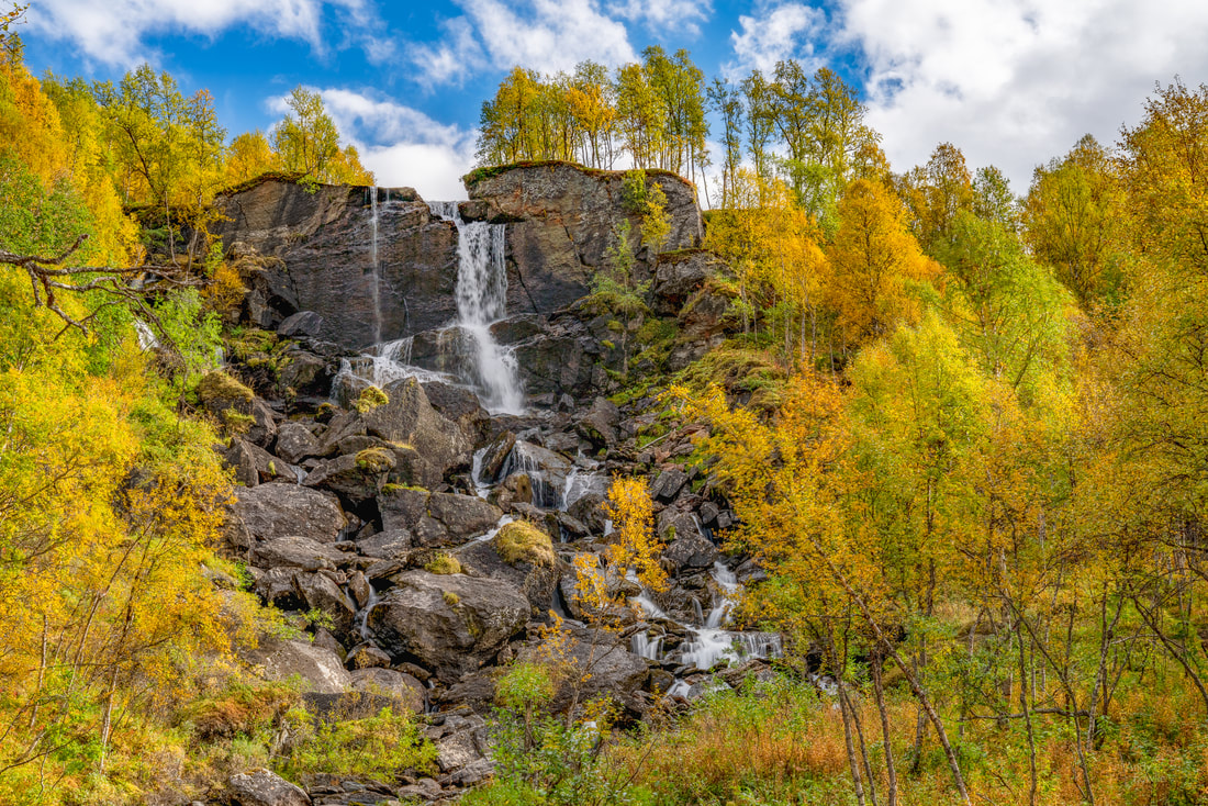 an autumnal cascade There is a certain electricity pylon, near to a certain bridge, some kilometres before reaching the town of Svolvaer, where I have seen a white-tailed eagle perching almost every time I have driven past. On this occasion there was a change in that situation, but to a positive direction, there were two white-tailed eagles sitting there!  a pair of mature white-tailed eagles In a now familiar routine I parked in a lay-by and tried to find a good position to photograph these magnificent birds without unduly disturbing them, all the while looking out for the moment when one or both decided to fly off to other parts of their territory. They were both sitting rather close together and when one upped and left the other had to take evasive action to avoid getting a wing in the face. 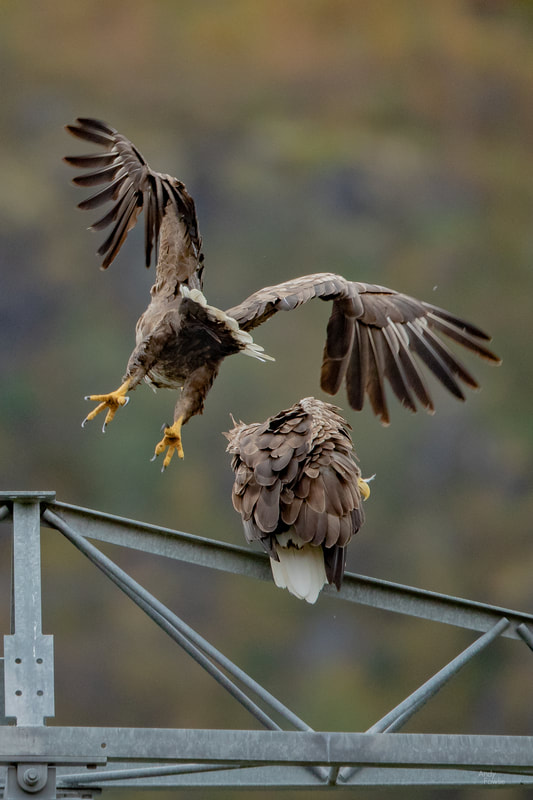 mind where you are flapping those things! It seems like this "flapping in the personal space of another avian" would be a breach of etiquette in polite eagle society but the other eagle did not seem unduly concerned as it smoothly handled the situation. 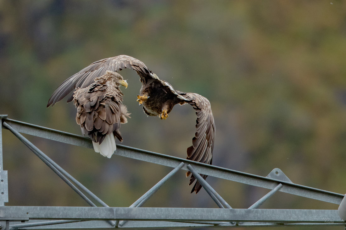 the departing eagle offered a good view of it's powerful talons With that eagle excitement behind me I continued into Lofoten, that magical chain of islands which is becoming quite familiar to me these days, this being the 4th trip there in less than 20 months. I would stay the first night in Leknes before continuing to my usual accomodation in Reine. I chose Leknes as an intermediate base as it is the closest town to the spectacular beaches at Haukland and Uttakleiv and would make it easier for me to be at one of those for the trio of active times (sunrise, sunset, auroras). After checking in to my accomodation I headed for Uttakleiv. 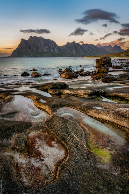 the sunset colours begin, orangey yellow on the horizon The sunset on this evening was quite an attractive one, cycling through a wide selection from the colour palette as the day came to an end. 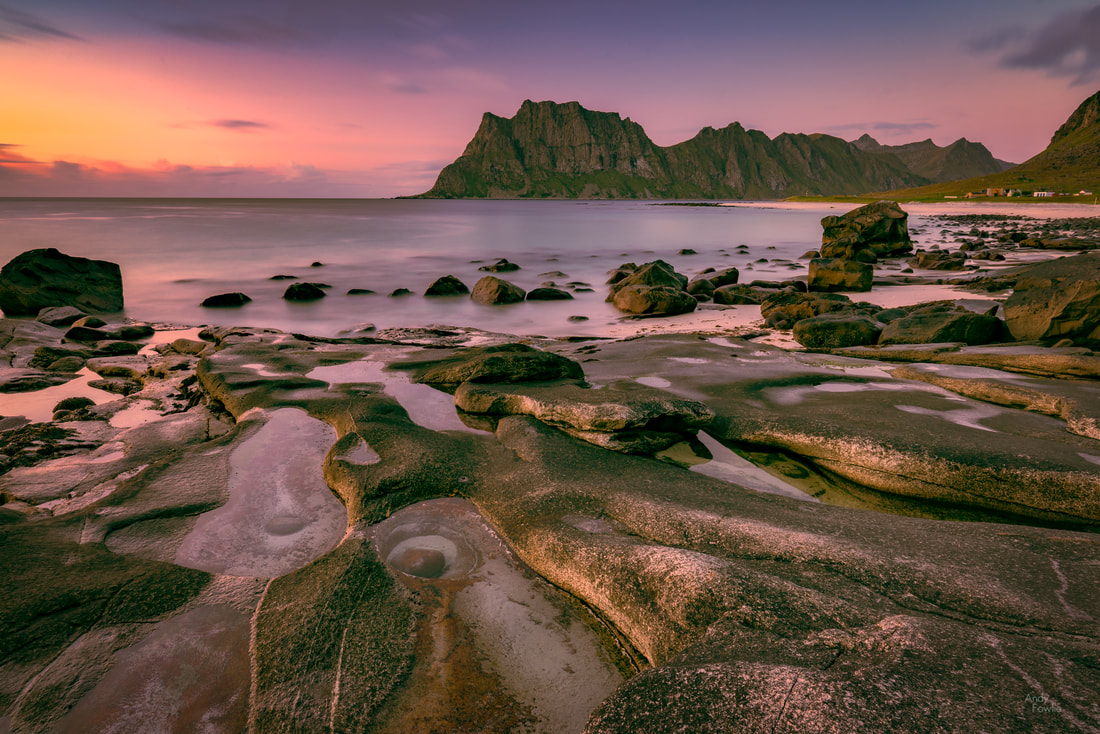 as it gets noticeably darker the colours get to their maximum with smooth oranges pinks and purples. An 80 second exposure had a significant calming effect on the crashing waves. Each time I have visited this dramatic beach I have found some better ideas for how to photograph it, but it is still a bit of a difficult location. 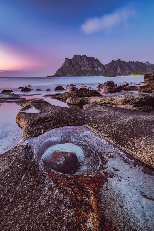 the drama starts to fade away, leaving a more peaceful scene. This time a 114 second exposure was chosen. The auroras were still visible on this evening but they were not that strong and not in the right place in the sky for my chosen spots, I did a bit of searching for alternatives without any huge success. 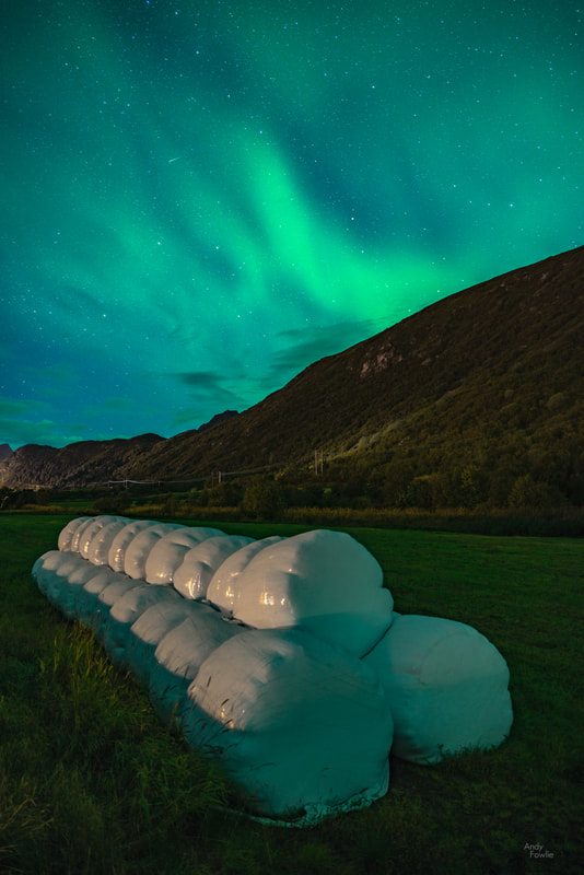 hay bale auroras... it seems this was the best I could come up with. After a good night's sleep, skipping the sunrise based on the (weather) forecast and resting up ready for the rest of my trip, I was ready to leave Leknes and continue towards Reine. I shall leave the rest of this trip until my next post, but before I sign off here is one final picture from a small lake near to Leknes. 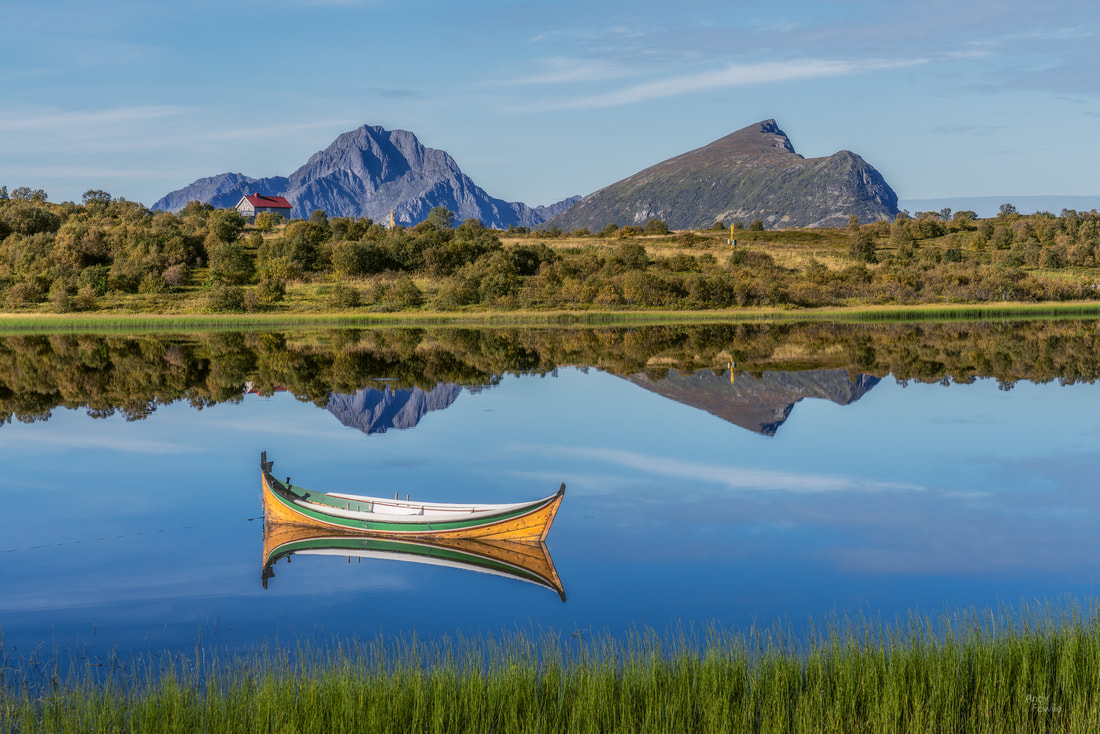 a peaceful scene near to Leknes Until next time! Andy
2 Comments
Over the past few years I have seen many images of the jagged peaks, alpine meadows and beautiful lakes of the Dolomites and a visit to that area in the north of Italy has been high on my wish list... at the end of August I finally got my act together and organised a short trip to the area. I took an evening flight to Venice and stayed overnight in a guest house at Ponte Nelle Alpi... in a violently horrendous thunderstorm. The guesthouse was on the top of a hill and very exposed to the elements. The rain hammering off the window, the howling wind and the thunderclaps directly overhead meant that I did not get much sleep. The coffee at breakfast was most helpful in my recovery and I continued my drive north. As I got to higher ground I found that the storm had completely disregarded all thoughts of it still being summer and had dumped 10-15cm of snow on all ground above about 1600m altitude. 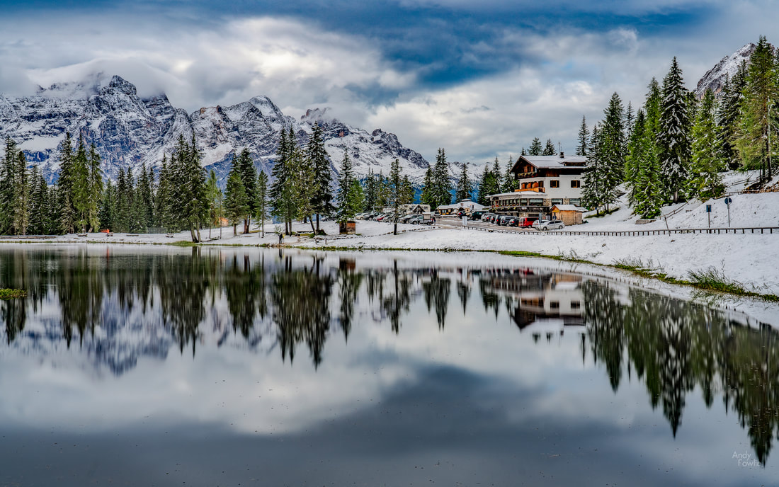 Lago D'Antorno in the snow I drove to Misurina lake but did not find that to be too photogenic, so I continued along the road to Lago D'Antorno which was more to my liking. I find that in order to get good reflections it is best to use lakes that are rather small (ponds and puddles are also acceptable) in order to keep your subjects more immediate and prominent in the frame. Both of these lakes are on the road which leads to Tre Cime di Lavaredo and my idea was to drive up the steep toll road and maybe do the circle hike around those iconic peaks. The car parks at the top of the road, holding at least a thousand cars, were already full (about 11am, on a slightly unpleasant day) and as a result they were operating a "one in one out" policy on the toll road with a sizeable queue. Instead of joining the queue I returned to Lago D'Antorno and decided to follow the toll road on foot. I had read an account from another photographer of doing the same thing in deep snow in winter and he described it as an easy hike taking about 40 minutes so I was quite confident. I am not sure what kind of physical specimen wrote that other blog but I can say that apart from the smooth road surface there was nothing whatsoever which was easy about that hike - an unremittingly steep slog which took me at least an hour and three quarters and left me extremely tired, despite the beautiful views. 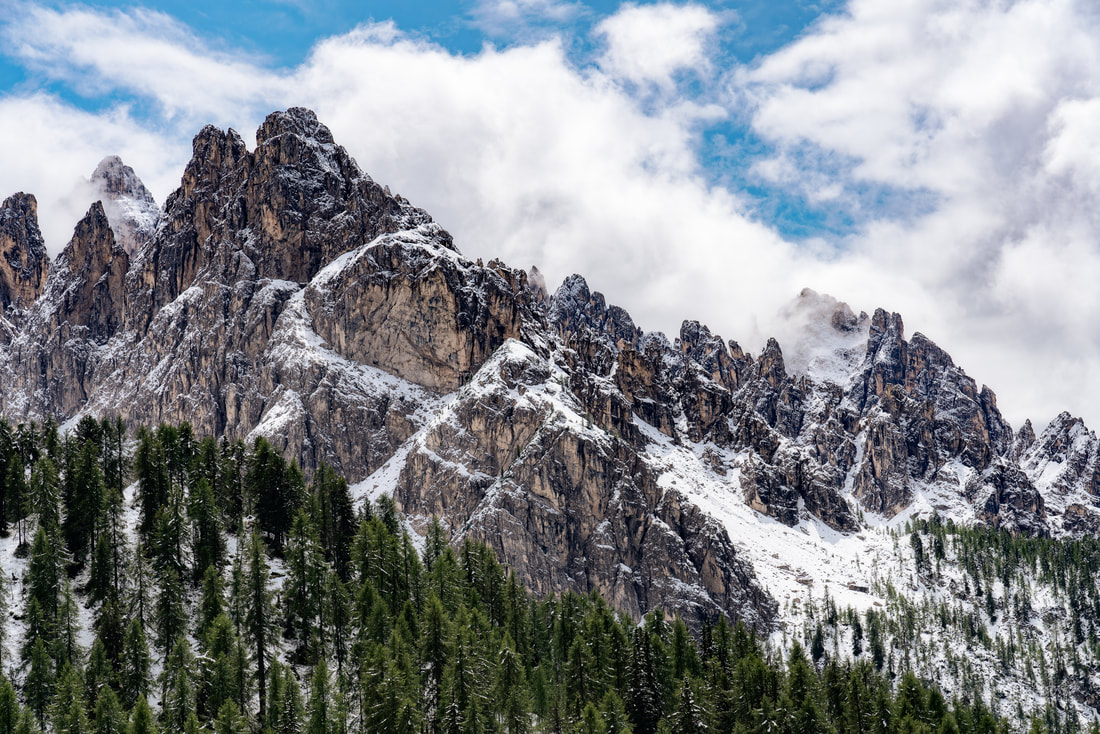 after the snows After spending so much effort on the climb I decided not to do the 4-5 hour circle hike around Tre Cime, the clouds were looking rather dark and moody and I did not want to get stuck in a storm, so I decided to retreat back down the road and check in to my accomodation. I chose a hotel close to Cortina D'Ampezzo as my base for the trip on an "it looks like it is roughly in the middle of the places I want to visit" basis and I was happy to find that it was in quite a beautiful spot. 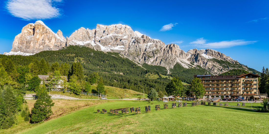 my humble hotel As a location it also turned out to be quite good as it was quite close to what turned out to be one of my absolute favourite spots, the top of the Giau Pass. As the day ended to skies cleared and sunlight bathed the snowy ground.  Passo di Giau Although I usually do at least some research on specific locations before embarking on my trips I find that there is no substitute for actually viewing a location in person. With mountain locations especially it is hard to reliably translate "kilometres on the map" into "time taken to travel" and plans made without knowledge of the terrain can easily turn out to be unrealistic. I decided to treat this trip as a scouting mission, meaning that I would try to visit as many sites as possible in my 3.5 days in order to understand where to focus in a future "proper" photography trip. The next morning I was out of my room at 0430, ready to try and do some astro photography at the Giau Pass and then wait for the sunrise, but I faced an unusual difficulty - I could not get out of the hotel! The door was locked and bolted, the reception was empty, there was no bell, there was nobody around and there were no other exits. I made some noise (enough too attract the attention of anyone who would be there, but not enough to wake the hotel residents) and waited around for 15 mins to see if anyone came along... but no. Trapped. I went back to bed. Three hours later the day began properly and I drove up to the top of the Falzarego Pass.  a mountain hut at the top of the Falzarego Pass From here it was possible to travel by cable car to Lagazuoi, a 2835m peak. Although this was the second highest altitude I have reached (without the aid of a plane that is, the Zugspitze summit being my highest point) it was still possible to look up from Lagazuoi to even taller peaks in the surroundings. 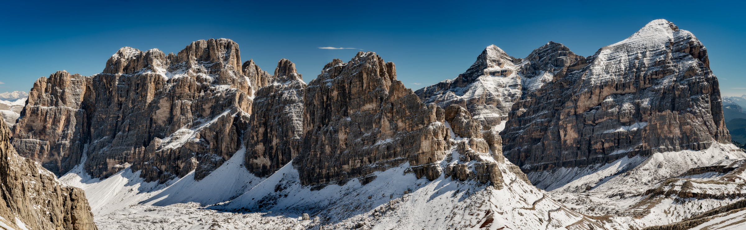 the Tofane mountain group is on the right of the picture, the three mighty peaks reach 3235m, 3244m and 3228m From Lagazuoi it is also possible to look down on a much more famous neighbour, the small cluster of peaks which make up Cinque Torri, a kind of natural monument in the middle of nowhere and a popular destination for climbers. 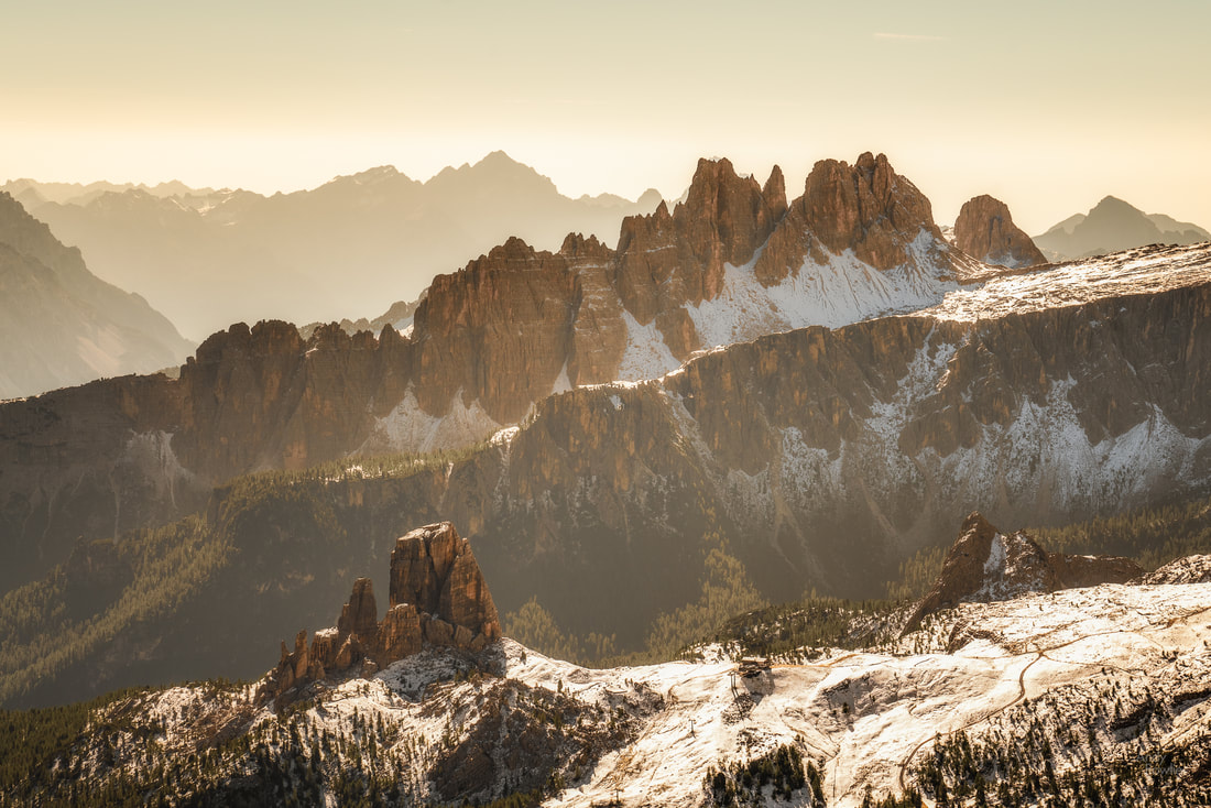 Cinque Torri (lower left) is bathed in sunshine as the beautiful mountain ranges of the Dolomites provide a fitting backdrop Near the summit of Lagazuoi you can get a closer look at some fortifications dating from the Great War over a century ago. The front line in the battles between Italy and the Austro-Hungarian empire went right through this area and all over the Dolomites it is possible to see evidence of the desperate struggle which took place between the opposing forces in the harshest of environments. 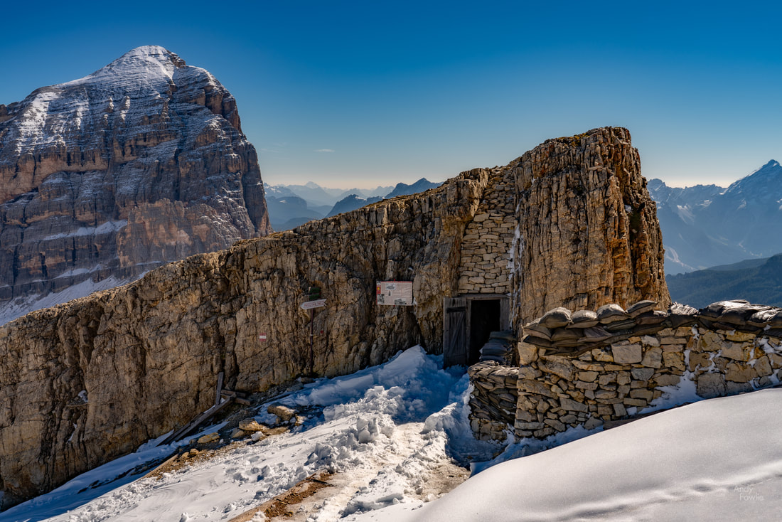 a fortified position and a gallery tunnelled into the mountain itself... warfare at over 2700m altitude. There is a lodge at the top of the cable car route where you can eat something, get some coffee or even stay overnight. These Rifugios are a feature of almost all easily accessible peaks and mountain areas in the Dolomites and make it a lot easier and more comfortable to spend time in what would otherwise be the wilderness. On this occasion there was some construction work ongoing at Rifugio Lagazuoi and while I was there a helicopter was constantly shuttling materials up and down the mountain without ever landing. It was impressive to watch. 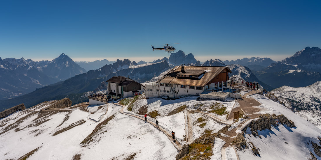 the helicopter in action It was time to continue my journey, starting by entrusting my life to a few rather insubstantial looking wires as the cable car made its descent.  from the cable car... yikes! I made my way to the Gardena Pass, another spectacular tour through mountain peaks by way of hundreds of hairpins.  Passo Gardena My objective was the Seiser Alm, a vast mountain meadow surrounded by peaks. There are many different ways to reach the Seiser Alm, but during the day it is forbidden to drive there, you have to approach by cable car. I had partial directions to get to the spot I was aiming for - I took the cable car to Compatsch and then a bus to Saltria... but then I was not quite sure where to go next. I wondered around for an hour or two but I don't think I found the best views.  a lone horse poses in front of the mountains When visiting this area again, and especially in order to get to the best places at the best times for photography (sunrise, sunset, night) I think that a totally different approach would be needed. Normally I like to have a single base and then travel to different locations, but in the Dolomites there would be huge advantages to staying in a different Rifugio every night in order to be as close as possible to your subjects.  a nice spot for a mountain cabin This was a very long day... some 4-5 hours of driving as well as multiple cable car journeys and about 20km of walking... so I was happy to get back to my hotel and get some rest before the morning. The next day I also planned a long journey, heading this time a bit further north before circling round to an area near to where I had been the day before and returning via the Gardena and Falzarego passes. My first stop, before 6am, was at Lago di Landro.  the sun hits the mountain peaks at Lago di Landro From there I continued to Lago di Dobbiaco having first satisfied the demand from my rental car which instructed me to add at least one litre of oil "immediately".  a small weir at Lago di Dobbiaco The final part of my morning lake trilogy was the famous Lago di Braies, a very beautiful place but also a horrendous tourist trap. My advice to anyone wanting to enjoy this place is to arrive very early in the morning or very late at night, it was slightly uncomfortable already when I arrived at 0830 and by the time I had completed the easy hike around the lake it was absolutely swarming with what seemed like many millions of people.  the boathouse at Lago di Braies Having gladly removed myself from the multitudes at Lago di Braies I made my way to the next famous destination, the church at Santa Maddalena. This was a location I had been looking forward to perhaps more than any other, but it was a place where the experience did not quite measure up to the expectation. It seemed to me that the place had not quite made peace with its status as a tourist attraction. It has managed to embrace some aspects of that, such as charging a few euros for a parking place, but the overall feeling is one of being a bit unwelcome. The church is in the middle of a field, but according to the signs it is prohibited to walk around in that field which rather limits your chances for photography. There is a tiny platform that you are allowed to stand on in the corner of the field, which means that everyone who obeys the local rules will end up with almost exactly the same picture as each other. Drone photography is also prohibited there, which is another limitation. I think that if they would accept that the place is and will be a tourist attraction and make a little bit more effort to be accommodating, while also charging a bit more money for parking if necessary to make it a sensible business, then everyone might end up being more happy.  Santa Maddalena The whirlwind tour continued and it was time for the next destination. It had been nearly 20 hours since I took a cable car journey so I decided to fix that by ascending to the spectacular peak of Seceda (2519m). This mountain provides some other-worldly views as it looks like the ground has just been ripped apart at the seams, on the one side pleasant green meadows slope steeply upwards and on the other side there is a vertical drop of hundreds of metres.  the meadow at Seceda 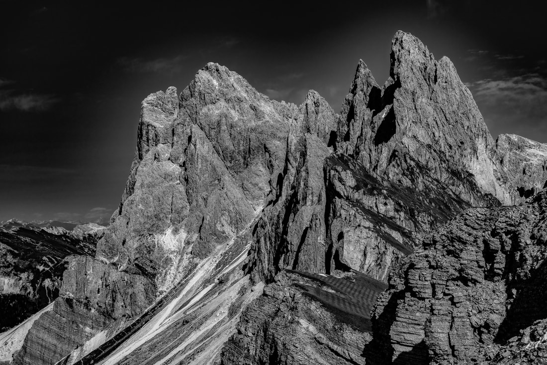 the Seceda summit and "the other side" of the meadow After another rather exhausting day it was very easy to fall asleep... and a bit of a struggle to avoid doing just that while driving back to the hotel. My final morning in the Dolomites was reserved for completing my mission to Tre Cime di Lavaredo, having had a false start in that adventure on the first day. The toll road does not open until 0600 which makes it a bit of a challenge to be in position for the sunrise in the summer, but I was the first one through the gate on this day and determined to make the best of it. I parked in the massive car parks near Rifugio Auronzo and started the circle hike around Tre Cime by around 0615. 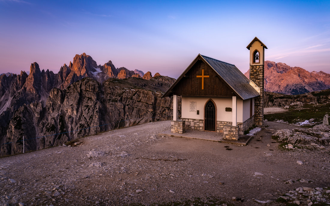 a small chapel near to Rifugio Auronzo, at dawn The hike, which took me about 5 hours, could be thought of as a tour of different Rifugios. The trail starts at Rifugio Auronzo and then (in the direction I travelled) leads you to Rifugio Lavaredo, Rifugio Locatelli (Drei Zinnen Hutte) and Malga Langalm before completing the circle at Rifugio Auronzo. Each leg of the journey takes about an hour. 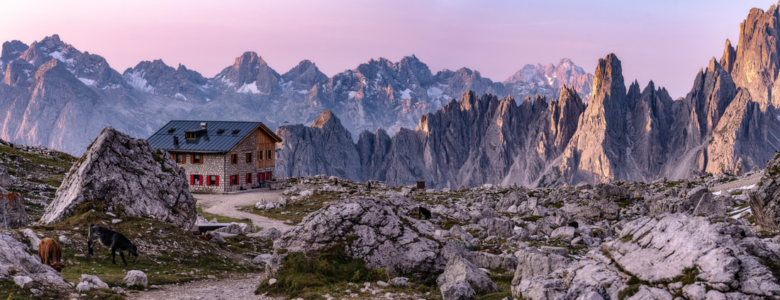 Rifugio Lavaredo in soft morning light The temperature was something of a challenge during this hike, it was 3 or 4 degrees when I started before the sunrise and 31 degrees when I finished about midday... luckily I had pretty much expected this and had dressed on a "I will warm up eventually" basis, accepting to be a bit cold to start with in order to have the benefit of not having to carry extra clothing in the second half of the hike. 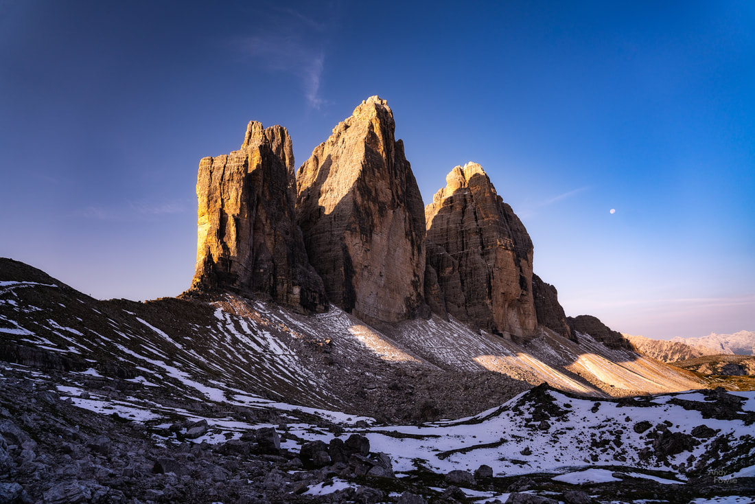 Tre Cime di Lavaredo (2999m) as the sun hits it for the first time The trail is easy to follow and well maintained, but there are some noticeable changes in elevation at various points, requiring quite a lot of ascending and descending even though it is roughly level overall. 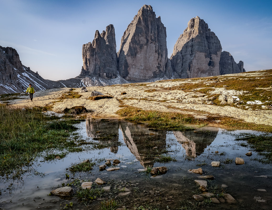 Tre Cime puddle reflections By the time I was approaching the Drei Zinnen Hutte, about half way round the hike, a coffee was definitely needed. I stopped for 20 minutes to recharge my batteries. This mountain lodge is in an amazing location on the mountain plateau. 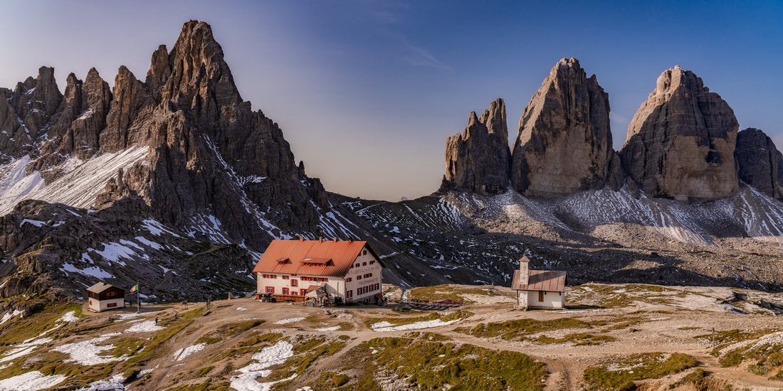 Drei Zinnen Hutte, backed by Monte Paterno (left) and Tre Cime di Lavaredo (right) This was the most spectacular place on the circle hike in my opinion, but the views in general in all directions were quite amazing and I highly recommend the route to anyone who has the opportunity and capability to experience it.  some meltwater helps me out with reflections... a marmot was shrieking encouragement to me from the top of a nearby burrow With that, it was time to make my way back to Venice Marco Polo airport. This was my first visit to the Dolomites, but I truly hope it will not be my last. Whenever I get a chance to return I think that these hectic few days have provided me with some good lessons for how to make a successful second trip. The key for that would be to stay in a number of well selected Rifugios rather than one central hotel and accept the slight inconvenience of regular check in - check out as a price worth paying for being in the right place at the right time. Until next time! Andy In my last post, I signed off from the 1600m high summit of Rossfeld... so that is from where I will continue. As I mentioned the border between Germany and Austria runs through the middle of Rossfeld, the border line is indicated by a number of small white square stones that have a D for Deutschland on one side and an Ö for Österreich on the other. This allowed me, for my own amusement (and probably nobody else's...), to set my tripod up with one leg on the border and one leg in each country in order to take the following photograph. My thought was that the top part of weather station looked a bit like a droid...  searching for the rebel base It may be that a lack of food and lack of sleep were affecting my thinking at this point :) Breakfast helped restore some of my capabilities and I decided to head back across the border and make a visit to the village of Gosau and the lakes at Gosausee which was about an hour's drive into Austria, near to the mighty peaks of Dachstein. In this part of the Northern Limestone Alps the geology is just right to produce spectacular jagged peaks similar to the Dolomites in Italy, making it very attractive to look at and of course to photograph. 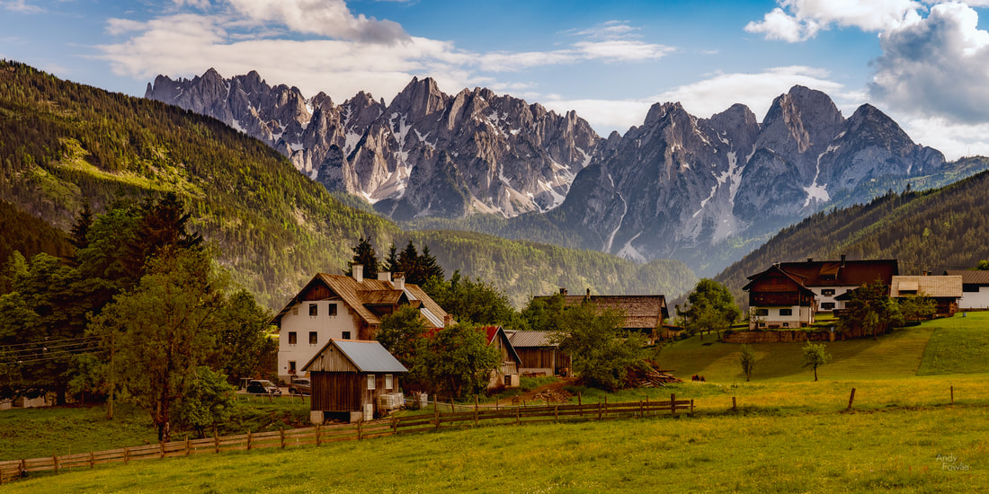 some houses in Gosau, with their spectacular mountain backdrop From Gosausee you can journey to higher ground by cable car but on this occasion I decided to stay closer to the ground and hike along the path to the the upper Gosau lake. I did not study the signs very carefully but it was possible to see that the route was "suitable for families" and should take about an hour and a half. As it turned out this route would require quite a bit of effort as it included a number of sustained climbs along the way, it was quite hard going in the early summer sun. Certainly it was suitable for families, as evidenced by the number of frustrated and tearful children I passed by the side of the road on my way. The hour and a half estimate was probably accurate enough for the downhill journey back to Gosausee but for the uphill outward journey I think that it was over-optimistic. 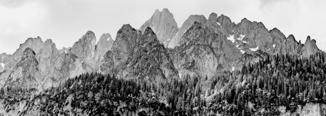 impressive peaks After reaching the upper lake I continued round the lake to the most welcome sight of the day, the Hohe Holzmeisteralm restaurant, where I could refuel with some cold drinks and a plate of bratwurst. The views around the Gosau lakes were spectacular but the light was too harsh to make for successful photography. I made my way back down the hilly path and drove back to the attractive Gosau village. It seems to me that the Germans and Austrians have a huge appreciation for the beautiful scenery of their home lands, they seem to be at their best when out in nature and quite at peace with their surroundings. You almost always get a friendly greeting from the "locals" whenever you meet them whereas other tourists tend to be a little more suspicious. 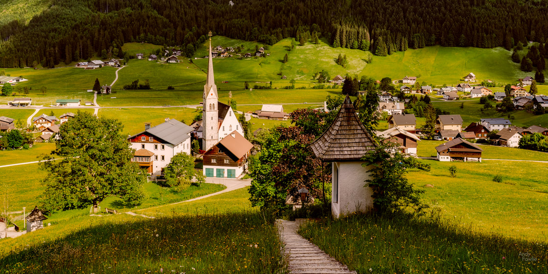 from the hill above Gosau After wandering around the village for a while I had a look at the map to see what I might do next and realised that I was rather close to Hallstatt, an idyllic village which is also a UNESCO world heritage site. I have tried on a number of occasions to organise a short trip to Hallstatt but the hotels there seem to be permanently full (or at least the ones that mere mortals can hope to afford are permanently full), so I decided to go there and check it out rather than returning directly to Berchtesgaden. Hallstatt, as it turns out, is quite the tourist trap. As you approach by car you are carefully funnelled towards a sequence of car parks (costing about €3 per hour for the first few hours) from where you continue your visit on foot. The village itself is very nice, but also very touristy, and packed with people. When it comes to photography there, it is of course possible to find different views with varying levels of interest, but the main view is only easily photographable from one single public place - a 10m long gap beside the road from where you can get a view of the church against it's mountain backdrop. This space was packed with photographers. 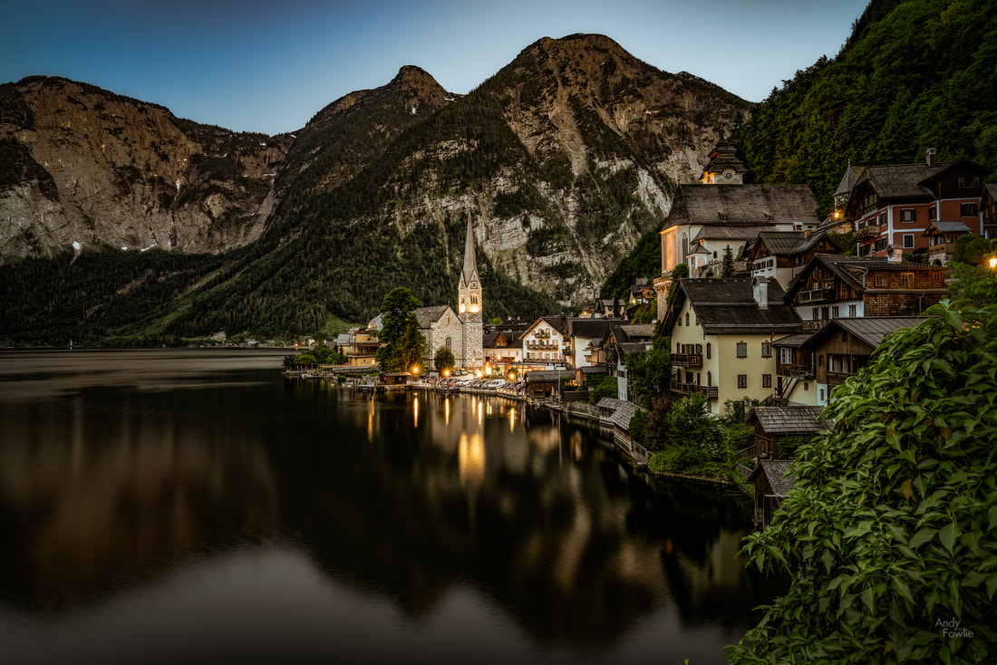 Hallstatt at dusk I realised that I did not like the place enough to visit it again, so I decided to get some food and wait for dusk so that I could try and get a decent picture from the one viewing place. I believe that the best time to be there would have been sunrise, the village being in shadow well before sunset due to the mountains, but an early evening shot would have to do. As I got back to the car I could see that I had exceeded 40 thousand steps for the day, and it felt like it. The journey back to my accommodation in the dark was a careful one. A new day dawned and it was time to change locations - the final two days of my trip would be in Garmisch-Partenkirchen, revisiting some locations from my earlier trip where the weather was mostly un-cooperative. On that occasion my main target was the hillside above Geroldsee, where some alpine cabins decorate the sloping field with the lake and the mountains in the background. I didn't get what I wanted then, so I continued the search for the right conditions on this trip. 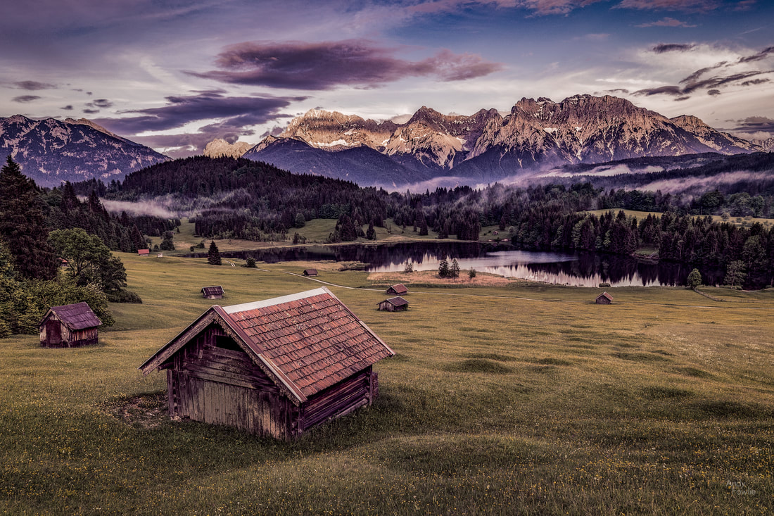 evening at Geroldsee The mountains leave the scene largely in shadow at sunset (at least at this time of the year) and also partly at sunrise, so the ideal combination for Geroldsee is probably to have mist which endures for an hour or so after sunrise, allowing some diffused light to illuminate the scene. When my alarm went at 0430 the following morning the conditions looked quite promising, clear-ish but not quite totally clear. As I drove towards the small village of Gerold the conditions changed dramatically... there was a very thick, very local, rather wet mist hanging over the area - visibility of about 50m. 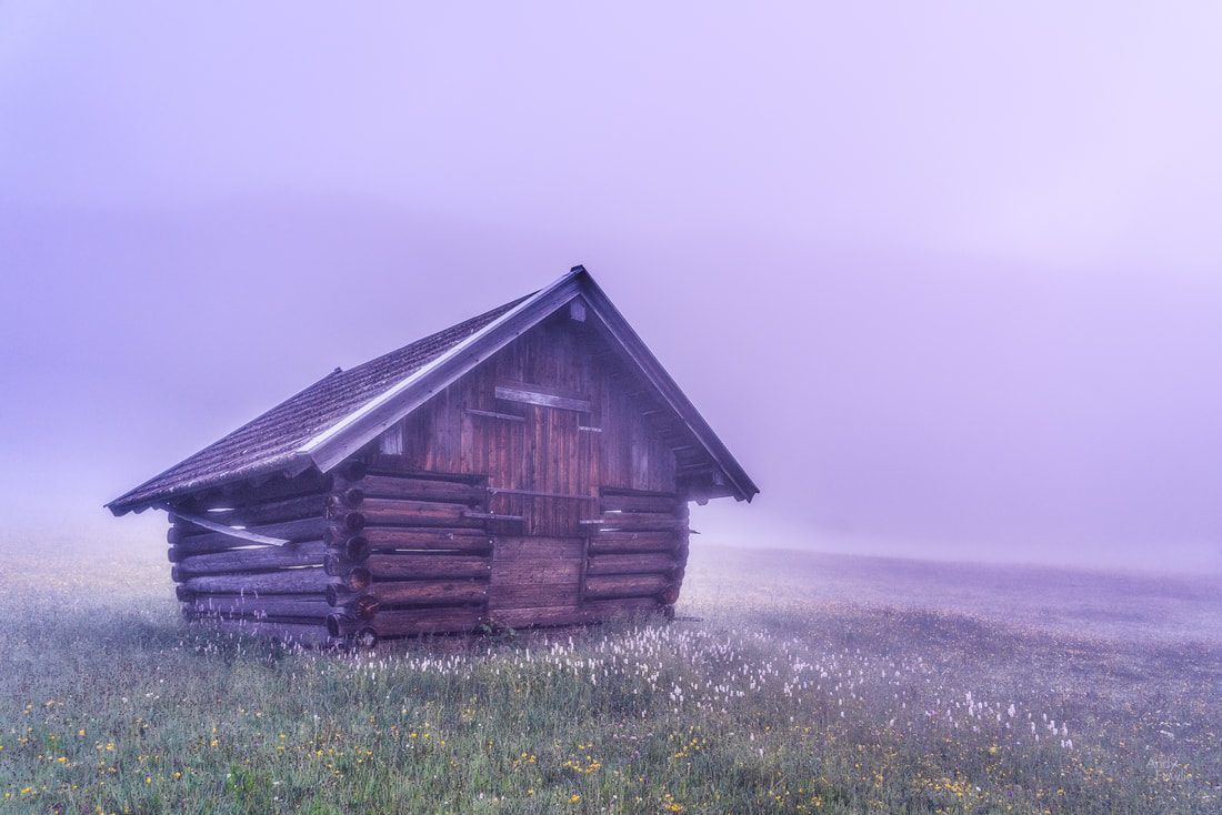 a cabin in the mist Things did not quite look so promising at this point, but I still thought it might work so I climbed the hill to get to a good shooting position, my feet truly soaked by the long wet grass of the meadow. The time of sunrise came and went without any major changes in visibility, this may have been a boring passage of time if I had not been joined by a fellow photographer (and optimist) - Patrick Weinhold had arrived and set his tripod up near to mine. As the sun rose and the mist burned away, we were rewarded for our patience. 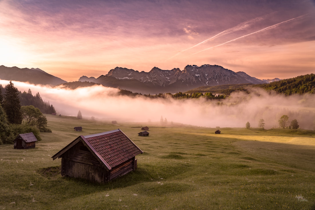 a swathe of mist still covers the lake... It was good to meet Patrick and discuss various photography locations in the area, you can often meet interesting people when setting up your tripod in different locations. 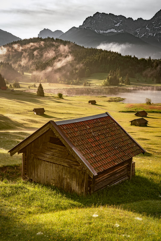 the sun starts to win the battle On this occasion the mist made a couple of small comebacks before finally being defeated, offering good variations in the scene, and we tried to make the best of our chances.  Geroldsee This was a good morning after all and I was quite satisfied with events as I walked back towards my car and said goodbye to Patrick and his dog. I returned to the Werdenfelserei hotel (where I was staying), a completely new hotel which just opened recently, and restored my energy with a truly excellent breakfast. It was a good choice to stay at this family owned hotel, there were still some finishing touches being put to the premises by the builders (it really was that new) but this did not interfere with the experience and it was possible to see immediately from the moment you walked into the reception that they are going to try and do things in the right way there. If they can continue that approach after a month, a year and a decade then it will be a big success. After breakfast, it was time to get high. Almost 3000m high in fact as I headed to the top of the Zugspitze, the highest mountain in Germany at 2962m. The weather remained variable, cloudy with clear patches, which meant that there was a real risk of not being able to see much at the summit, but this was my only chance to be there so I went anyway. There are two easy ways to get to the summit of the Zugspitze - you can take the cog wheel train through the mountain to the skiing station and then a short cable car ride to the summit, or you can take the Eibsee cable car directly from the valley floor (beside the beautiful Eibsee lake) up to the summit. At the ground level cable car station I was able to read that the cable car broke three world records - the longest unsupported span of wire, the biggest difference in altitude from bottom to top and the tallest support tower - for a cable car. This is all very impressive... but if you are slightly nervous about cable cars you really dont want to hear that - you want to know that it has world records for being the safest, smoothest and least frightening. 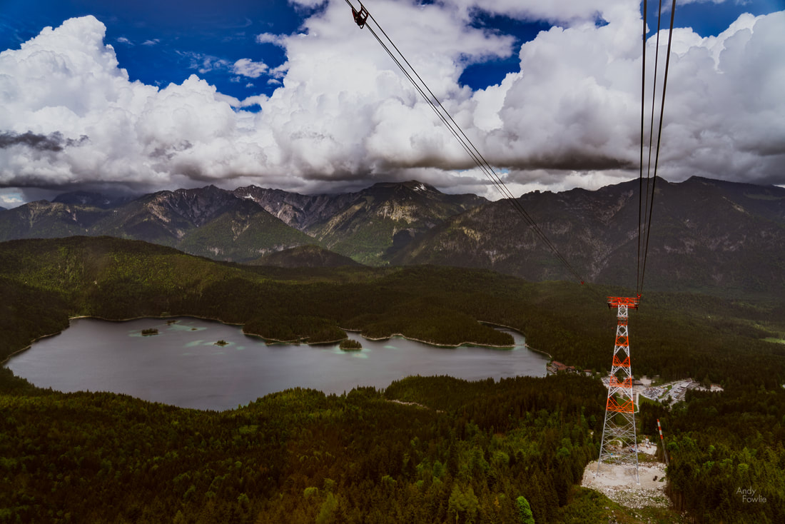 from the Zugspitzebahn cable car Despite some reservations, the journey into the clouds was a smooth one. The cable car ascends quickly (the entire journey takes less than ten minutes, the gondola travelling at nearly 40km/h), the first section is a short one, connecting the ground station to the lone support tower (a 127m tall pylon - meaning that you are over 120m off the ground when the car passes). From there the rest of the journey is without support along the the 3213m wire which stretches between the support tower and the summit. The ride as a whole takes you from an altitude of 973m to one of 2950m. Upon reaching the summit the visibility was about 100m... there was nothing much to see apart from the activities of the Alpine Choughs which were very actively circling above the bratwurst eating visitors on the sun terrace, looking for scraps. 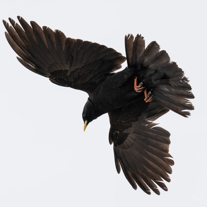 an alpine chough, ready to swoop on any tasty morsels I spent a couple of hours at the summit, hoping for some breaks in the weather, but was not lucky. That is my second time to stand at the very top of Germany, and on both occasions there was nothing much to see... maybe one day I will be third time lucky. 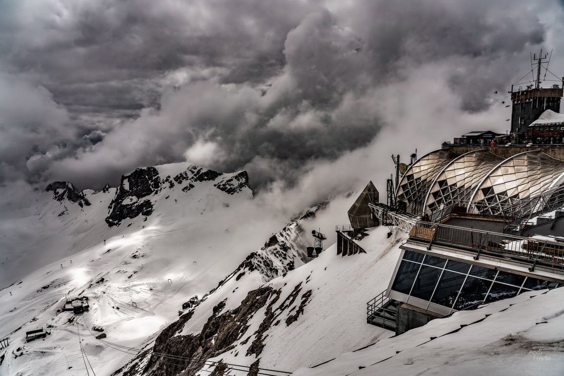 the sun is up there somewhere... at the Zugspitze summit station looking down on the skiing area at the glacier station After descending from the mountain I decided to make the short trip to the village of Wamberg... following a narrow single-track road as it wound it's way up a steep slope. I am not 100% sure that it was allowed to drive that road, I could not understand the German signs... so I was prepared to explain that I was an ignorant and apologetic tourist if anyone objected to my presence. At the top of the winding hill there was a beautiful scene... some mountain cabins with the village church in the background. The weather was cloudy, blocking the mountains, and it was the wrong time of day... but this could be an excellent location in the right light. Another time...  the winding road that leads to Wamberg In the evening it was time to return to Eibsee, at the foot of the Zugspitze, where I hoped for interesting evening light so that I could take pictures of Frillensee, a very small but very beautiful lake. The light let me down on this occasion, so I tried to find some alternative shots that did not require a beautiful sky.  Eibsee boathouse reflections The next day was sadly my last one for this trip, I always feel so at home when spending time in southern Germany. On my way back to Munich airport I made a slight detour to check in on another favourite destination, the spectacular Neuschwanstein castle. This castle is an amazing subject for photography but it is undergoing renovations at the moment and the main gate is covered in scaffolding, spoiling the views that I like the most at this location. Another hazard is the huge swarm of tourists that gathers every day to visit the castle, so I confined myself to having a look from far away... I mean to revisit this location in a few months after the renovations are completed. 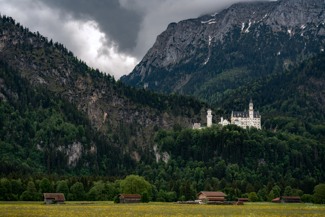 Some nasty weather at Neuschwanstein Thanks a lot for reading this post! Until the next time, Andy The state of Bavaria, in the southern part of Germany, bordering Austria, is simply one of my favourite places to be, and also one of my favourite areas to photograph. At the end of May I made my 5th photography trip to this amazing highlight reel of a region, spending a few nights near Berchtesgaden, followed by a couple of nights in Garmisch-Partenkirchen. By day I split my time between Germany and Austria, crossing the border multiple times as I travelled between destinations. One thing that was immediately obvious as I drove towards Berchtesgaden was how lush and fertile the land was at this time of year. All the fields and trees were the brightest of colours and the plentiful birdlife was highly active wherever you looked. 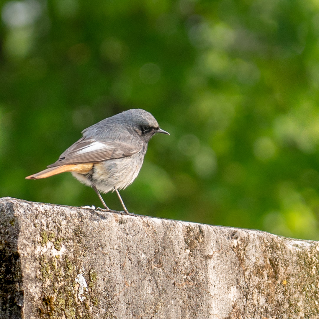 a black redstart at Hintersee... something of a favourite of mine, these are always a very welcome sight. On my first morning I was at the beautiful Hintersee lake by around 0500. This mountain lake, framed by tall peaks, is a lovely place to be and a really great photography destination. There are some famous views there which have been photographed extensively, but it is one of those places where there are so many possibilities that you can also find your own new compositions.  a misty morning at Hintersee There is an "artists path" which follows the shore of the lake, with different Hintersee inspired artworks displayed at intervals. This walk is exceptionally beautiful, taking in a number of lovely views, and it takes around 30-40 minutes to walk round the lake.  Lush vegetation by the lake shore At this time of year there are great possibilities for misty mornings, and this was a good example of one such morning. Conditions can change very fast once the sun starts to burn off the mist and it very quickly changes from "too much mist" to "not enough mist"... but on the other hand it is quite hard to predict exactly when that change will happen so photographing in these conditions involves a fair amount of waiting around.  as the mist starts to clear The water at Hintersee is remarkably clear and free of pollution and it is also shallow, calm and sheltered - there are possibilities to see the bottom of the lake through the emerald waters and there are also good possibilities for reflections. There are many options available to a photographer when planning a shot.  clear emerald waters... For anyone who visits this area, whether they are interested to take pictures or not, I highly recommend Hintersee as a destination, it made an immediate impression on me when I first visited in 2016 and I have not become immune to it over numerous subsequent visits. It's one of those places you can't get enough of... I wish I was there now. 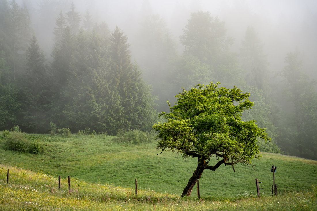 a lonely tree in a spring meadow I could not leave Hintersee without making my version of one of the more heavily photographed views. There are a few rocks in the lake with trees managing to grow directly out of the stone, and they provide an interesting focal point for a picture with the mountains rising on either side (hidden by mist and cloud on this occasion) and the Hintersee village on the right hand side.  a more classic Hintersee view. After the beautiful early morning at Hintersee it was time to retreat to my accommodation for breakfast. On previous visits I had always stayed at the truly excellent Hotel Edelweiss, a superb hotel which I definitely recommend, but on this occasion the Edelweiss was full so I decided to try a different approach, booking into Villa Bello in the village of Oberau, a few kilometres from Berchtesgaden. I chose this location because it was particularly near to Rossfeldpanoramastrasse and I liked the idea of being able to get from my room to the top of Rossfeld (about 1600m) in just a few minutes on occasions when the light looked promising. Villa Bello is a lot more basic and resides at the other end of the price range from the more up market Edelweiss, but I think that both offer great value for what they are. After breakfast it was time to head for my next location, I intended to be on the first boat heading out into the beautiful and peaceful lake Königsee in order to be ahead of the crowds as I made the trek towards the tallest waterfall in Germany, the 470m tall Röthbach falls. 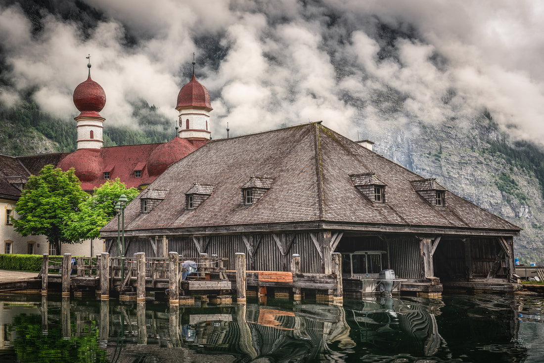 the first stop for the Königsee ferries... the church of St. Bartholma The journey to the Röthbach waterfall is quite a long one, beginning with a boat from Königsee. The first stop of the boat is at the iconic St. Bartholma church with its red roof and towers, but in order to get to the waterfall you need to stay on the boat until the final stop at Salet, a trip of about 30 minutes from Königsee. From Salet it is about a 20 minute walk to reach the north side of Obersee lake. This lake is absolutely the most beautiful and most photogenic part of the journey to the waterfall. At the north side there is a single boathouse which provides a great foreground for a picture of the surrounding mountains reflected in the lake, with the waterfall clearly visible (despite still being kilometres away) in the background. 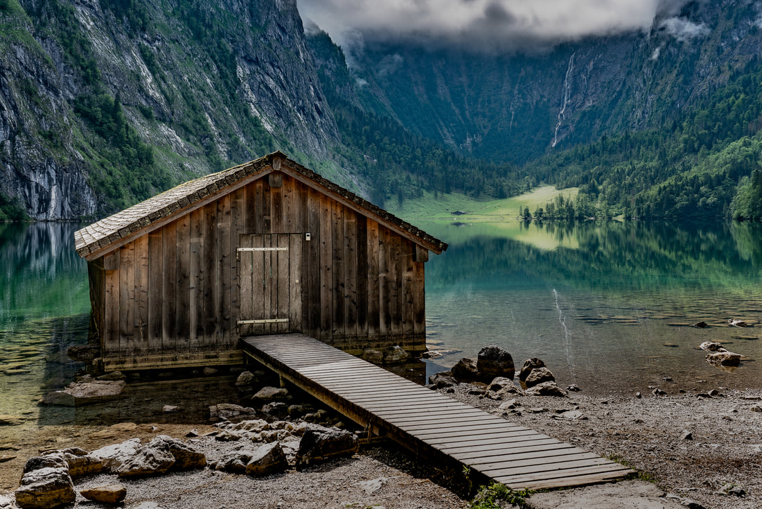 the boathouse at Obersee (north) with the Röthbach falls in the background. The weather on this day was rather variable, the battle between the sun and the clouds was very hard fought and each had their victories, this meant that there were some moments with an interesting combination of light and shadow. 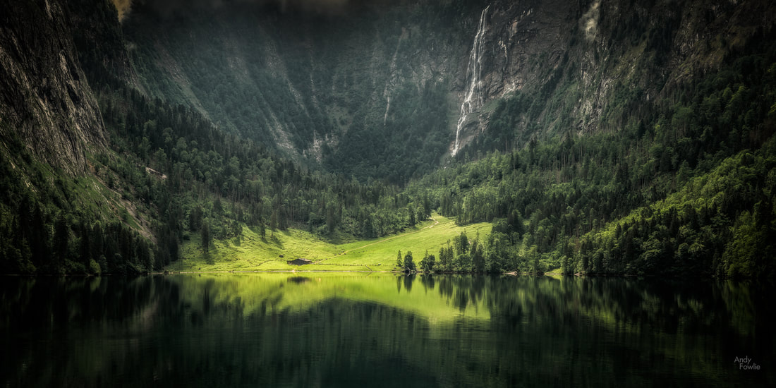 the sun breaks through for a moment to illuminate the southern shore of Obersee Obersee, like Hintersee, is exceptionally well sheltered from the wind and this means that flawless reflections are often possible in the lake surface. The walk around the lake is a bit challenging in wet conditions as the rocky path becomes quite slippery, but there are some very beautiful views to enjoy on the way. 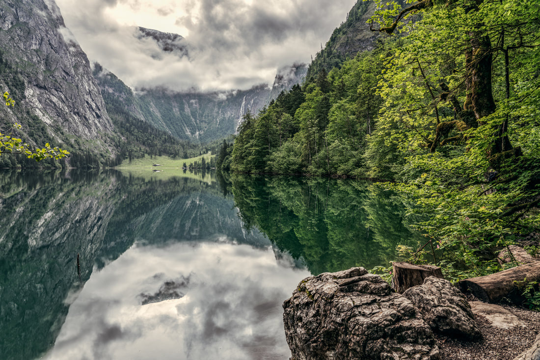 Obersee reflections The walk to the south side of Obersee takes around 30 minutes, depending on the traffic. The path, at the steepest and slipperiest part, is also rather narrow, so it can be quite a bottleneck due to slower moving people in front of you or people returning from the other direction. This was why I wanted to be in the first boat of the day, hoping at least to avoid the two-way traffic on my journey to the falls. At the southern end of the lake you can find another solitary boathouse, looking back towards its counterpart at the northern end. 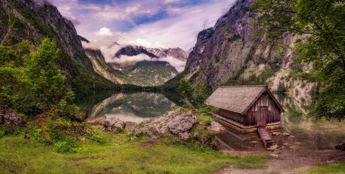 the boathouse at Obersee (south) 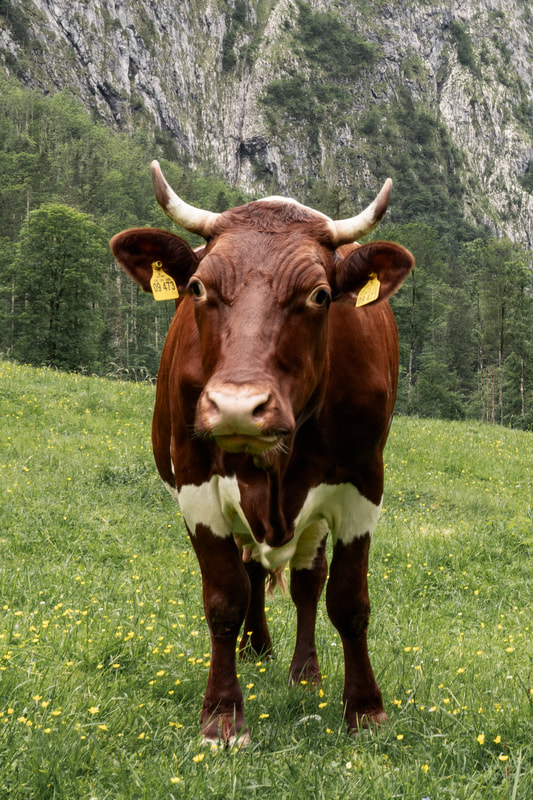 After the boat journey, the hike to Obersee and the journey around to Obersee's southern side it is now time for the final push towards the waterfall. That final part of the journey takes around 30-40 minutes. The waterfall itself is not a particularly good subject for photography when you get closer to it (other opinions may be available on this subject), but it was good exercise and interesting to see it in person. Some of the other observers appeared to be somewhat less interested, this cow only had eyes for the fresh green grass. After completing the return journey to Königsee I confess that I started to be quite tired. Even though it was only mid-afternoon it had already been a long day and I had carried my camera stuff for close to 30 kilometres. I retreated to a restaurant in Berchtesgaden for some food and checked the situation in some photography competitions I had entered. I was delighted to see that one of my staircase pictures from Vienna had won the Top Photo award in the Black and Yellow challenge on GuruShots, an online photography competition. I participate regularly in these competitions and occasionally I manage some successes - I added a "Recognition" Page to this site in order to keep a record of any notable achievements. Restored by the meal, and encouraged by the win, I decided to visit the Maria Gern chapel at dusk. Those who have studied my previous posts might remember that I have shared very similar shots before... but I really like this view and I always want to try and make improved versions or just capture the scene in different conditions. 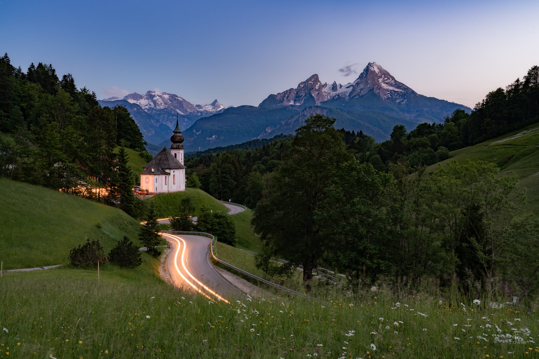 Maria Gern headlight trails, with the Watzmann mountain in the background This trip included such a range of locations that I will have to cover it across multiple posts, but before I conclude this instalment I would like to share some images from my drive up to the summit of Rossfeld the following morning. The Rossfeldpanoramastrasse toll road is a super way to get to a panoramic viewpoint without requiring extensive and time consuming hiking. For a few euros you can get past the gates and drive all the way to the summit at about 1600m elevation. Rossfeld is not a particularly lofty peak compared to many of the surrounding mountains but it is located beside the Salzach river valley which gives enough surrounding space to make Rossfeld a superb viewpoint to many directions. 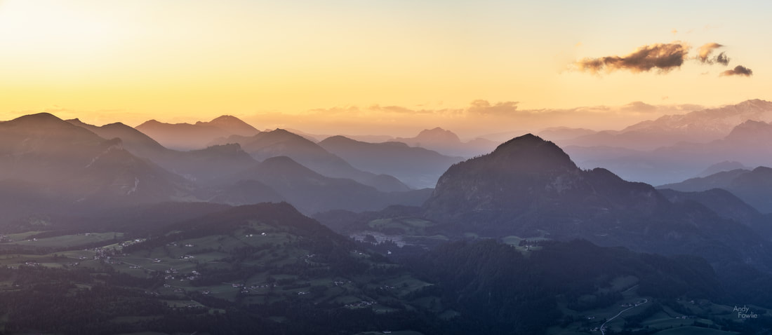 a panoramic view before sunrise from the summit of Rossfeld The summit of Rossfeld is right on the border between Germany and Austria and the available views cover the territory of both countries. It is possible on a clear day to see all the way past the Tennen mountains to the Dachstein massif some 70km away. 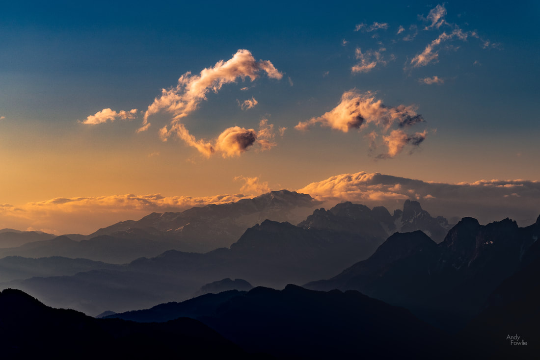 a remarkable "C" shaped cloud looks ready to eat a smaller sibling as they both float in the golden sunrise sky. I have spent many early mornings at the top of Rossfeld, sometimes quite uselessly if the cloud level is low, but so far I have not become tired of watching the sun gradually illuminate the different layers of the valley below and burn off the morning mist. That's it for part one of this trip, I hope that you have enjoyed this post and consider tuning in for part two! Thanks for reading, Andy Earlier this month I made my third visit to the magical Lofoten archipelago in the north west corner of Norway. This amazing area is one of my favourite places to visit and I have had the idea to try and visit at a different time of year each time I go there to try and see the spectacular views in all their different disguises. My previous visits were in March and October of last year so following this trip I only need to visit nine more times to cover every month of the year. Why should you visit Lofoten? The small fishing villages lining the fjords, framed by snow covered mountains, make for some of the most spectacular scenery on earth. 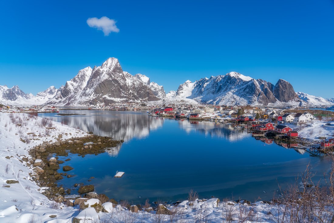 shame about the cloudy weather... the classic view of the village of Reine As with my two previous visits, I made my home in the village of Reine at the lovely red fishing huts of Reine Rorbuer. These red huts maintain their classic external appearance but inside they are maintained to a very high standard, providing a perfect place to stay right in the heart of the most beautiful part of Lofoten. These colourful cabins, or Rorbuer, are a feature of the area and in many villages the predominance of a certain colour or a certain mixture of colours really adds to their character. In Reine and Hamnøy red is the dominant colour, in Sakrisøy yellow takes centre stage while in Nusfjord there is a colourful red, white and yellow mixture. 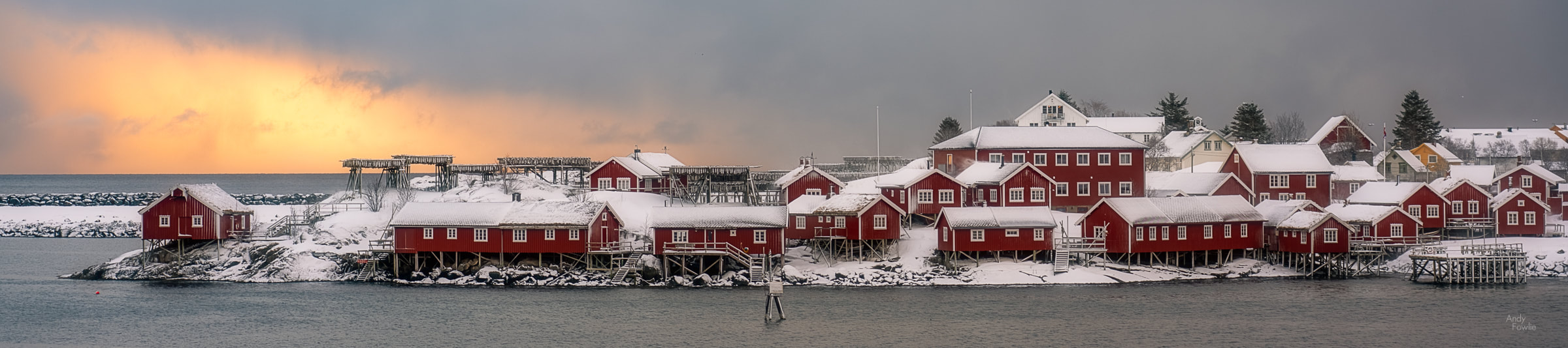 sunset in Reine Although Reine is spectacular in itself, it has some very tough competition for the "best village within 5km" title. The villages of Sakrisøy and Hamnøy are both close enough to reach with a 10 minute drive or within an hour on foot. Sakrisøy, perfectly situated in the fjord with its yellow cabins, has fascinated me since the first time I saw it. It has such a hold on me that it starts to be an impediment to progress on my trips as I cannot easily drive past it without stopping for an hour... and it is on the way from Reine to almost everything else. 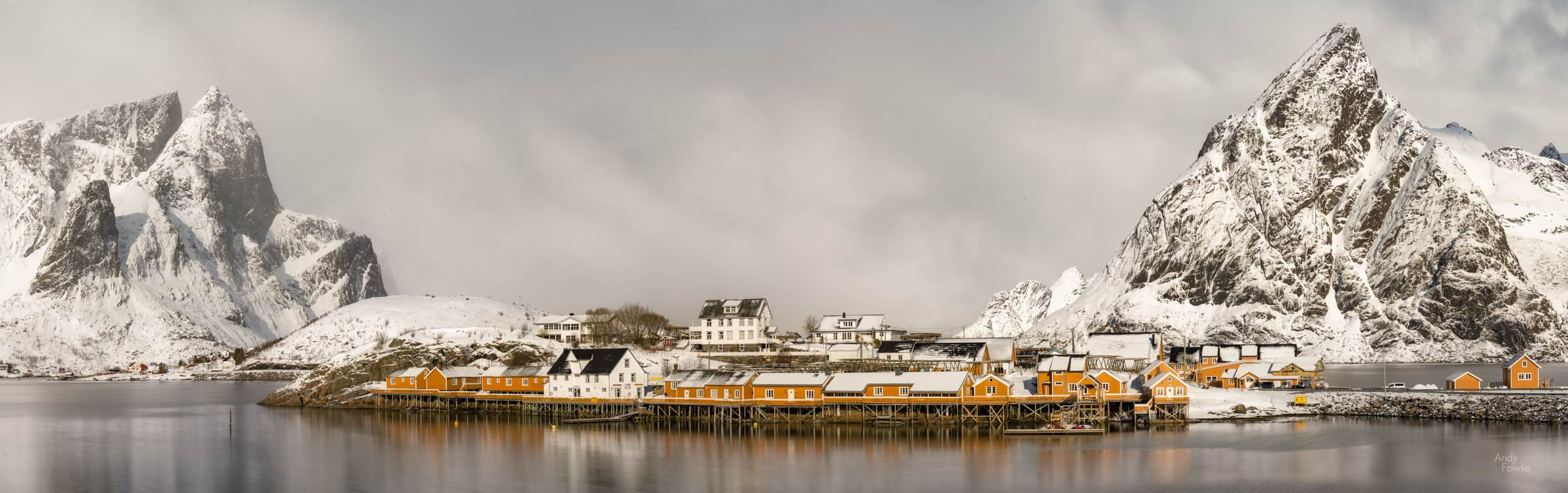 a peaceful but cloudy day in Sakrisøy When I manage to drag myself past Sakrisøy there is only a few hundred metres before it is imperative to stop again for the world famous view of Hamnøy sheltering under its mountain guardian. 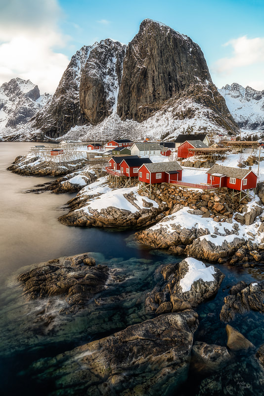 Hamnøy on the rocks The main road which runs through Lofoten is the E10 highway, this 850km long highway runs from Luleå in eastern Sweden all the way to the end of the line at the village of Å in Lofoten. After Å there are many kilometres of mountainous terrain, but there are not many people and no roads. 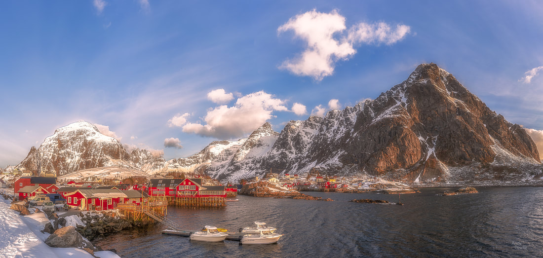 the morning sun arrives at Å - the end of the line Lofoten is also are great location for beach photography, providing everything that you might usually want to photograph at a beach, but with the added bonus of a mountainous backdrop. The most imposing of Lofoten's beaches (in my opinion) is Uttakleiv, rather a violent place on the more exposed side of the surrounding mountains with a rocky shore and a mountain backdrop. The feeling of the place is enhanced by the warning signs predicting dire consequences for anyone caught in a rockfall. 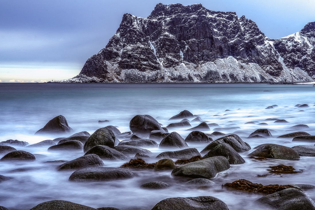 the rocky shore at Uttakleiv When you pass under the mountains through a short tunnel to reach Haukland beach you are suddenly in an oasis of comparative calm. Haukland is a massive flat sandy beach gently curving around a large bay. It is a wonderful place for a walk along the sand, observing the oystercatchers as they forage in the surf. 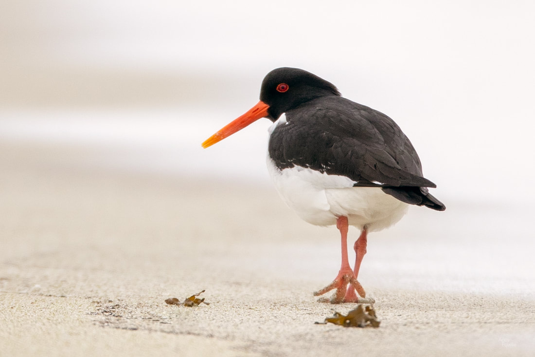 An oystercatcher enjoys an afternoon stroll Although Uttakleiv is the most wild and Haukland is the most peaceful, Skagsanden beach is simply my favourite. Skagsanden is a gently sloping sandy beach with a nicely shaped mountainous background. The bay is shaped in such a way that it is both sufficiently interesting and sufficiently safe to attract intrepid arctic circle surfers to test their skills.  surf's up at Skagsanden On this particular afternoon I would say that the surfer might have been having more fun but the Oystercatchers were having more success as the tide revealed a number of tasty snacks.
A few kilometres along the road from Skagsanden beach there is a turn off which takes you to the village of Nusfjord. It may not be a total surprise to hear that Nusfjord is a small fishing village surrounded by mountain peaks.  looking down onto Nusfjord harbour Nusfjord is also home to a good selection of seabirds, with the black-legged kittiwake being by far the most noisy of all the villages residents. Its difficult to imagine what meaning their seemingly constant screaming must have but I can only suppose that their communications must rely on the meaning of infrequent silences rather than the meaning of shouting the same words again and again... unless their culture is based on an avian variant of Kabaddi. A more welcome sight from my point of view was a single European Shag swimming around near the harbour, a cormorant-like species that I had not seen or photographed before. 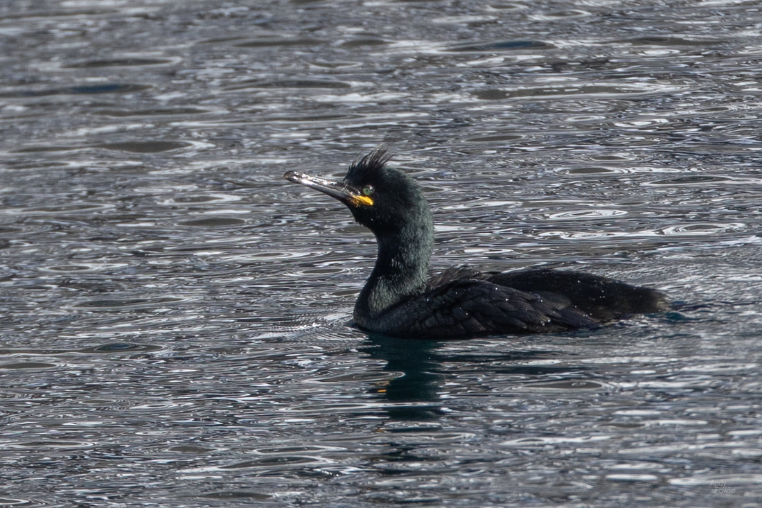 a European Shag Driving back from Nusfjord to Reine should be a relatively simple 40 minute drive, but that theory never holds because you have to pass Skagsanden...  a moody afternoon at Skagsanden beach ... and Hamnøy.... 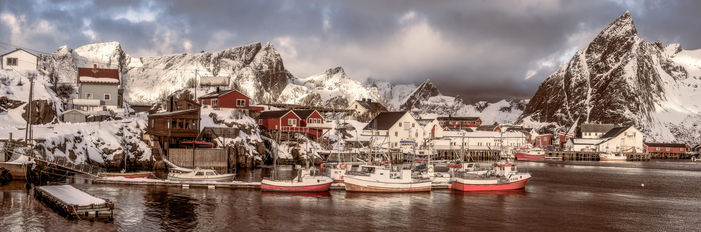 boats in Hamnøy harbour ... and Sakrisøy... 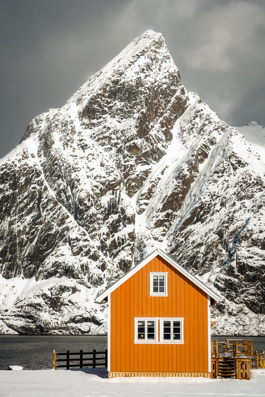 a lonely cabin in front of the mighty Olstinden mountain ... before you finally get to Reine. For some reason Google maps does not take this into account when calculating the driving time. Even when you get to Reine there can be many photographic temptations in the way before you finally get to your cabin. 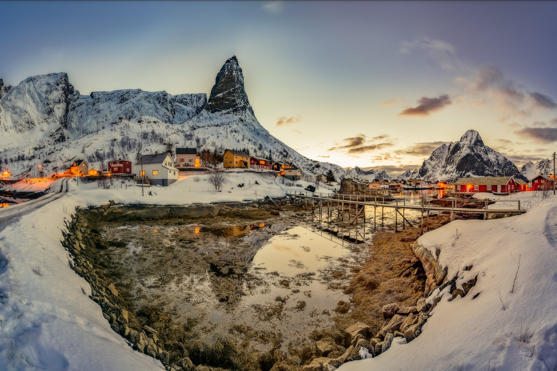 twilight in Reine as an imposing finger of rock juts out from the mountainside behind this small harbour area The early mornings and late nights needed to catch the sunrise and sunset at this time of year soon take their toll, and that makes good coffee extremely important. Fortunately the Bringen cafe provides these lifesaving services with their friendly and welcoming staff, excellent coffee and delicious home baking. Looking at the morning photos with a double latte is a great day to recharge the batteries for the day ahead. Walking around in the villages of Lofoten there is one feature which is immediately obvious to more than one of your senses. The stockfish racks, filled with thousands and thousands of cod drying in the arctic air, provide an authentic addition to all of your photographs from these villages while also ensuring that you, your clothes, your car and everything else smells faintly of fish for the following few weeks. 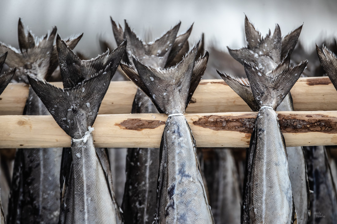 stockfish This local delicacy is a significant business with Lofoten stockfish being sold all over the world, the temperature and humidity being exactly right for this process thanks to the high Arctic latitude being tempered by the influence of the warming gulfstream currents.  the stockfish racks also provide good shelter for quizzical magpies. These villages are also home to large numbers of birds, with different gulls and other seabirds being the most numerous of these along with ducks such as the common eider. I saw white tailed eagles flying overhead at least once per day during my visit. There were also a number of smaller birds such as house sparrows, rock pipits, bohemian waxwings and snow buntings. 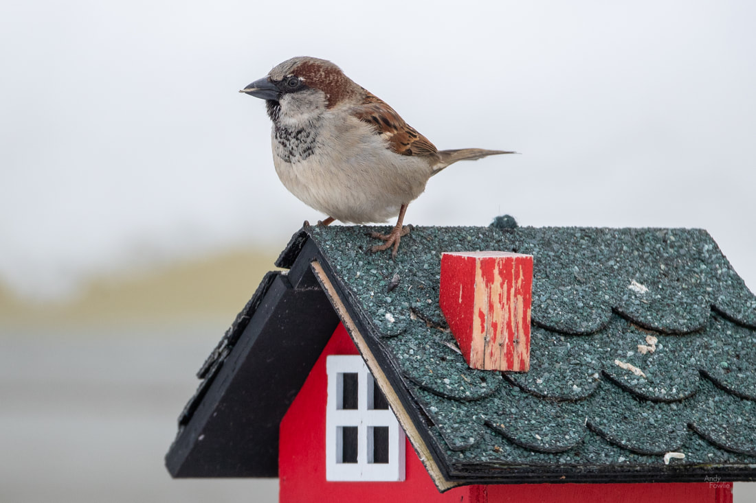 this is a house sparrow... as it was obviously trying to tell me. 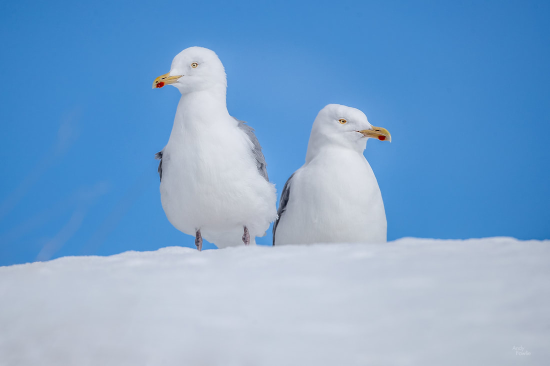 a pair of gulls... maybe lesser black backed gulls. All too soon, it was time to leave Reine and head back towards my home in southern Finland. I decided this time to drive the whole way (previously I have allowed ferries or trains to do part of the work) in order to see how easy it was to make the journey in that way. Doing this also allowed me to make many stops on the way... 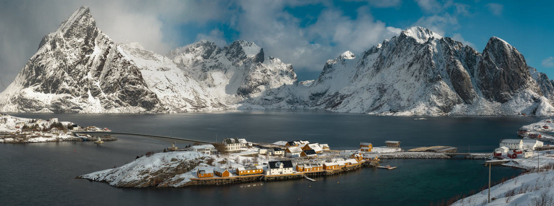 Sakrisøy, from Olenilsøy 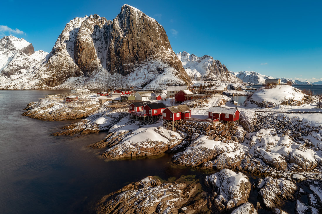 beautiful Hamnøy 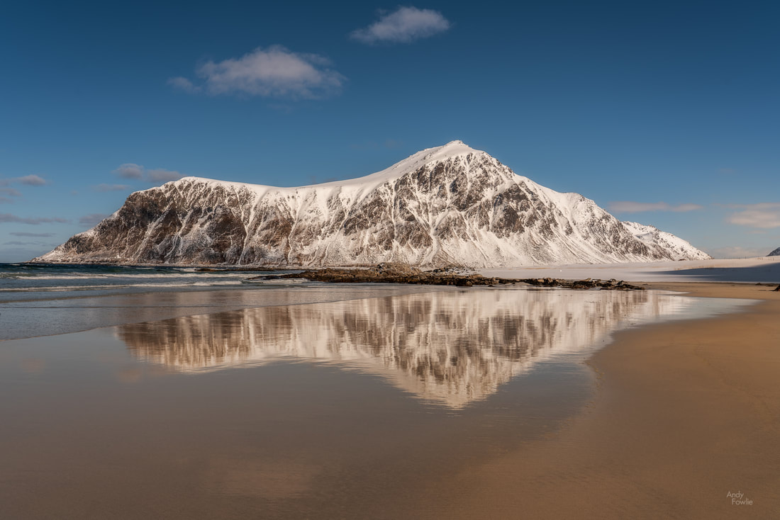 peaceful Skagsanden In order to get back to the mainland, you first have to drive north along the whole length of Lofoten. I took the scenic route rather than the direct route, hoping to check out the area around Gimsøy... which took me past this view near to Valberg - a welcome surprise.  Valberg reflections As my journey continued, I started to look out for a place where I had encountered a white-tailed eagle sitting on an electricity pylon 13 months earlier. These birds will often have favourite perches within their territory so I thought there might be a chance... and sure enough I was in luck. 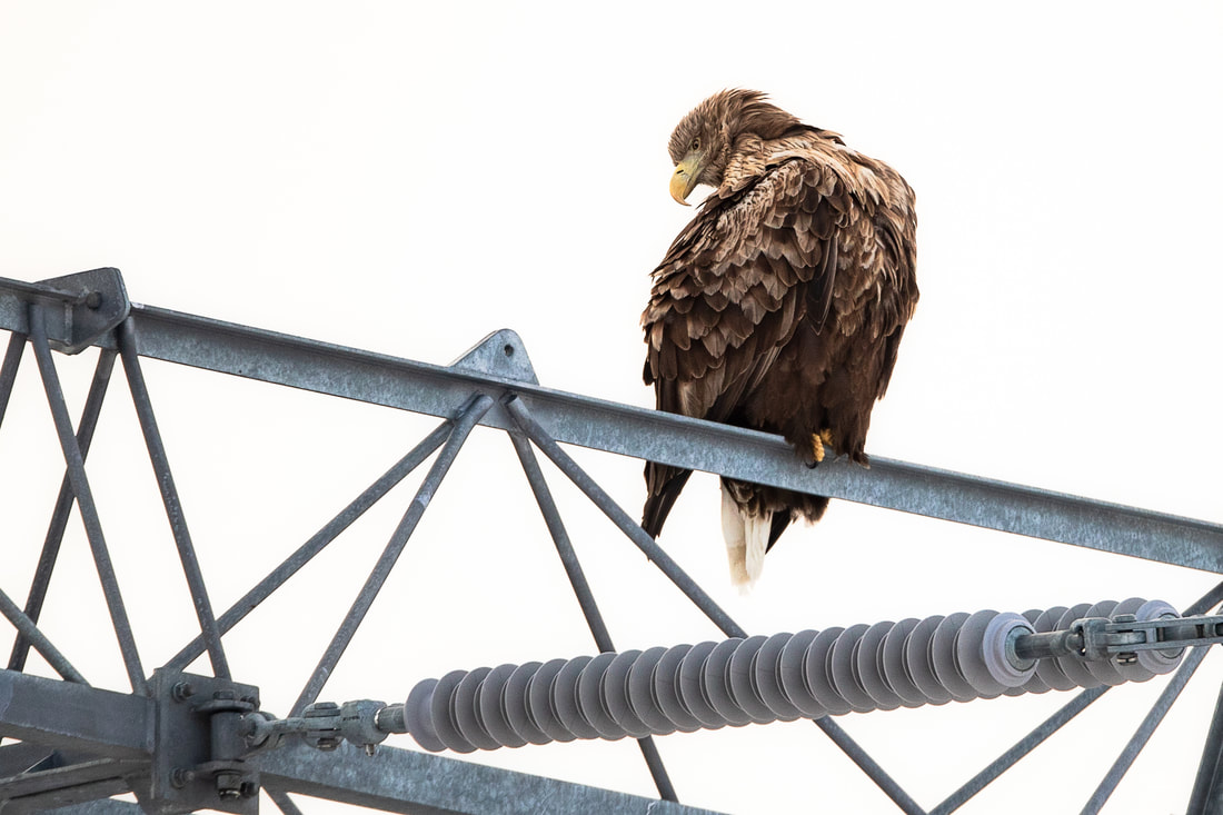 an adult white-tailed eagle The final shots from this trip came on the outskirts of Svolvaer, I stopped to try and find a good composition of a row of houses only to find that they had been obscuring a single house on an island which I liked even more. 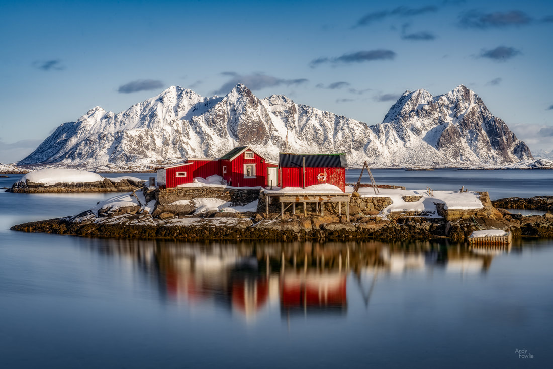 an island residence, outside Svolvaer. Once again, it was a huge pleasure to spend time in Lofoten. I enjoyed every minute of it. Mostly the weather was not quite optimal for photography, oscillating between too good (cloudless skies and harsh light) and too bad (low visibility and featureless cloud) with a shortage of dramatic sunrises and sunsets , but that is just how it goes, sometimes you get lucky and sometimes you don't. Now that this blog is published its time to plan the next trip... lets see where the next blog comes from! Andy Recent postsMy latest trip, to the Berchtesgaden area of Germany, was a return to the beginning in a number of ways. This magical area, with spectacular alpine scenery and the vertical elements that I always look for in my landscape photography, was the venue for my first ever photography trip back in April 2016. I was so taken with the place that it was also the venue for my second ever photography trip back in May 2016. Germany itself has long been a favourite country of mine. I lived there for about three years when I was very young, leaving when I was three and a half, which may have something to do with it, but I also spent a lot of time there while working with great colleagues from our Ulm site in the Nokia days. For whatever reason, the country as a whole is a comfortable destination for me, and the southern part of Germany is somewhere that I just love to be. 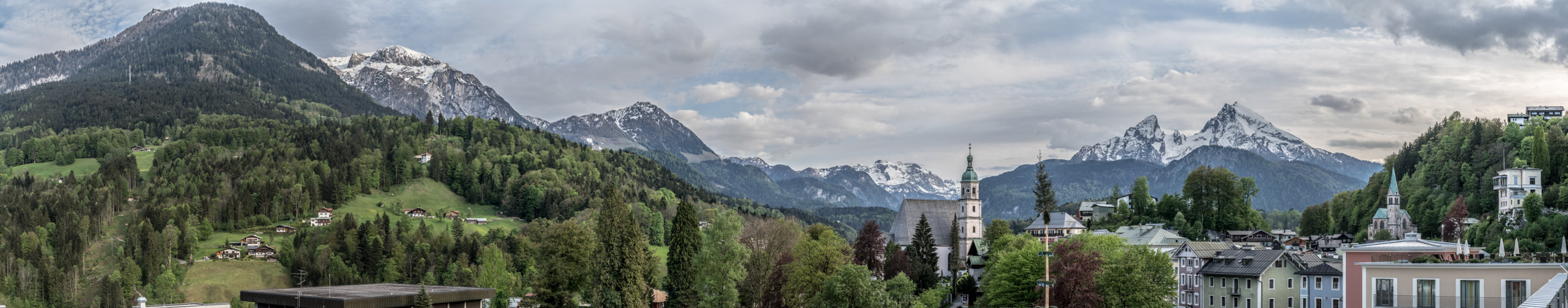 The rooftops of Berchtesgaden (May 2016) from the roof of Hotel Edelweiss The town of Berchtesgaden, at an elevation of about 700m, rests in a valley surrounded by spectacular hills and mountains. The area has rich salt deposits which made it an important town, changing hands between various countries in the conflicts of the 19th century. For my purposes it is a perfect base for a photography trip as it is in the middle of an area which is filled with amazing sights. Within 15 minutes you can be on the shore of the beautiful lakes at Königsee or Hintersee, at the foot of the cable car to Jenner (1876m), looking at the beautiful Maria Gern Chapel, exploring the gorges at Wimbachklamm or Almbachklamm, or driving up Rossfeldpanoramastrasse for amazing views of the surrounding scenery.  the Jennerbahn cable car (May 2016) Visiting the area in November is something of a gamble when it comes to the weather. I had been watching the forecasts closely and it seemed that the weather would be a mixture of cloudy and clear days with temperatures fluctuating either side of zero. This sounded pretty good to me, there may be a chance to capture the area covered in the first snow of the winter and there could be a balance between periods of capturing new shots and other periods of going through the results. It was definitely the off-season for the locals, the hiking and summer tourism season was well and truly over, but the skiing activities were not yet up to speed, and that also showed in some of the attractions - the Jenner cable car was out of action for maintenance and the gorges were just open routes rather than being staffed as they are in summer. My biggest hope for the trip was to get an updated and improved shot of the Maria Gern chapel. This has been one of my favourite places to photograph since the moment I first visited it in April 2016. The beautiful chapel, perched on a hillside, with the road curling round it in an s-bend, and the crowning glory of the iconic Watzmann mountain in the background. My best picture from there in 2016 was taken at night, capturing the headlight trails with a long exposure.  Maria Gern 2016 I hoped that during the trip I might be able to enhance this shot with snow, stars, more headlight trails, sunset/sunrise colours or many of those. Getting such an opportunity would require some persistence and also some cooperation from the weather. On the afternoon of my arrival I headed for Hintersee, a fairly small lake surrounded by mountains, with a level path winding its way around the shore, a fantastic place to go for a walk in any season. On this occasion, in a pattern that was to persist through the whole trip, the clouds were almost constantly too low for the mountains to be visible. I had to make do with occasional glimpses of mountain through the clouds.  now you see me, now you don't My accommodation for the trip was the fantastic Hotel Edelweiss in Berchtesgaden. I have stayed there three times now and it is just about perfect. The family run hotel is in a prime location in the middle of Berchtesgaden and has direct access from the very convenient and not very expensive underground parking. The rooms are generous, clean and well taken care of. The breakfast is sensational. The service is always polite and helpful, and there is a great pool and spa area. Considering all these things, the price is very reasonable. I would highly recommend it to anyone, but please don't all go there in case the prices go up and it makes it harder for me to get a room next time. While Maria Gern might be my favourite place to photograph in Berchtesgaden, my favourite place to be might be Rossfeldpanoramastrasse - a toll road which lets you ascend from the valley floor (700m elevation) all the way up to the top of Rossfeld (just under 1600m elevation) via a series of hairpin bends. This is a real pleasure to drive, and it offers spectacular views, to all directions, both of Germany and across the border into Austria. On a clear day you can easily see Dachstein in the distance, some 70km away. On this trip however, the visibility was often closer to 70m than 70km.  what a view! Over the next days, the weather failed to live up to the forecast, the clear spells did not arrive and the temperature did not go low enough to allow snow at the level of the valley floor (there was however an abundance of rain). I tried to find some breaks in the weather, moving between places and also changing elevation in case there was a way to get under or over the clouds, but it seemed like there was no relief. I realised that all the things I had in my mind to photograph on the trip were impossible without visibility of the mountains. This was pretty frustrating... but all I could do was keep trying and hope for a break in the weather. On the third evening, there was finally a short window of opportunity, as the clouds lifted higher than the mountains for about 25 minutes in the period after sunset. Luckily I was ready for this at Maria Gern, and tried to capture a longer exposure image with the headlights of multiple vehicles coming and going. 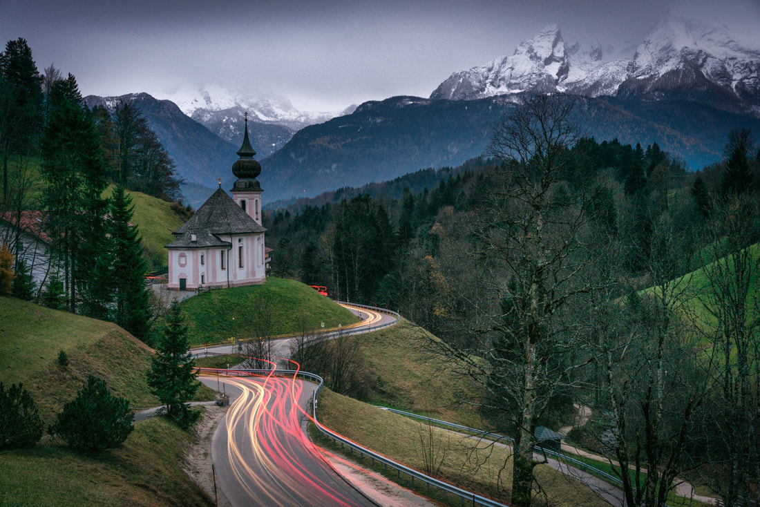 Maria Gern on a moody evening - 20 minutes exposure This was at least something... but the dark and moody weather makes it very hard to get attractive colours to an image like this. The following day there was another short weather break, this time while I was near the summit of Rossfeld. The clouds were split, below 1400m there was no visibility and there was also cloud cover above the mountains, but in-between there was a window of partial clarity and the impressive Göll massif (the highest peak being Hoher Göll at 2522m) was visible from Rossfeld for the first time during the trip. 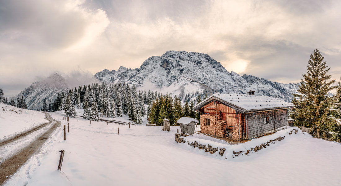 A log cabin on Rossfeld, in the shadow of Hoher Göll At Hintersee there was an improvement in visibility also as the surrounding peaks came into at least partial view, but still the featureless grey skies were ever present. Those characterless expanses of grey do rather limit your options for making beautiful images.  Hintersee panorama  Hintersee misty mountains That evening another small weather window opened after sunset, and it was possible to see through the cloud blanket at Maria Gern for the first time in the trip, for about 25 minutes before the clouds gathered again. 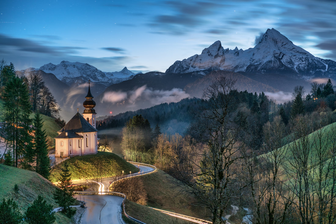 twilight at Maria Gern That night, finally, the first snow of the winter arrived to the lower elevations in the Berchtesgaden area. As usual on these trips, I was up and out at about 0530 - around 90 minutes before the sunrise. I headed for Maria Gern, for maybe the 10th time in the trip, hoping to find it blanketed in perfect fresh snow and also dreaming that the Watzmann mountain would be visible. As many in Finland can recognise, the day of the first snow is the trigger for everyone to forget how to drive, this manifests in many ways but the main ones are to drive far too cautiously and to drive nowhere near cautiously enough... both things being relative, each of us has the luxury to place ourselves somewhere in-between at the "just right" point and observe how everyone else gets it wrong.
Early that evening, back at Maria Gern for the umpteenth time, the skies were at least more interesting, with many shades of grey instead of one, but the mountains were still not visible. 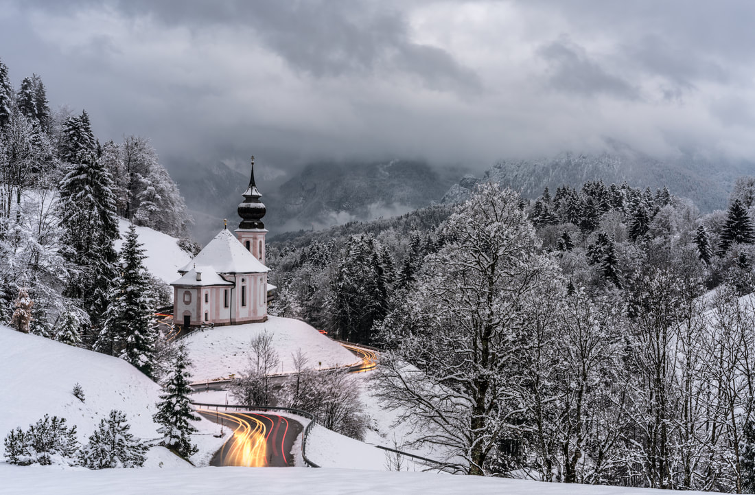 Angry skies at Maria Gern At this stage, the trip was starting to feel like a disappointment from photography point of view, the mountains had been visible for a total of about 90 minutes during the past 120 hours, and I had not really been able to make much progress. There was one night left, and then possibilities to shoot until lunch time before heading back to the airport. Last chance. The final morning was a a beautiful one, but the world was still shrouded in cloud - the cloud was however white rather than grey and looked like it might burn off as the morning progressed. I headed to Maria Gern once again, hoping that the sky would clear to reveal the mountains as the sunrise approached. Once again this was a frustrating morning... 2 hours on top of a hill in temperatures below zero... above me I could see clear blue sky, behind me I could see the first rays of the sun hitting the Untersberg mountain but ahead of me a bank of cloud obscured the view behind the Maria Gern chapel. Disappointed, I headed back for breakfast. The Edelweiss breakfast lifted my spirits somewhat as I sat with my back to the window and thought about what time I would need to leave to get back to Munich airport. After eating an enormous breakfast I turned to check the weather - it was stunning. The clouds has burned away and it was a beautiful day. I hurried to pack my things and checked out in a terrible rush before making my final visit to Maria Gern where a fairytale scene awaited me. 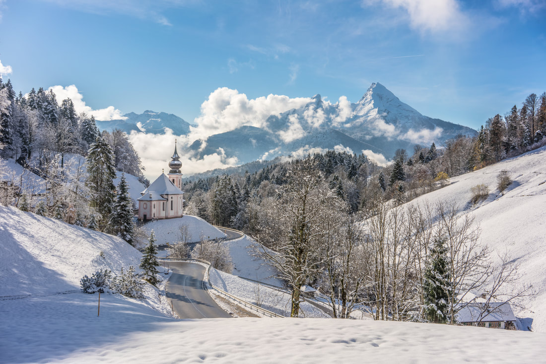 Like a fairy tale... 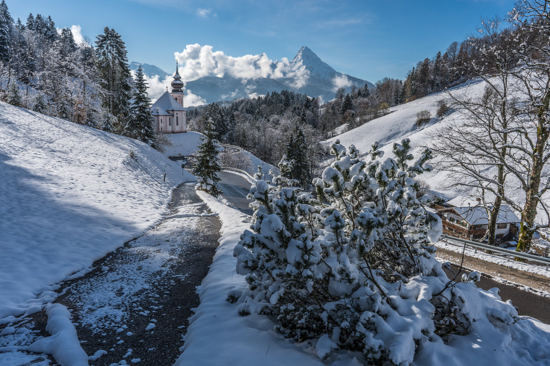 I wish this was my front path... After drinking in the beautiful view for a while, and taking many photographs, I realised that my wallet was not in it's usual place. I guessed it would be in the car and carried on. Returning to the car, it became apparent that my wallet was gone... along with my credit card, drivers license, etc. This was not good. I retraced my steps... fortunately it was not a long trail. I had the wallet when checking out of the hotel, then I went to the lift (10m walk) and descended to the car park before driving to Maria Gern. I double checked my route at Maria Gern and also triple checked the car before calling the hotel and driving back to the car park... where I found my wallet and all its contents. It had been lost for about 80 minutes. No harm done, but I do not recommend anyone else to try this experience. After this unplanned detour I had about 2 hours before I had to leave for the airport. I returned to the summit of Rossfeld where the fresh snow and beautiful blue sky combined to make it a place of amazing beauty. There is no better place to be than in the mountains when the weather is like that.  Dachstein comes into view, above the clouds in centre-right of this image  Rossfeld ski centre (lower right) with the Untersberg obscured by clouds (top middle) as seen from Rossfeldpanoramastrasse  the Salzach valley, surrounded by the foot of the Göll massif (front right), the Tennen mountains (back right) and Dachsteinn (back centre)  frozen firs  snowy details It was a fantastic way to conclude my trip, in such beautiful conditions at one of my favourite places.
As with my other November trip, to Iceland, it had been a pretty challenging trip, with a lot of time and effort needed to squeeze out comparatively few good photographic opportunities, but once again I loved being in Berchtesgaden despite the difficulties. It is usually the case when dealing with landscape photography, that you are at the mercy of the weather conditions to some extent... occasionally you hit the jackpot, but often you are limited in your options. All you can do is be in position and ready to take advantage of any opportunities that come your way, and keep your eyes open for possibilities that you didn't consider in advance. Now I need to try staying in Finland for a little while, at least long enough to sort out the insurance claim from my Iceland trip equipment accident, and then consider what my best options are for this time of year, I need to find destinations that are less weather dependant and subjects that are possible to work with regardless of poor visibility, the 2017 mountain photography season seems to be done. Until next time! Andy Normally I prefer to be flexible in my arrangements, and don't require much pre-planning... but even for me deciding to go to Iceland with less than 20 hours notice was a bit last minute. The weather in Finland was depressing, and not having made an early appointment for changing to winter tyres meant that I was somehow limited in what I could do... so I decided that it was time for another trip. Flights and accommodation were checked for a number of places that were on my to-visit list and the decision was made - I left for Iceland the following morning.  Despite booking at the last minute, it was surprisingly easy to find affordable accommodation. I have seen many pictures from Iceland, and some of my photographer friends speak about it in the same terms that I refer to Lofoten, as a photographic paradise, but I had been holding off on booking a trip there... somehow unsure about how (and when) best to do it. I decided that it would be best to stop procrastinating and just go there, thinking of it as a scouting trip, with an intention to learn as much as possible so that I could make a proper plan for the next time. The first time visiting a new location has the benefit of maximum excitement due to everything being new, but the penalty of a lot of time spent finding out which places best capture your imagination and how things work in that destination... the second time often delivers the best results from photography point of view, at least for me. My plan for the trip was to follow highway 1 round the entire southern coast of the country as far as the town of Höfn (about 450km), and then return by the same route, stopping overnight on the way at Vik and Hali and at Hali and Selfoss on the way back. As I landed in Reykjavik, the weather was pretty disgusting... extremely windy and pretty wet. The temperature was about 5 degrees, but with the wind and the moisture in the air it was really cold. Soon enough I was on the road, stopping at the spectacular waterfall of Seljalandfoss on the way to Vik. 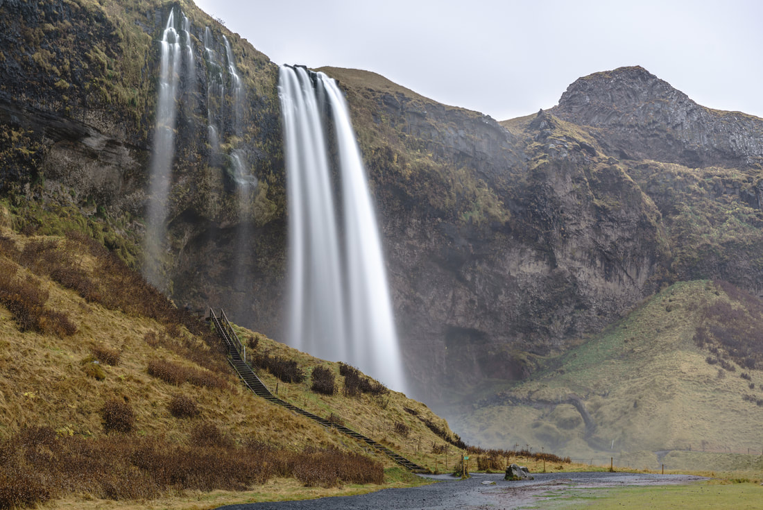 the waterfall at Seljalandfoss Seljalandfoss is the first of many spectacular cascades that you can see from the highway as you make your way around the island, and it was absolutely packed with tourists, even on this rather ugly day in the off season. It may look deserted in the picture above, but that is due to the magic of a very long exposure... as long as the people are moving it is possible to turn them into ghosts with an exposure of many tens of seconds. One special feature of this waterfall is that you can walk behind it, opening up some great angles for photography, but in this kind of weather, with the wind blowing all the spray towards you, it was impossible to make any use of those possibilities. The town of Vik, with the nearby Reynisfjara beach, was my next stop. Reynisfjara is a beautiful but dangerous location, the black sands, basalt columns and interesting sea stacks providing the beauty, while the possibility of "sneaker" waves (suddenly coming 10-15m further up the beach than all other waves) provided the danger. After a gently sloping start to the beach, it drops away very rapidly, and if one of those waves catches you there is no getting back... the next landmass to the south is Antarctica. By this time the weather was truly horrible, and the sea was wild, the chances for any sunset colours were replaced with a selection of thunderous greys. 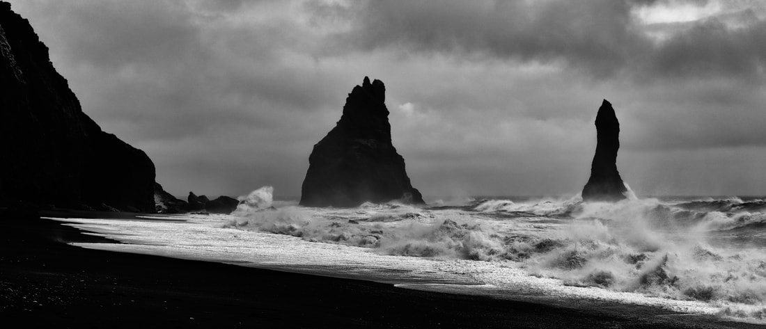 a dirty day at Reynisfjara beach The next day was brighter, but no less windy. The wind was strong enough to be a real problem for photography, even a comparatively heavy tripod could not keep the camera still reliably and many attempted pictures were ruined by the vibrations. I had studied the weather forecast before leaving, but had been more interested in the the rain and cloud than I had about the wind. The geography of the southern coast of Iceland is such that the mountains, volcanoes and glaciers that make up the interior of the country are bordered by extremely flat and exposed plains, and there is very little natural shelter.  the church at Vik, 2 hours before sunrise 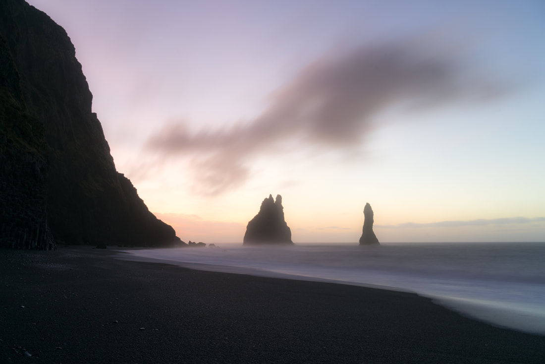 A dreamy sunrise at Reynisfjara After leaving Vik, I started on the journey towards one of my most anticipated locations, the glacier lagoon at Jökulsárlón. I expected the journey to take a couple of hours, but it is quite difficult to make good speed on the Icelandic roads because you end up stopping every few kilometres when the next amazing sight catches your eye. The 90km/h speed limit and occasional one-way-at-a-time bridges on the highway also limit your progress. I alternated between stopping (and feeling like I should get going again) and driving on (wishing I had stopped) for much of the morning, the waterfall at Foss á Siðu being one of the places where I was happy that I did stop. 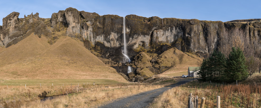 Foss á Siðu Thankfully I managed to keep going forward sufficiently to arrive at Jökulsárlón Glacier Lagoon with a couple of hours to spare before sunset. This is a truly "out of this world" destination, a place that takes your breath away. The massive Breiðamerkurjökull Glacier deposits its building-sized iceberg offspring into this lagoon, from which there is a relatively narrow and shallow passage to the ocean. The icebergs therefore need to melt significantly before they can escape to the ocean, and form an amazing iceberg traffic jam in the waters of the lagoon. These huge and impressive objects come in all shapes and sizes, and colours that range from clear or white through all different shades of blue, with some that are more dominated by dark residue that has been picked up during the relentless progress of the glacier. 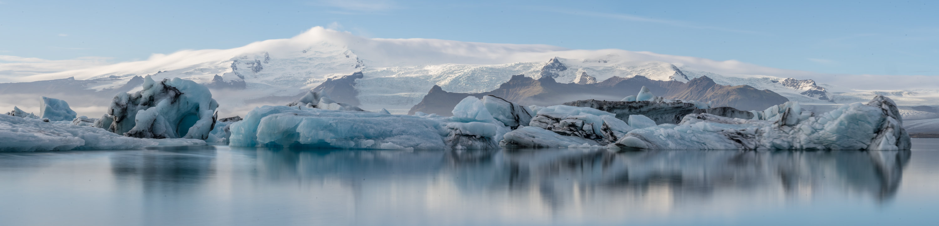 An iceberg traffic jam in the Jökulsárlón Glacier Lagoon. As well as the slowly melting masses in the lagoon, the shores of the lagoon, the channel to the ocean, and the sea shore itself are littered with smaller ice sculptures, some of which are extremely beautiful. Each visit yields a different view as the magical structures are constantly melting, changing and being replaced with new versions.  moonrise and sunset, as some greatly diminished icebergs make their journey to the ocean. 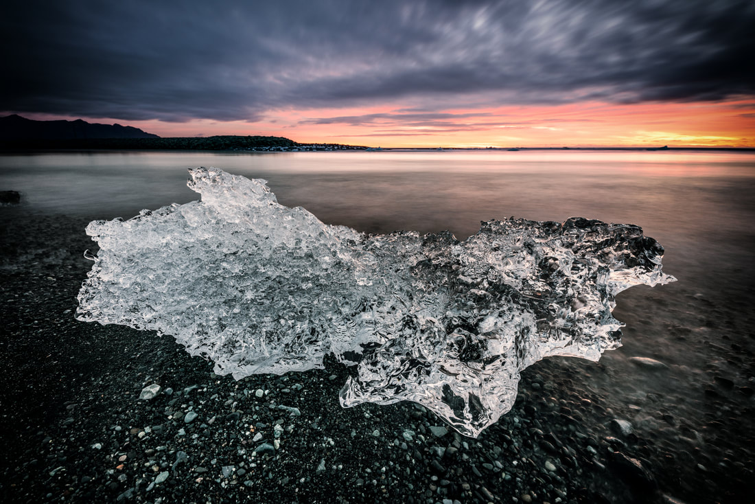 An ice jewel, as the sun rises
The following morning, I spent a long time and walked a number of kilometres in search of icebergs that would meet my criteria. They should be stationary, interesting looking and far enough away from other objects that it would be possible to isolate them in the frame. After a couple of disappointments (one iceberg, which I thought would work well, catastrophically degraded, splitting into two pieces, during a 10 minute exposure... ruining my shot), I found a trio of ice sculptures, about 20 metres off shore, grounded on the bottom of the lagoon, and eroded by the tides to create an interesting illusion that they were balancing on the surface of the water. One 306 second exposure later (I aimed for 300 and got a bit sloppy with my timing) I had the shot I was after, by far my favourite shot from the trip. 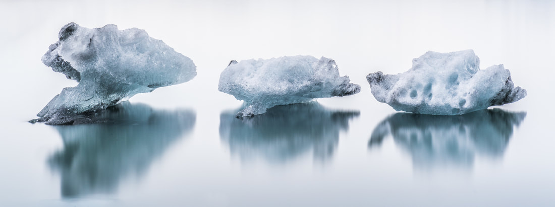 "the brothers" - three icebergs reflected on the surface of the lagoon After departing from Jökulsárlón, I headed for the less famous Fjallsárlón Glacier Lagoon a few kilometres up the road. This was also a spectacular location, with possibilities for better views of the glacier that fed the lagoon and also greater proximity to the mountains. 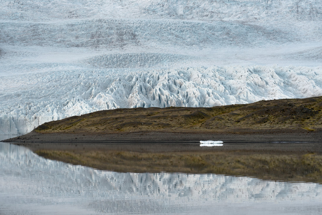 "hiding from mom" - an iceberg is sheltered by the headland with the mighty glacier in the background My journey continued towards Höfn where my intention was to photograph the iconic Vestrahorn mountain, a set of jagged peaks that were conveniently located such that you can picture them with many different interesting foregrounds. When viewing pictures from Iceland I had always been most taken with the Vestrahorn as a subject, the most classic views from there being with the grassy volcanic sand in the foreground, or with a reflection in the waters of the bay. I spent two days at the Vestrahorn, but was not very lucky with the light at any point. 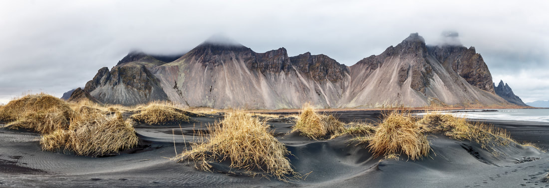 the black volcanic sand with a cloudy Vestrahorn in the background 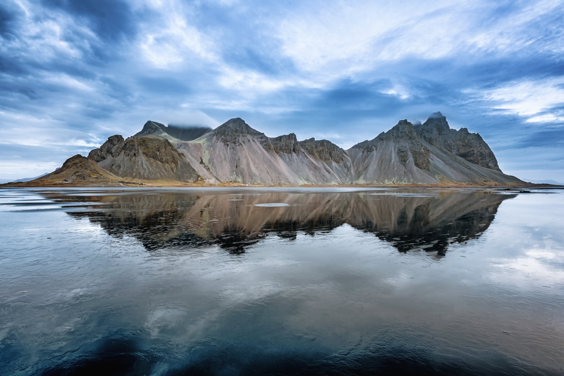 Vestrahorn reflections 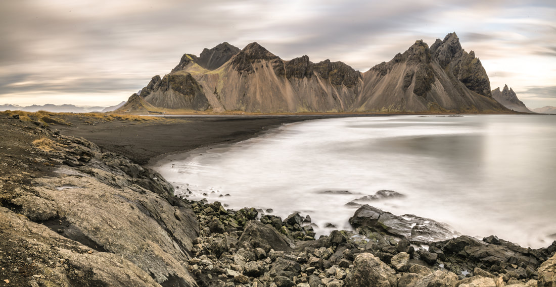 a moody view of the bay Leaving the Vestrahorn behind it was time to re-trace my steps back towards Reykjavik. During my travels I had seen a large number of swans and based on their size I thought that they might be Bewick's swans, a species that I have not photographed before, so I was excited at the opportunity to photograph some at the roadside. A quick google, and a look at the pictures, soon told that they were in fact Whooper Swans (Finland's national bird), so I was denied the possibility for species number 166 of 2017. Nevertheless, it was nice to be able to photograph the Whoopers in typical Icelandic autumn colours (even though the longest lens I had with me, at 85mm, was not ideal for the task).
My next stop on the journey was to revisit the glacier lagoon, and it was there that things took a turn sharply for the worse. I was on the beach, trying to find the right composition for a coastline picture. I thought that I had a good idea of the look I was aiming for, but the best angle was proving elusive. I took the following picture... 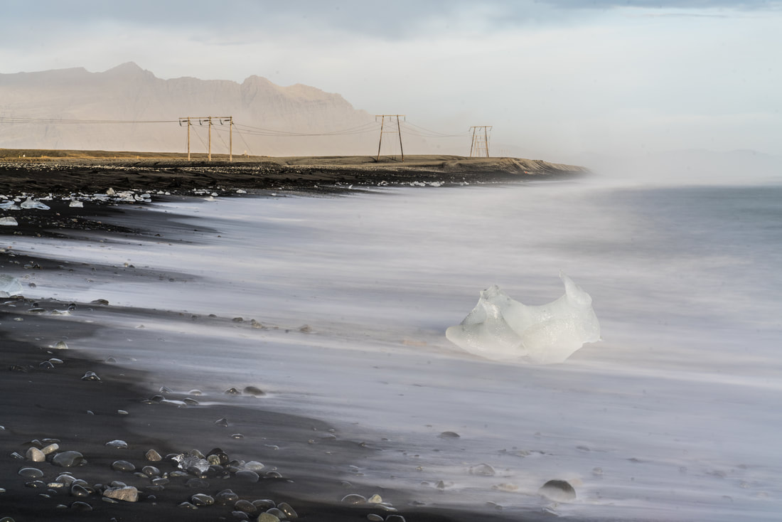 the final act ... and then decided that it would look better if I moved a couple of steps to the right. I repositioned my tripod and was about ready to take the picture when I managed to bump into the tripod, sending the whole package (camera + lens + tripod) tumbling into the surf, the sea having decided to take a couple of steps to the left while I took a couple of steps to the right. The camera was submerged for less than a second... but that was enough... it seems to be totally dead. The picture above was it's final act. I did what I could to try and dry the equipment, and I did have a second camera with me, but the incident was a bit of a shock and it rather reduced my enthusiasm for the rest of the day. The next day, the wind was once again really howling, making photography into a real challenge. The waterfall at Foss á Siðu had no idea of it was coming or going.
A quick stop at Vik allowed for one final shot of the sea stacks and cliffs as the afternoon sun got lower in the sky before I continued around the coast towards Selfoss. 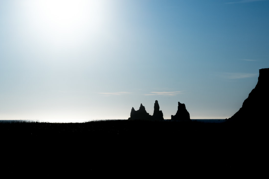 Vik silhouette The last destination on the busy itinerary was the mighty waterfall at Skogafoss, where I hoped to see a rainbow in the spray before the sun disappeared behind the horizon. Once again there were hundreds of people to contend with, but I got there with a few minutes to spare and was treated to a double rainbow. 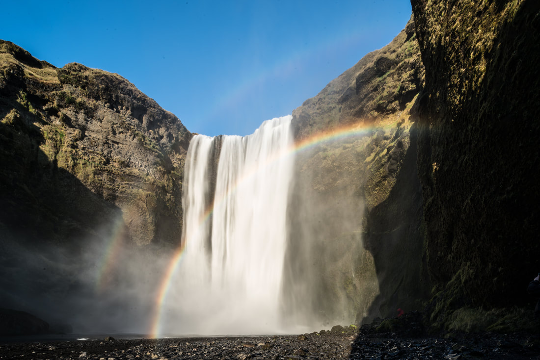 Overall Iceland was a spectacular and fascinating destination, and the trip was extremely memorable, but it was also a very difficult trip. The weather absolutely refused to cooperate (ok... it was November... what did I expect) with the extreme wind being a challenge that I was not able to deal with easily. The accident on the beach, killing my camera and damaging a lens and a tripod was a real low point, and now I get the unwelcome new experience of dealing with insurance claims.
I learned a lot on this trip, and it will be much easier to go to Iceland next time. One thing that I would definitely do differently is to lower my ambitions for covering so many kilometres. There are such a lot of additional attractions between the attractions that you know about that you cannot do justice to the locations when trying to cover too much, especially at this time of year when the days are already quite short. Well, that's it for this time, thanks a lot for your interest in my blog, any comments are most welcome. Andy In the spring of this year I made my first visit to the Lofoten area of Norway, having seen hundreds and thousands of great images shared from there by other photographers. It promised to be a magical destination, and it absolutely lived up to expectations, providing me with a number of good candidates for a portfolio of my best work. On that trip I was accompanied by two photographer friends, Mika Grönroos and Pasi Kaunisto, and we stayed in the beautiful fishing village of Reine, pictured below. 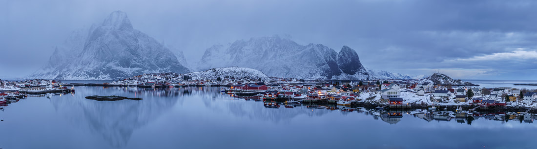 Dreamy Reine - a twilight panorama of this fishing village on a rainy evening Reine was a beautiful location in itself, but it was also a great base for exploring the surroundings, although we did not have to travel far to see more spectacular scenes. Hamnøy, pictured below, was my personal favourite of the locations we photographed. 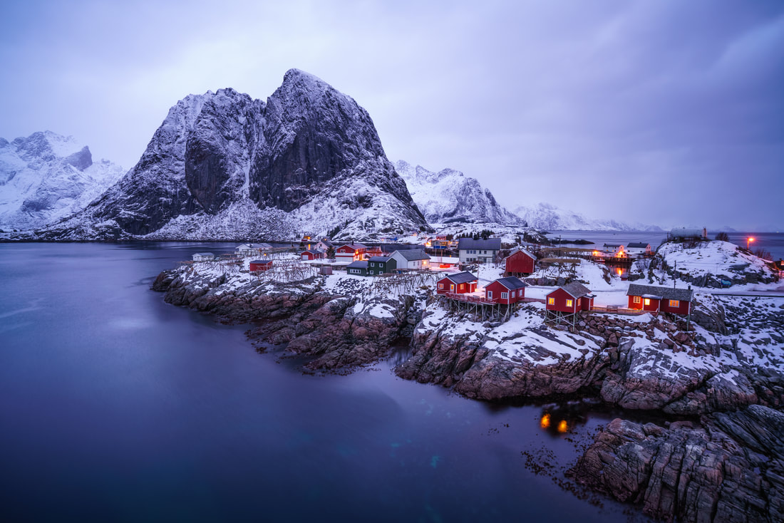 Beautiful Hamnøy - the distinctive red rorbuer (Fishermans huts) on a rocky outcrop in front of the mountains on a cloudy morning before sunrise. The journey from Reine to Hamnøy is a massive 3.2km... and on the way you have to pass through the village of Sakrisøy which is also an unbelievably scenic destination, especially if you climb the nearby hill which has some kind of weather station or other installation on top of it as we did on one morning after the sunrise. While Hamnøy was my favourite location at the time, in the proceeding months I started to feel that the panorama images of Sakrisøy may have been my most successful images.  A contextual portrait of my red Audi A5 - fantastic morning light at Sakrisøy with the snow covered mountain peaks framing the fjord behind Since leaving Reine in March, I have been very eager to return, and plan to do so on multiple occasions, experiencing the changes in scenery brought by the progression of the seasons... this week I will be making the first of those return visits. As I write this I am on the Wasaline ferry from Vaasa in Finland to Umea in Sweden, I will spend the night in Umea before driving about 600km tomorrow to Bodo in Norway in order to get another ferry to Moskenes... which is just a few kilometres from Reine, once again my base for the trip.
There are many different ways to get to Reine, but none of them are particularly fast or easy. In March we journeyed by car-train overnight from the capital area of Finland to Kolari (about 1000km north) before driving for 7-8 hours to Bjerkvik near to the Norwegian border and then driving the remaining distance (a further 6 hours or so) the following day. This time I decided to test the car-ferry-car-ferry-car route, there is also a possibility to fly to Lofoten (from most starting points this requires two flights, one to get to Norway and then a domestic flight to Lofoten) but then you are more limited on the amount of equipment you take with you and have to hire a car. Whichever way you choose, getting there is quite an operation. On this trip the weather promises* to be a bit clearer than it was in March, which is both a blessing and a curse. I really hope to get a chance to shoot some starscapes and to be lucky with the appearance of the northern lights as well as seeing some dramatic sunrises and sunsets, but I might miss the moody scenes that overcast skies can provide, making for potentially interesting shooting even outside the key times around sunrise and sunset. I will remain in Norway at least until 2nd October, and maybe longer, and will keep my blog updated on my progress. Andy * although I recently heard a rumour that weather forecasts are sometimes not 100% correct... |
AuthorAndy Fowlie See also:
SubscribeEnter your email address to receive notifications of new blog posts
Archives
December 2019
Categories
All
|

- Hub
-
Portfolio
- Flow 2019
- magical Vestrahorn 2019
- Fangorn 2019
- a snowstorm at Kintail 2019
- the village 2019
- a bolt from the blue 2019
- peaceful purple pastels 2019
- a Slovenian sunrise 2019
- the cormorant 2019
- Elgol on the rocks 2019
- weeds 2019
- pretty in pink 2019
- Ritsons Force 2019
- Sakrisoy on the Rocks 2019
- the Clappersgate eye 2019
- the Falls of Falloch 2019
- in the jaws 2019
- the devils teeth 2019
- tranquility 2019
- the old man of storr 2019
- Destinations unknown
- Articles
- Recognition
- Contact
- Store
- About
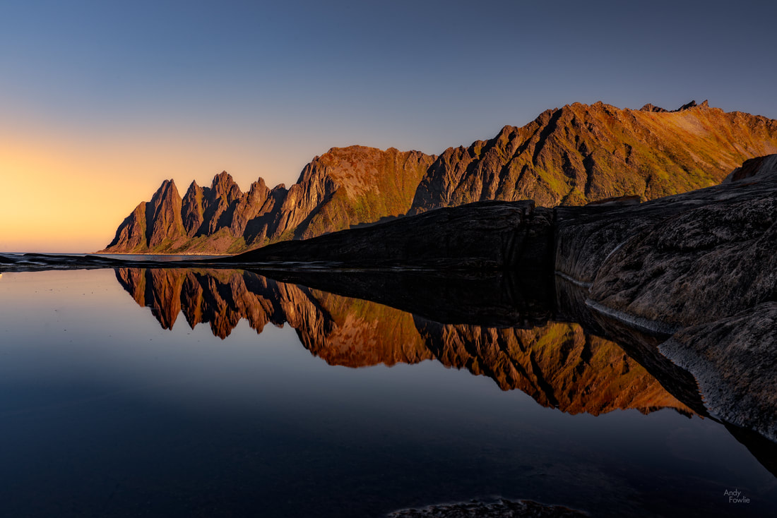
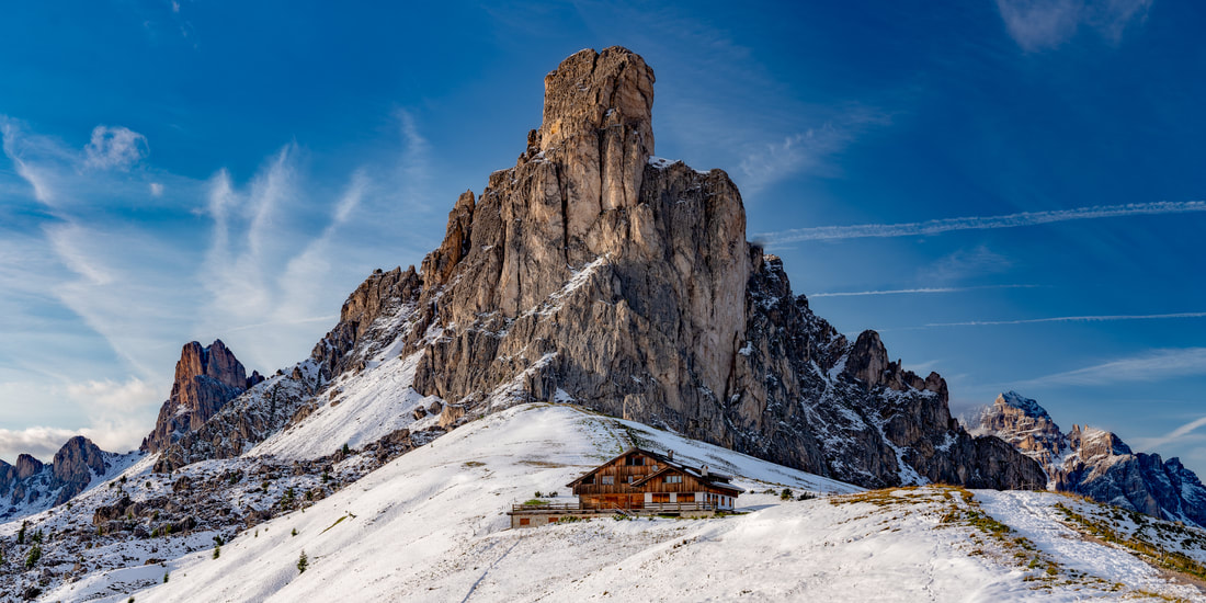

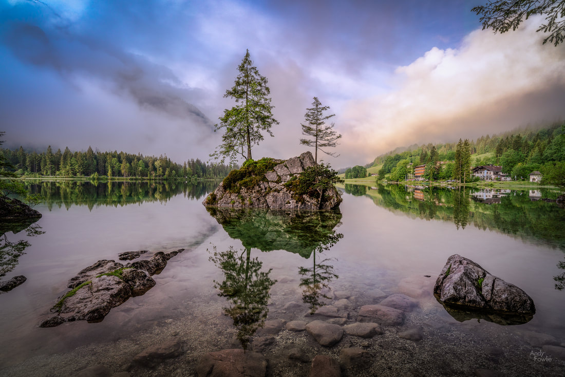
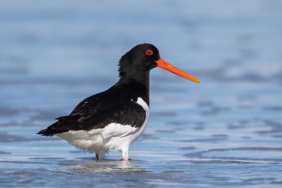
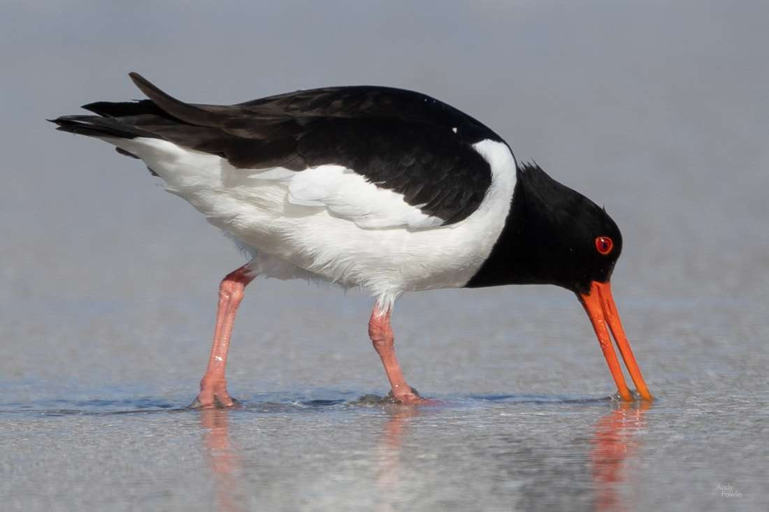
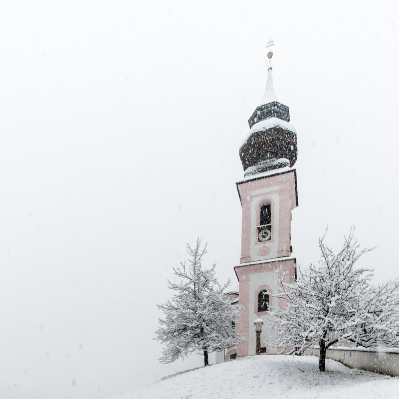
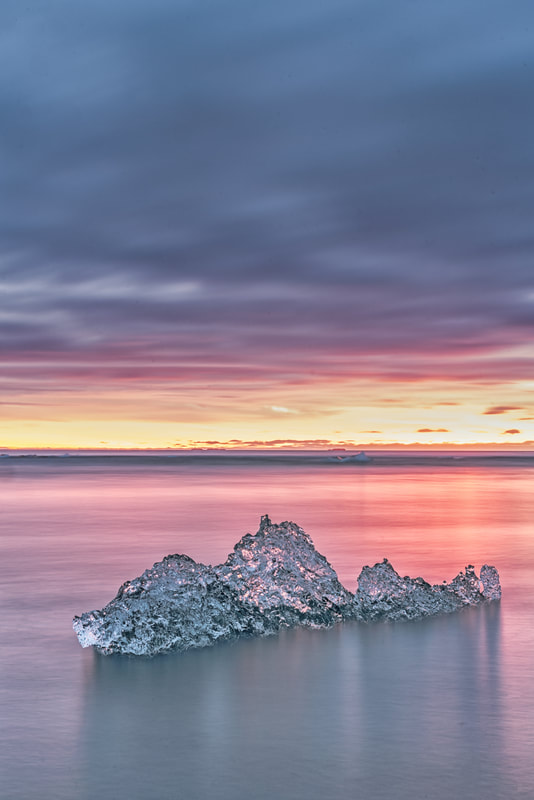
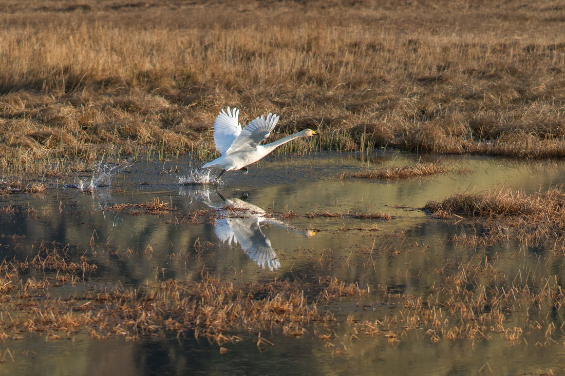
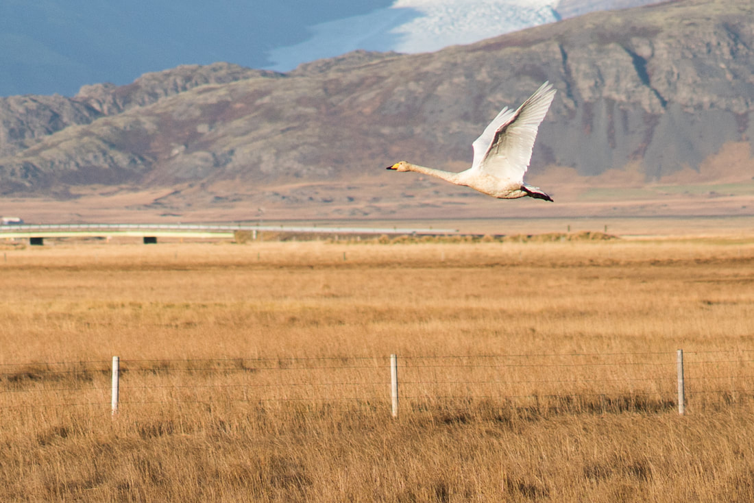
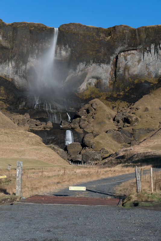
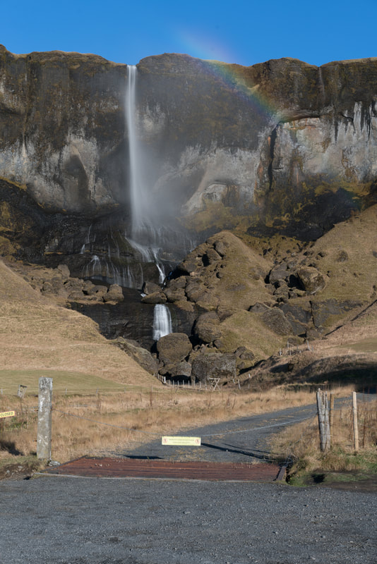

 RSS Feed
