|
I have made many trips to the Berchtesgaden area (in Southern Germany) over the past few years and during those visits I have returned to the Rossfeld mountain on many occasions. It is just a stunning destination.
During my September 2019 trip to Bavaria I stayed for a few nights at Villa Bello in the small village of Oberau, a perfect location for accessing various attractions in the area and especially close to Rossfeld. 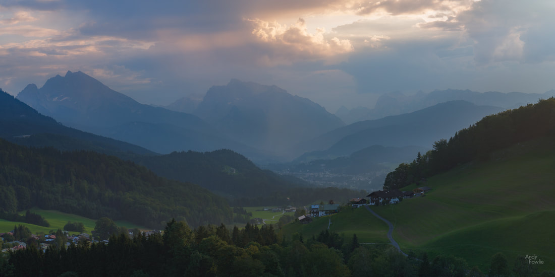
overlooking Oberau as the sun does battle with the late afternoon clouds
At around 1600m the summit of Rossfeld is not particularly high compared to some of the surrounding mountains but it is a fantastic place to visit and has a number of key advantages as a photography location.
The most important advantage is accessibility. The road which leads to the summit is wide, well maintained, safe and easy to drive, with ample parking at the top and multiple stopping places on the way up or down. The road is a ring, the ends of which can be accessed from Oberau (850m altitude) or from Obersalzburg (750m) and you can drive your car all the way up to an altitude of 1570m. 
The view from the summit "all the way" down to the road.
This accessibility makes the destination suitable for anyone who can drive a car or get on a bus, spectacular views can be had in many directions at different points on the route without even leaving the vehicle.
For anyone who has driven on a lot of other mountain roads in (e.g.) Germany, Austria, Slovenia, Italy or Switzerland the Rossfeldpanoramastrasse road is the height of luxury. Perfect surfaces, a wide two-way carriageway, relatively gentle corners and a lack of surprise entrances or blind spots make this a very safe road. For first time mountain drivers a degree of caution should be exercised and special attention should be paid to the speed of travel (especially on the descent). The road is kept in such perfect condition by the collection of a toll, at time of writing access to the road costs €8 for a passenger car. Click here for more information about Rossfeldpanoramastrasse. What can you see from Rossfeld?
The great peak of Hoher Göll (2522m) is Rossfeld's close neighbour (to the south west) and it is a very imposing sight from the top of Rossfeld, appearing immediately adjacent despite being a few kilometres away.
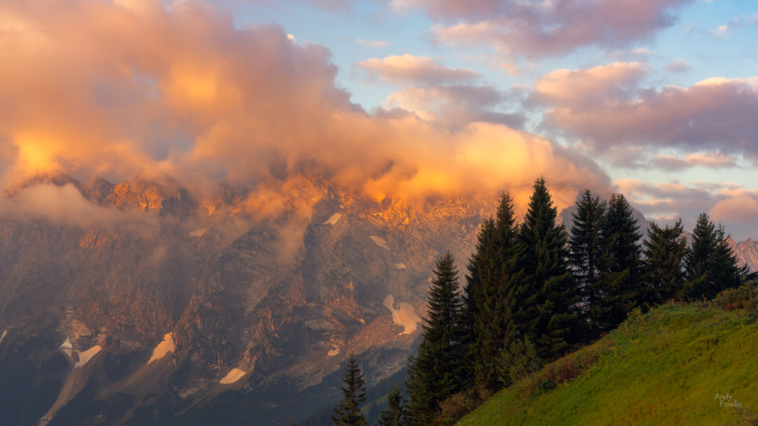
first light hits the clouds that have gathered around the summit of Hoher Göll
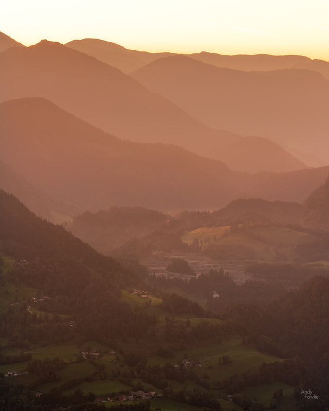
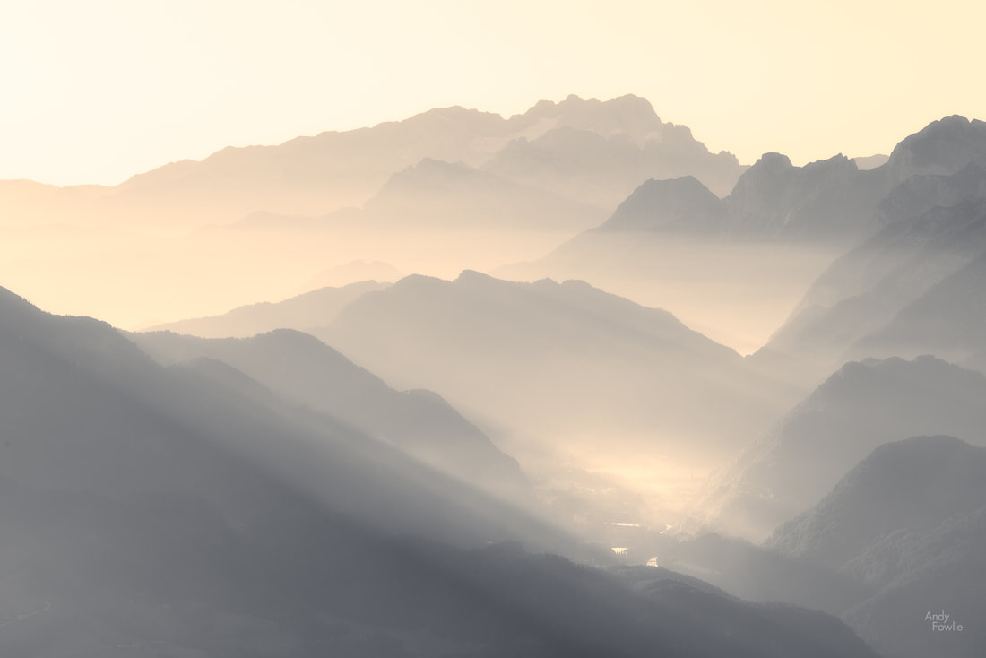
The Göll massif is the first in a sequence of mountain ridges which decorate the landscape in the sweeping views which are available to the south-east from the summit of Rossfeld, following the valley of the Salzach river. On a clear day it is possible to see past the peaks of the Tennen mountains and past the hills from the Salzach valley all the way to the the mighty Dachsteinn (2995m) some 70 kilometres away. On hazy mornings these beautiful layers of mountains are a superb subject for photography.

"the sleeping giants" - first light on a hazy morning with Dachsteinn in the distance
Turning your gaze to the east from the summit of Rossfeld you can get views of the lush valley below with some interestingly shaped hills.
I am sorry sir, sunrise has been completely cancelled today.
This valley is flanked on the other extreme by more mountainous ridges (the Totes mountain range). These views are also stunning although the valley is often in shadow at both sunrise and sunset.
a beautiful morning in the Salzach valley.
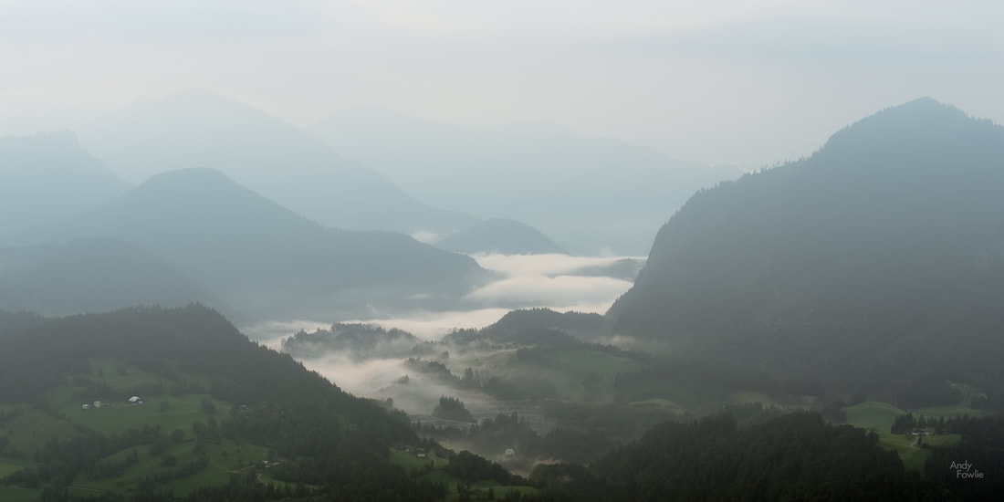
The scenery to the north-east is a little more gentle, a flatter (but not flat) plain with villages and fields, often likely to be covered in fog in the mornings of spring and autumn.
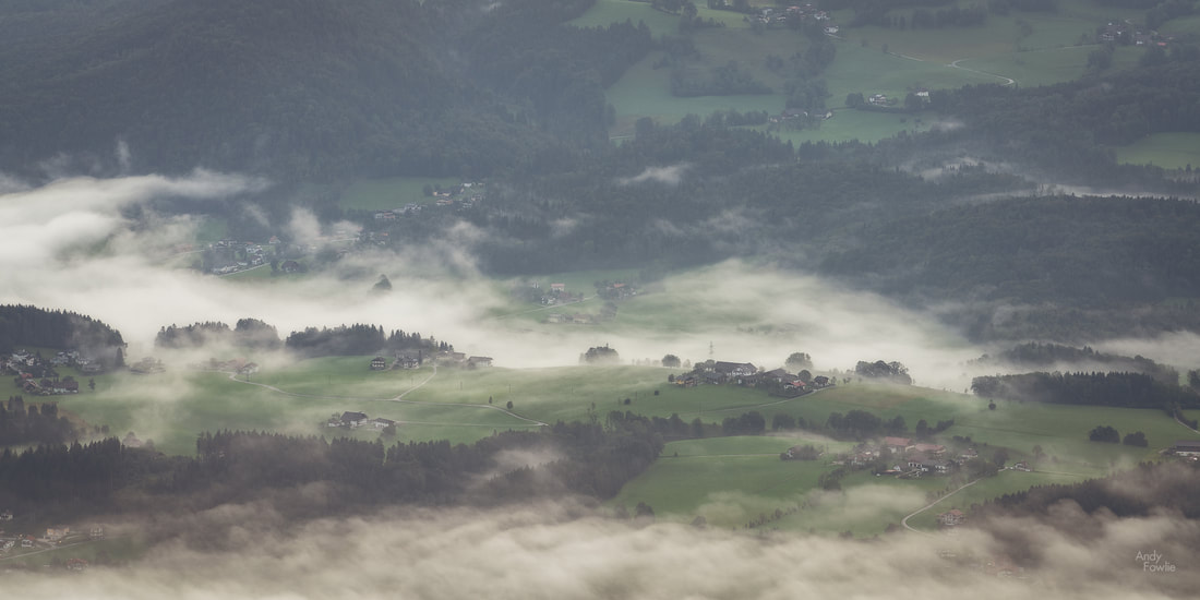
a view from above the clouds
The historic Austrian city of Salzburg lies some 20 kilometres to the north of Rossfeld, and it is possible to catch some distant views of the city, including the airport which is quite easy to identify due to the landing lights. To the north-west you can see a side on view of another huge iconic lump of rock, the Untersberg, topping out at 1973m.
Towards Salzburg (back right) with the Untersberg hiding behind some clouds (November 2017)
As we complete the circle there are views of distant mountain peaks and some glimpses of buildings in the valley below, a highlight is the rounded form of Kempinski Hotel Berchtesgaden which looks like it could be either the new Apple headquarters or the lair of a James Bond super villain.
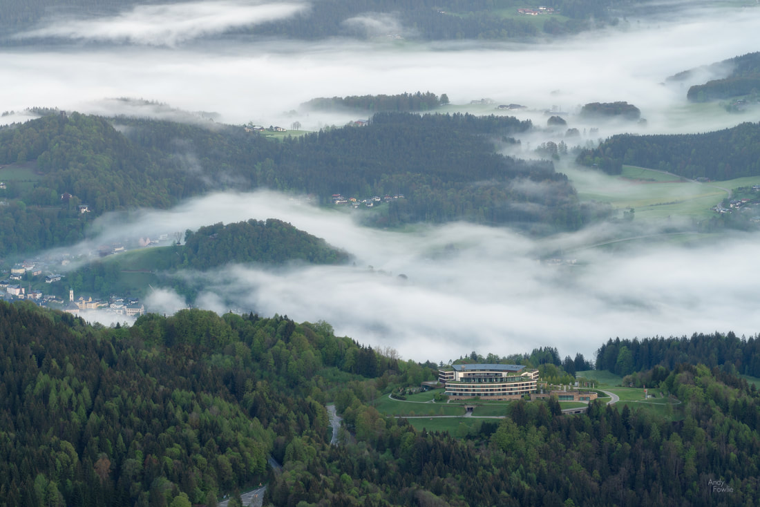
the magnificent Kempinski Hotel Berchtesgaden overlooks the valley, the centre of Berchtesgaden can be seen below on the left
Overlooking this area, perched on the mountain above Obersalzburg, you can catch a glimpse of the Kehlsteinhaus or "Eagles Nest", a nazi stronghold from the 1930s. The Kehstein mountain is a sub-peak of Hoher Göll.
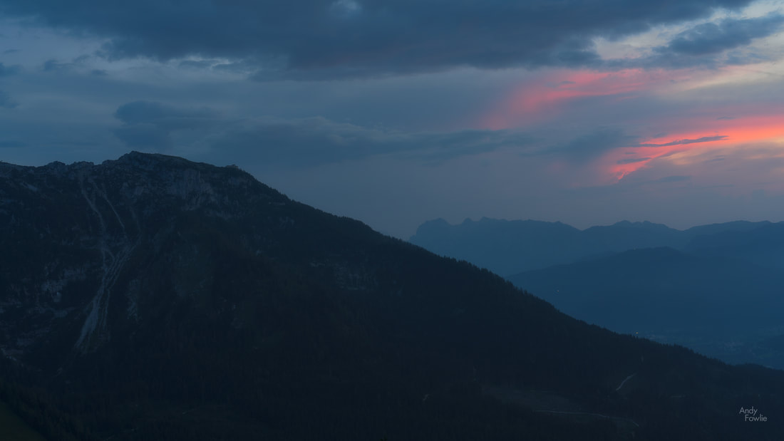
Kehlstein in the twilight
Hoher Göll itself is a popular climbing destination, offering a variety of different routes to to summit, from the pretty easy to the pretty challenging. The Purtschellerhaus, perched beautifully a few hundred vertical metres below the summit, provides a welcome staging post for climbers and a point of interest for any photographers who might point a lens in that direction from Rossfeld.
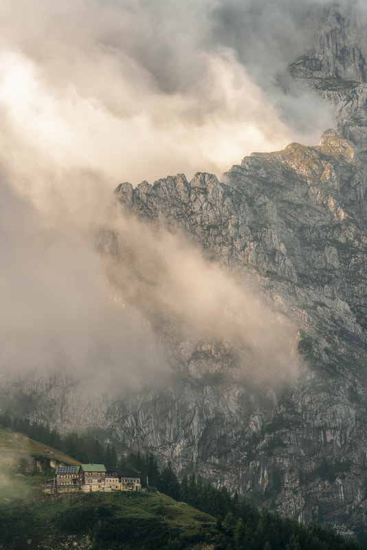
the clouds swirl above the Purtschellerhaus
The range of different heights in the surrounding mountains means that you often have some feature or another which is in the clouds at Rossfeld. This can be a great bonus for photography. I particularly liked how the clouds were gathering above the Purtschellerhaus on this September morning so I captured their motion in a time-lapse.
The jagged rocky slopes also give great opportunities for dramatic images when the clouds are performing for the camera.
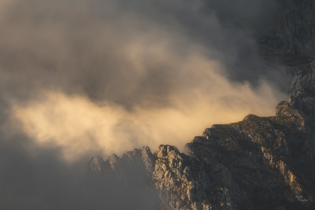
"the cauldron" - on the slopes of Hoher Göll
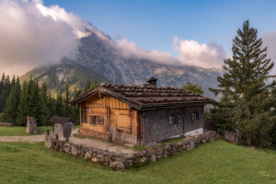
Now that we have covered the 360 degree attractions of Rossfeld it is only proper to mention the highlights of the mountain itself. The Ahornkaser is the highest tavern in Germany that you can reach by car and it offers a chance to get refreshments while on the mountain. It is also a good vantage point for photography with a charming mountain cottage nearby that has Hoher Göll as a great background.
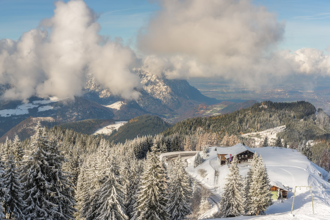
The views that you can enjoy from Rossfeld are available all year round thanks to a dedicated effort being made to keep the road clear. I have previously visited during times of heavy snowfall and still been able to drive without any difficulty to the summit. Indeed the slopes on the north of the mountain are an active skiing area with beautiful panoramic views.
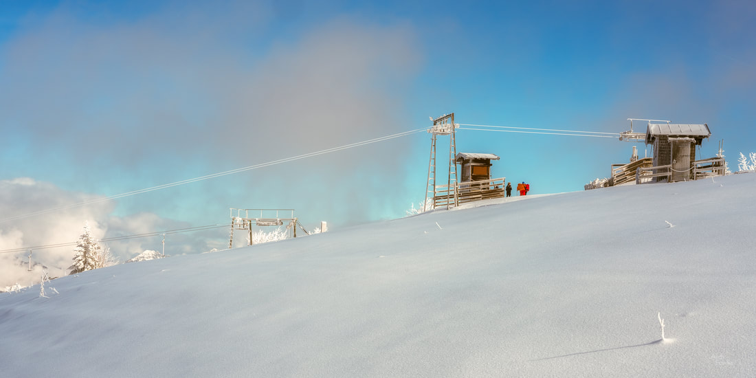
A beautiful winter day
I hope that this introduction has made you eager to visit Rossfeld, it is one of my favourite places to take photographs because there are so many compelling possibilities in one easy to reach destination. I look forward to returning to Rossfeld in the future!
Until next time, Andy You can also find me here
Recent Posts
2 Comments
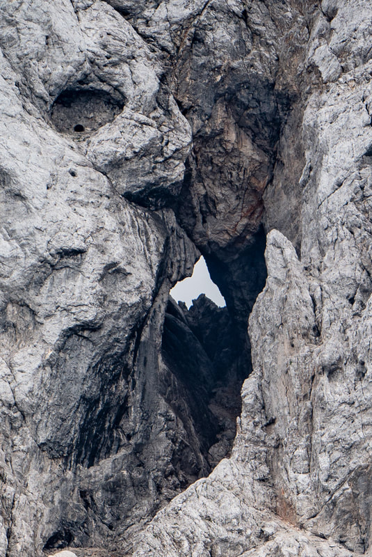
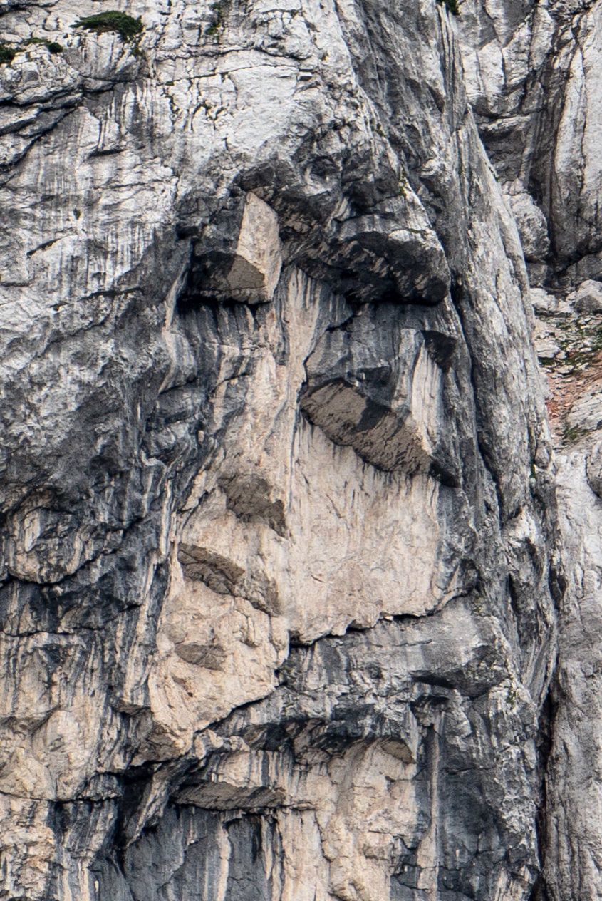
At 0345 my alarm sounded. I did not even have to open my eyes in order to judge the weather conditions, the wind was hurling raindrops with remarkable ferocity against my west facing window in the Fron Deg Guesthouse. A beautiful sunrise seemed monumentally unlikely. On days like this it can be overwhelmingly tempting to stay under the covers and start the day with a lazy breakfast instead of some foolish adventure. Six or seven minutes later i was on the road, heading towards a location near Barmouth. After a 30 minute drive, the final section of which took me up a rather narrow track, I started hiking through a forest in the darkness, following a trail which should deliver me to a viewpoint. The rain was intermittent, but did not cause much hardship while I was under the cover of the tree canopy. As the ambient light began to reveal more of my surroundings I got my first few glimpses of the Mawddach estuary through some gaps in the trees. As the trees gave way to heathery scrub at the top of the hill the full panorama revealed itself, but the weather conditions were ugly and boring. I took a few shots, without much enthusiasm and then got distracted by some interesting rocks and tried to find abstract patterns to photograph. At least I had got myself out of bed, and had a nice morning walk. I decided to head back for breakfast. I walked back down the hill a bit... then changed my mind and decided to use the time to practice shooting timelapses, something I have been meaning to get into. I set a timelapse going and then resumed my seach for patterns in the rock. A few minutes later I looked up and saw that the sun was starting to fight it's way through the clouds... a magnificent sight.  Elemental Battle My timelapse was still running, and indeed it had captured the progression of this elemental battle as raged above the estuary, driven on by the westerly wind. Timelapse photography involves shooting a large number of images of a scene and then using those images as frames in a video. The resulting footage has some noticeable differences to normal video content, the most striking of which is that it can be used to show changes over a significant length of time in a relatively short clip. The timelapse above is made from 900 images, captured once every 2 seconds over a period of 30 minutes, the resulting footage has a duration of 30 seconds. I have done some experiments with this kind of work over the past few trips and start to be more proficient with both the capturing and processing of timelapse footage. I think that there will be the occasional timelapse to be seen in my future posts. There is nothing much better than the feeling you get when sitting down to a good breakfast with the thought that the day has already been worthwhile. The morning routine following a sunrise excursion has a familiar pattern - cereal, sausage, bacon and eggs, toast, orange juice and coffee... probably more coffee... copy the morning's pictures to my laptop, charge batteries, shower, get dressed and head out exploring. My next destination was a bit of a drive away, I followed the road along the coast, around the Mawddach estuary and into the countryside to Dolgoch Falls. 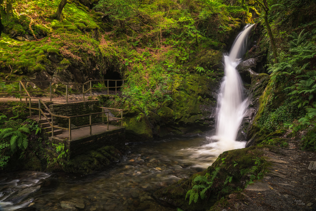 Dolgoch Falls This beautiful forest waterfall has an excellent cafe (the Dolgoch Tea Rooms) nearby and some possibilities for a bit longer walks nearby.  the balancing stick I sometimes get asked about how my images are processed, and that seems to be one of the major topics of debate in the photography community as well as in the looking at photography community. A few weeks ago I wrote down my own thoughts about such discussions in a short article that you can read here. As a follow up to that article, for those who prefer to see some concrete examples, I made another post showing a before and after comparison for two finalised images (including the one above). For the final couple of days of this most enjoyable trip I moved my base of operations to the town of Llandudno, where one of the attractions is a grand old pier. 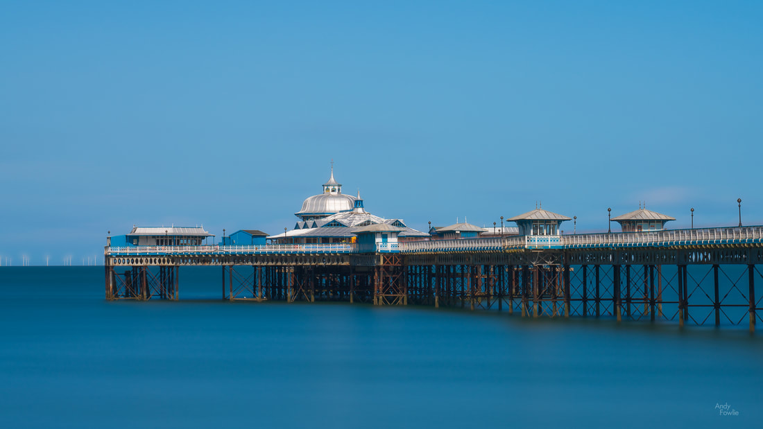 Llandudno Pier - a 200 second exposure calmed the waters of the sea Most of the places that I found interesting in this area were beside the sea. There are many beaches and coastal areas, each with different characters and features. The long, west-facing, rocky beach at Dinas Dinlle was a great place to watch the sunset and it also has a decent fish and chip shop right next to the car park... what more could anyone possibly want? 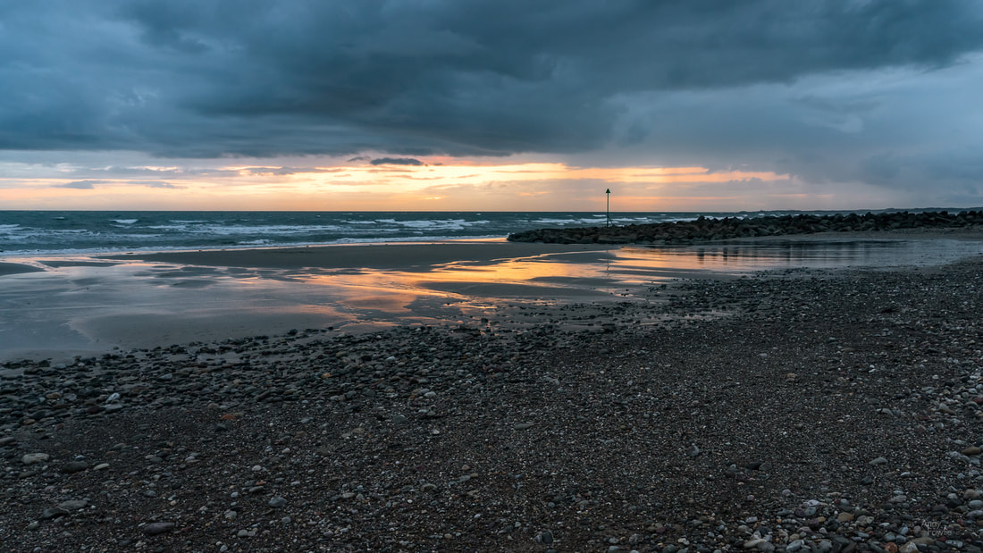 Dinas Dinlle - dusk descends Another feature of this area is remarkable castles, two particularly fine examples are preserved at Conwy and Caernarfon, both of which date from the 13th century. 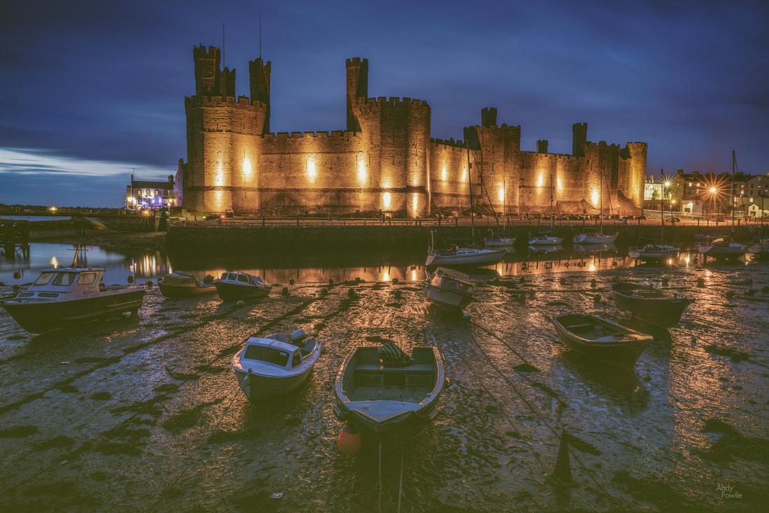 Caernarfon Castle, at night with low tide By this stage of my journey the constant late night-busy day-early morning routine was starting to have a cumulative effect. In autumn and spring it is quite possible to go on almost indefinitely shooting both sunrise and sunset every day, but in summer the period between those is just too short to get enough sleep. It was something of a relief to have the possibility to get to my sunrise destination the next morning with a 400m walk from my accomodation instead of a long journey. 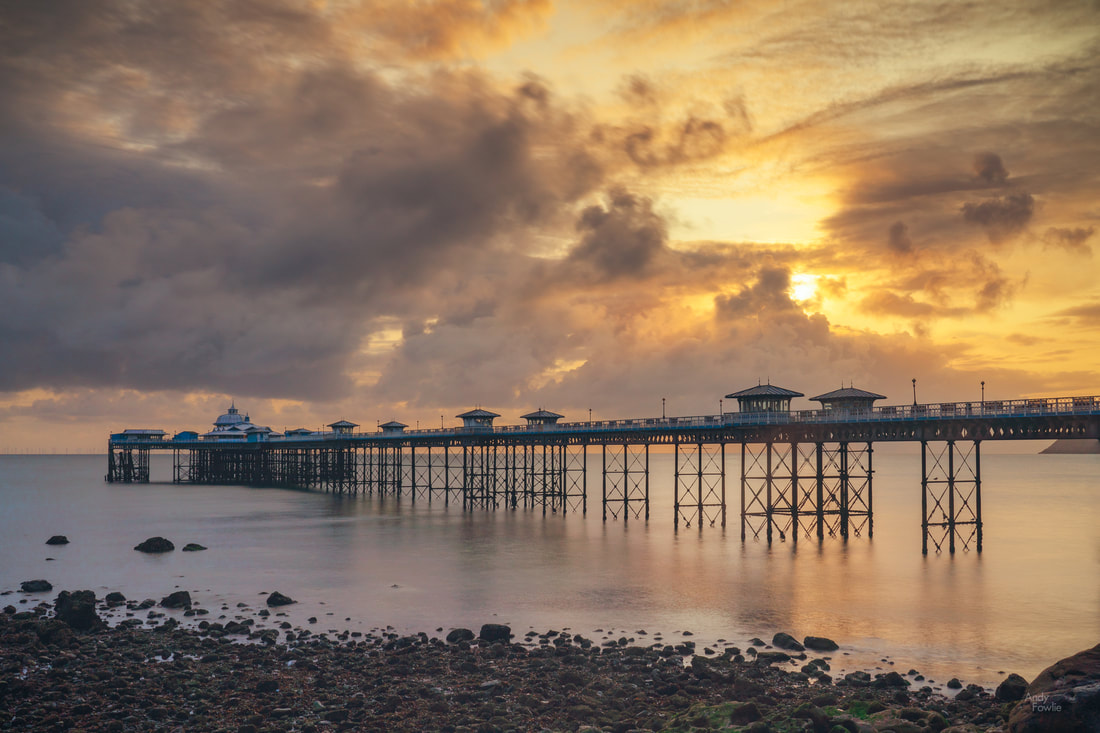 after sunrise at Llandudno Pier. On my final full day in Wales I decided to explore along the north coast, stopping first at Llandulas beach where there are some interesting coastal defences. Thousands of huge concrete blocks, shaped something like jacks (from the classic game, it's just a matter of time before modern youngsters leave their devices behind and return their efforts to games like this), are piled up along a 7 mile stretch of coast. The most obvious, and already much photographed, landmark to add to any picture of these sea defences is Raynes Jetty, a structure extending out to deep waters in order to allow cargo ships to be loaded with the products of the nearby Raynes Quarry. 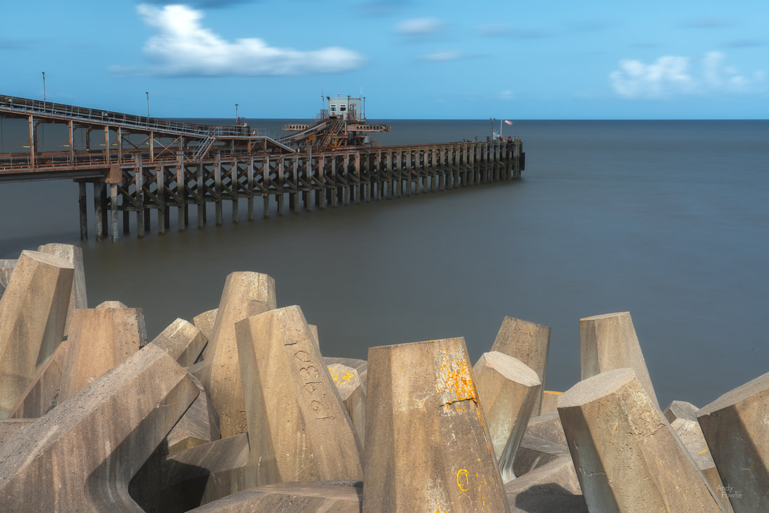 Raynes Jetty, viewed across the the sea defences At the most northern extreme of the Welsh mainland you can find the golden sands of Talacre beach and their crowning glory, the Point of Ayr lighthouse which sits out in the surf, about 50m offshore, at high tide but can be approached on foot across the sand at low tide. 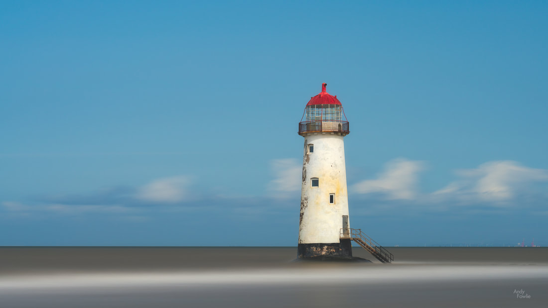 Point of Ayr Lighthouse - a two and a half minute exposure My first visit to North Wales was a most enjoyable one, and I am sure that i just scratched the surface of what it had to offer. I hope that I can return one day, maybe in some better conditions so that I can explore more widely in the mountains of Snowdonia. Thanks for your attention and support! Until next time, Andy On my first visit to the Lake District my favourite lake, by far, was Buttermere. This relatively small, but very beautiful, lake is surrounded on all sides by steep fells which lead up to some interestingly shaped peaks. The lake itself has a long and thin shape which means that when you look across the water the peaks on the far side look comparatively imposing and immediate rather than sloping gently upwards into the distance. On my last day in the Lake District I visited Buttermere for the fourth time, hoping that I could finally take some pictures.  looking south across Buttermere with the peaks of Haystacks visible through the mist The walk around Buttermere takes you past or through many working farms, mostly sheep farms, and it was very common to find sheep wondering around on the narrow roads leading through the village. Caution is needed when driving in this area and also if you are one of the many people who bring their dog to Buttermere for a walk, there are signs at multiple points on the Buttermere circuit telling of the danger dogs pose to newborn lambs and warning that farmers have the right to shoot any dog which is not on a lead and is bothering the sheep. 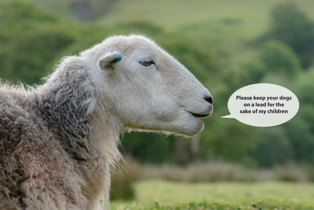 the leader of the sheep asked me to record a statement The weather was still a bit questionable considering it was early summer, but at least the wind had reduced to some extent allowing for some reflection shots and making it possible to do slightly longer exposures without the shots being ruined by movement in the trees. 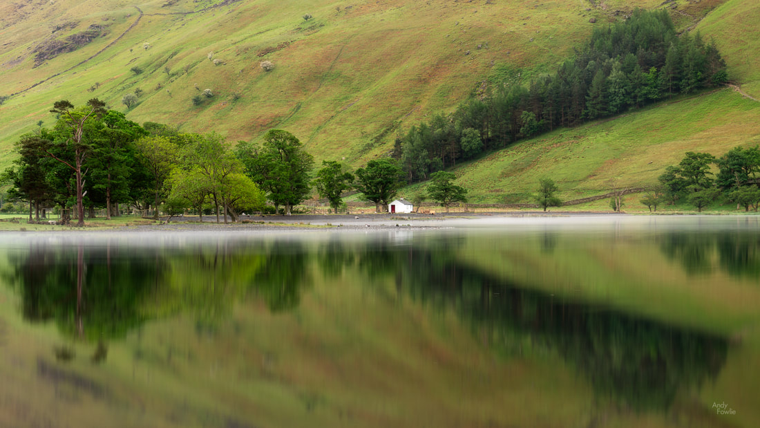 the trees and their reflection form a "pair of scissors" shape as some morning mist hovers over the water The road which runs along the north-west side of the lake takes you past the lovely little church of St. James. The present church building is 180 years old but there has been a church of one form or another on that spot for over 500 years.  "the lord is my shepherd" - a stray sheep poses nicely in front of the church of St. James As you make your way around the lake the path is often close to the shore but in the nesting season there are some detour put in place to keep traffic away from areas containing young birds. These diversions take you up to the same level as the road and offer some different views across the lake. On the far side of the lake (away from the road) then the path sometimes takes you up into the forest and there is also a couple of waterfalls in the area - all in all there is plenty to see and a good variety of views at Buttermere. 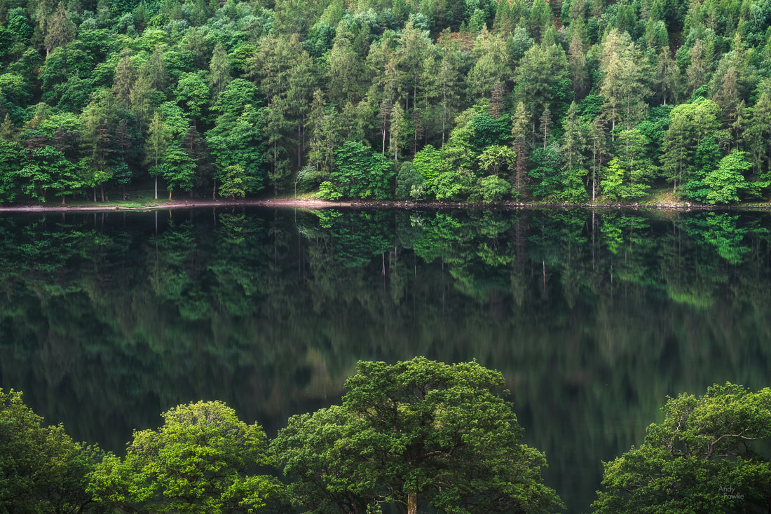 a green scene I am happy that I was finally able to get at least some shots by which i can remember Buttermere, even though it took 4 visits and still the conditions were far from ideal, hopefully one day I will get the chance to be there again with a bit better luck. 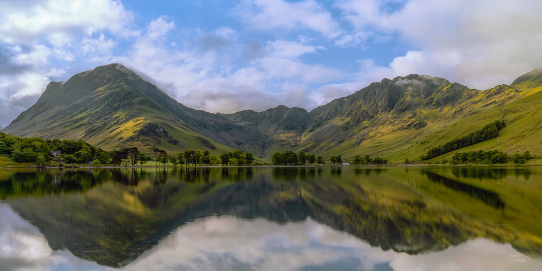 bye bye Buttermere I left Buttermere behind for the final time and headed for one final Lake District destination, the Rydal Waterfalls in the extensive grounds behind Rydal Hall. The hall is a grand old building, the former country home of the Le Fleming baronets. The gardens are very attractive and well taken care of and feature the lowest of the series of waterfalls as a highlight. 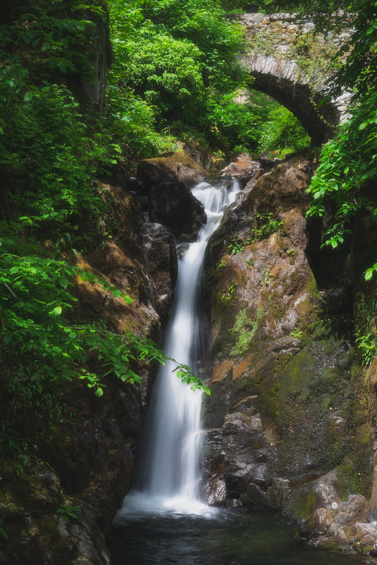 the lowest of the Rydal Waterfalls One unusual feature of this waterfall is that there is a small building known as "the Grot" which was erected for the sole purpose of comfortably viewing the waterfall.  the view from "the Grot" As you follow the course of the stream up the hill from this lower waterfall you come to some minor rapids.  Rydal rapids Above the rapids there is a nice looking weir with various choices of foreground interest...  the weir at Rydal Hall. ... and finally at the top of the estate there is one last waterfall.  the final waterfall After my Lake District trip ended I had arranged to meet my parents in the seaside town of Grange-over-Sands, a place which I had heard mentioned many times but never visited before. When my father was a small boy it had been a tradition for his family to spend a few days in Grange as their summer holiday so it seemed like a suitable place to meet up and reflect on old times. We spent a very nice couple of days there before they returned home to Scotland and I continued my photography trip by spending some time in Northumberland on the east coast of England. There was not much focus on photography in Grange over Sands, but I did manage to photograph my 204th different bird species, a Muskovy duck at the duck pond. 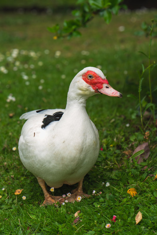 a Muskovy Duck I very much enjoyed my first visit to the Lake District, despite the weather and the rather expensive "paying and displaying". I look forward to visiting the area again! until next time, Andy For the last two years I have been travelling and shooting at a bit of a frantic pace, always impatient to move on to the next trip. During this summer I have been at home for a period of a few weeks and that has given me an opportunity to evaluate my recent efforts in a bit more depth and examine the progress that I have made while considering how I want to further develop as a photographer. I took the opportunity to combine this period of reflection with an exercise to update my portfolio (a collection of images that I publish on this site in order to represent my work), adding some newer images that I felt merited inclusion, updating some existing images to reflect my current preferences and retiring some which no longer please me. The updated portfolio can be viewed by clicking on the picture below, or by selecting "portfolio" from the site navigation. 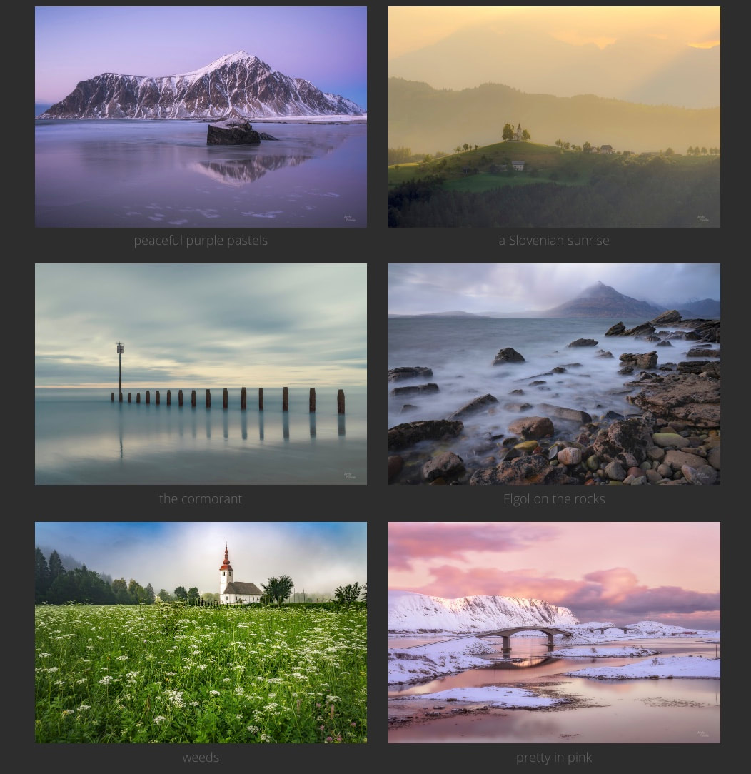 In another new development I have partnered with Fine Art America in order to offer prints of each of my portfolio images in a variety of sizes and materials, with or without frames, as well as greetings cards featuring each image. All printing, shipping and delivery is handled by Fine Art America who have a global network of locations each of which can fulfil orders. Having ordered some samples to test the quality and speed of their service I can report that I am happy with what they provided. My order from Finland was processed by their delivery centre in the UK and arrived in less than a week. Fine Art America offers a no questions asked refund policy within 30 days of ordering which provides some additional peace of mind. For anyone who is interested in buying a print there is a "buy print" button in the larger view of each portfolio image, and there is also a possibility to see all the offered images by selecting "Store" from the site navigation or clicking the image below.  I hope that you enjoy looking at my new portfolio images, and I am looking forward to getting back into the field to capture future portfolio candidates. Please don't hesitate to contact me if you have any questions about prints from my store or if you would be interested in prints of any of my images which are not currently listed in the store. Thanks for your attention, the next blog post will be back to my normal field reports. All the best, Andy P.S. special thanks to all those people who gave feedback to me as I was considering the updates to my portfolio, your input was most useful. Despite having grown up in Scotland, I had never really spent any time in the west of the country. On my recent trip to my home country I tried to make up for lost time, visiting some of the beautiful places in the area between Stirling and the Skye bridge. Waterfalls, mountains, castles, wildlife... this part of Scotland has a huge amount to offer. My first stop was at the Loup of Fintry, a series of waterfalls on the River Endrick, set in some lovely rolling countryside.  the Loup of Fintry Waterfalls were a strong feature of my Scotland trip and are always interesting photographic subjects, any scene with a combination of moving and stationary elements provides additional possibilities as you can decide whether to freeze the motion with a short shutter speed or blur the motion with a longer exposure. As ever at these popular (and heavily photographed) destinations it is my hope to find a more original composition, often the best chance for that lies with a more intimate scene.  a lone tree is highlighted by the sun at the other side of the falls I continued my journey, staying the night near to Aberfoyle. This area would have been full of interest for me under normal conditions but the weather was at it's most uncooperative and any more expansive views were obscured. I decided to change my activities to fit the conditions and spent my time hunting for moody scenes on the edge of a forest.  "Fangorn" I have found that having a solid plan for what to photograph can be a great benefit, but only when accompanied by a willingness to totally disregard that plan when prompted to by the conditions or the light. It is easy to spend a great deal of time and effort chasing something that isn't really possible just because you get too set on a pre-conceived idea.  apart Leaving Aberfoyle behind, but bringing the dismal weather with me, I decided to head towards Glencoe for a few days. On the way I sought out some waterfalls - overcast and miserable weather is highly suitable for waterfall photography. My favourite of these was the Falls of Falloch.  the Falls of Falloch My base in the Glencoe area was the nicely situated Isles of Glencoe hotel in Ballachulish, on the shore of Loch Leven. This location was perfect for exploring the surrounding territory and also offered some photographic opportunities without needing to get into my rental car. 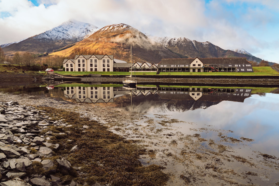 the Isles of Glencoe hotel During this section of my trip the days took on a certain similar rhythm as the weather was variable at best and miserable at worst. Go out, explore, get wet, try to get things dry, sleep, repeat. I tried to take advantage of the occasional moments where there was a break in the gloom and otherwise alter my ideas such that I was embracing the conditions rather than fighting against them. When I visited the shore of Loch Laich the conditions were exceptionally miserable, but perhaps this was appropriate when visiting the Castle of Aarrgh from Monty Python and the Holy Grail (also known as Castle Stalker in real life). 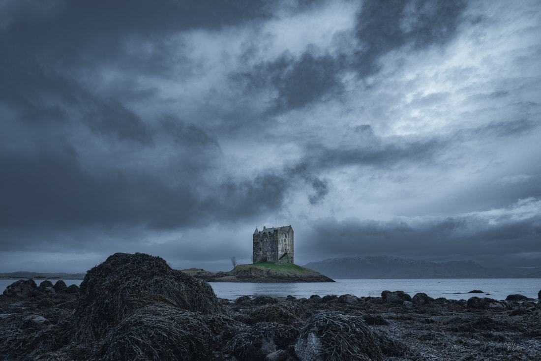 the Castle of Aarrgh The gloomy conditions were still prevalent by the time I made my way to Kilchurn Castle, a ruined 15th century structure on the banks of Loch Awe. 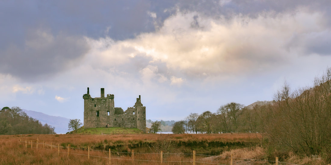 When the water level is low it is possible to see this castle from up close but I found that the most attractive views were to be found from the other side of the Loch. As I was exploring these possibilities I noticed that the sun had found a small window in the fast moving clouds and a golden beam of light was making it's way along the hillside in the background. I was hoping that the light would fleetingly illuminate the castle itself but I had to make do with it painting the hills behind in gold. 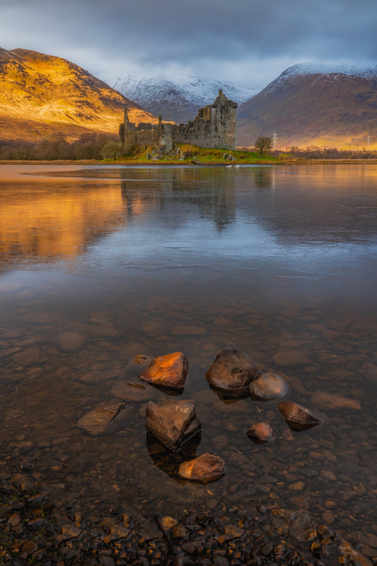 Kilchurn Castle across a partly frozen Loch Awe The lovely Glen Etive can be found just up the road from Glencoe. There is a very popular photography spot near Glen Etive where a small waterfall provides the foreground with the iconic triangular peak of Buachaille Etive Mor dominating the horizon. This was one of those spots where, for me at least, the experience of visiting this spot was more depressing than inspiring - the procession of photographers and tourists all heading to the same spot had created a huge mud bath where the path used to be and the activity was clearly detrimental to the area. I still captured some images there, but without the good feeling that I often get from new places. 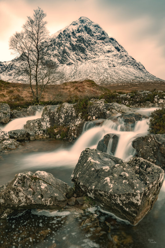 Buachaille Etive Mor Over the past months I have been somewhat in conflict about my activities. I very much enjoy visiting new places, being out in nature, and trying to capture my own interpretations of the places that I find inspiring. I try to conduct myself sympathetically towards the places I visit and not leave any detrimental traces behind. On the other hand I hate to see beautiful locations getting spoiled by careless human activity and on occasion there are places like this where the sheer scale of traffic is very damaging even if all the visitors behave responsibly, just the act of going to such a place has a negative impact. Photographers are not the only animals that can be found roaming in Glen Etive, a number of beautiful native red deer can be seen, if you are lucky, wandering around on the hillsides.  red deer on a Glen Etive hillside As I continued up the glen, on a single-track road with passing places (of course), yet more storm clouds and the setting sun were locked in an apocalyptic struggle.  Apocalyptic Glen Etive Back in Ballachulish it was finally possible to get some reasonable morning weather as the early cloud gradually gave way to a brighter and more promising day.  towards the Ballachulish bridge The mixture of clouds and sun can provide some of the most attractive conditions, I wish there had been a bit more of this kind of weather during my trip - but Scotland in any season is always likely to mean you will have at least some unfavourable conditions to deal with.  misty hills above Ballachulish The terrain of Scotland has fostered quite a tradition of climbing. There are no particularly high peaks (Ben Nevis is the highest at 1345m / 4413ft) but there are 282 separate summits of 3000ft or higher. These 3000ft peaks are known as Munros, after Sir Hugh Munro who produced the first list of 3000ft peaks in 1891. The Ladies Scottish Climbing Club was formed in 1908 by a group of lady climbers whose gender prevented them from joining the Scottish Mountaineering Club.  Blackrock cottage - one of the huts owned by the Ladies Scottish Climbing Club. Although Ben Nevis is the highest peak in Scotland, it is not the most spectacular looking when viewed from Fort William (the nearest major town) as the peak appears to be part of a wide and gently sloping dome rather than making a vertical reach for the sky such as you might see in more spectacular ranges. The mountain provides a stern challenge for climbers despite the benign appearance from a distance, each year it requires a few dozen rescues to be performed and claims a handful of lives.  an abandoned trawler at Corpach, with the summit of Ben Nevis shrouded in cloud As I made my way from Fort William back towards the Isle of Skye I passed through some beautiful scenery.  Glen Garry, bathed in sunshine A heavy snowfall coated the landscape in a white blanket and gave a very pure look to the scenery, conditions for driving were quite manageable on the main roads but it would have been easy for an unwary motorist to get stuck when entering lay-by's or side roads.  Loch Cluanie, as the snow falls As I drove through the beautiful Glen Shiel all trace of colour left the sky as the white clouds dominated, the fresh covering of snow made for a completely monochrome scene.  Glen Shiel, in living colour I spent the night in the cosy Kintail View bed and breakfast in Ratagan, a small village on the shores of Loch Duich. My thought was to photograph the mountains opposite (the "Five Sisters of Kintail") the next morning, reflected in the loch... but as is so often the case the shot that I was planning for just wasn't on the cards. The wind was rippling the surface of the loch and ruining the reflections while a heavy snowstorm was blotting out the rising sun. After enjoying a cooked breakfast (featuring a duck egg instead of a hen's egg) I walked up the rather steep old military road towards Glenelg, hoping to find a good vantage point. At this point the snow became increasingly heavy and visibility was reduced to a minimum, providing a different kind of opportunity.  a snowy forest abstract above Ratagan As I made my way back down to the village the sun started to fight it's way through the snowstorm which made for some very beautiful light, allowing me to capture one of my favourite images from this trip.  A painterly view across Loch Duich through the snowstorm towards (three of) the Five Sisters of Kintail. That's it for this time, thanks to all who have read this far and to any who like or share this post on social media, I appreciate the support. Until next time, Andy Earlier this year, as part of an extended visit to Scotland, I finally made my first visit to the Isle of Skye, one of the most spectacular parts of my home country. My travel schedule, on the road for 48 nights in a 70 day period, left me with quite a backlog of images to process and as a result it has been an unusually long time since I last posted in this blog. My Scotland trip lasted for 28 nights and my initial plan was to start with a few days in Skye before travelling around the coast, stopping occasionally to check in with parents, brothers, sisters-in-law, nephews and nieces along the way. The first part of my journey, driving from Edinburgh to Skye, was somewhat complicated by some food poisoning or other temporary debilitation which left me feeling like I had a truly horrendous hangover - this seemed rather unfair considering I had not touched a single drop of the various enchanting liquids that Scotland has to offer. I passed through glorious scenery in wintery conditions without having any energy available to stop and take photographs. Thankfully the ill-effects only lasted for 24 hours and I was free to explore the scenery after a good night's rest.  the Blackhill waterfall is one of the sights visible from the main road through Skye For the first couple of nights I stayed at the Skeabost Hotel which turned out to be an excellent choice, a stylish and comfortable place to stay with a traditional feel to it and beautiful surroundings. My only complaint about the hotel is that breakfast included such perfectly poached eggs that it was very tempting to prioritise eating breakfast over photographing sunrise... photographers beware when staying here! On this first day i visited the area near Sligachan, a small settlement roughly in the centre of the island, where the local highlights include the Sligachan river, an old bridge and great views towards the Black Cuillin mountains. This was one of the more beautiful days of the whole trip, sunrise itself was a muted affair as there was thick cloud or mist but as the morning progressed I witnessed a beautiful battle between the rising sun and the dwindling clouds. 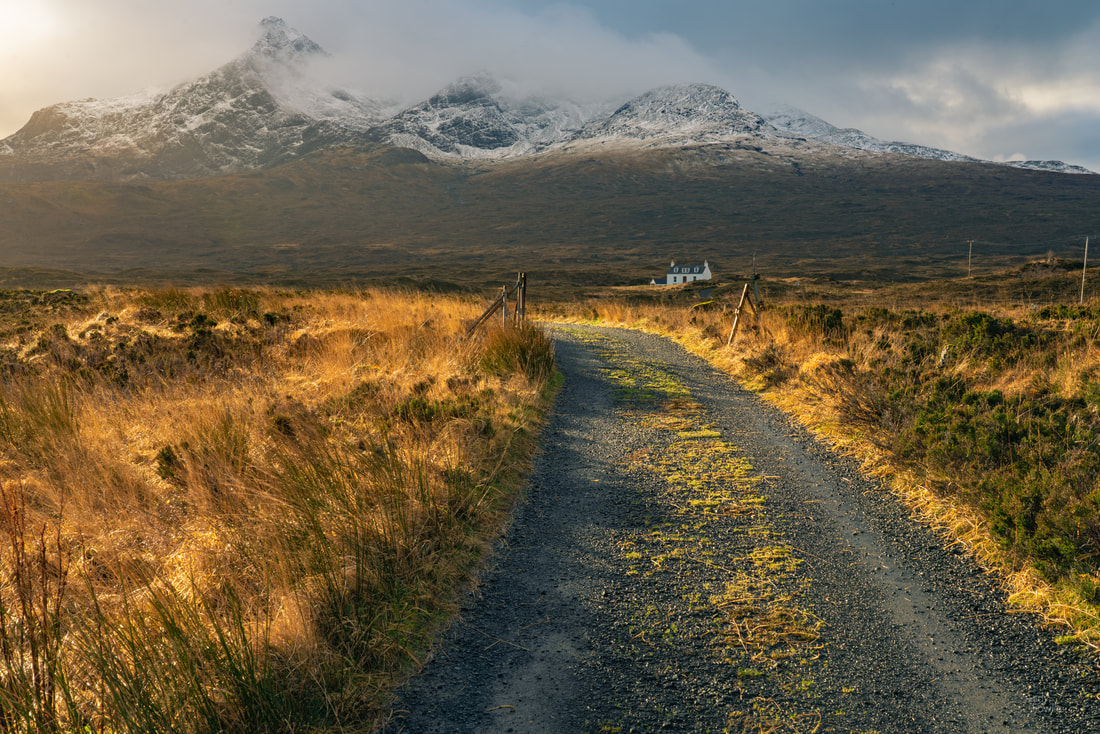 At the foot of the mountain - a lonely cottage at the foot of the Black Cuillins. Gradually the sun started to get the upper hand as the morning progressed, I have often found that the times when there is no decisive advantage for the clouds or the sun offer much better photography conditions than those times where it is just sunny or just cloudy. 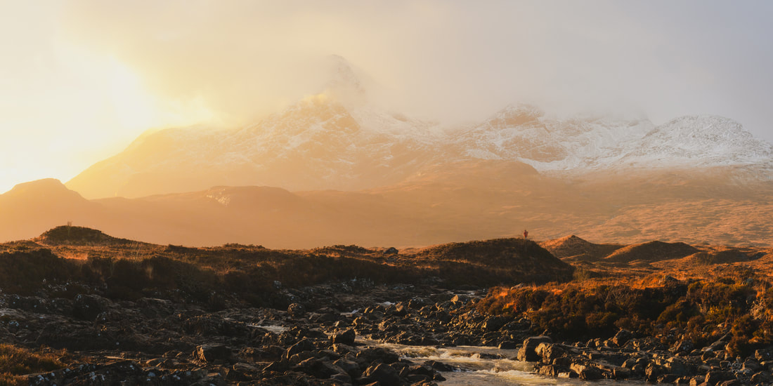 the observer - a red-jacketed photographer watches the sun break through the clouds behind the peaks of the Black Cuillin as the Sligachan river burbles along in the foreground Eventually the sun became the clear winner of this battle and there followed a period of very pleasant, but less photogenic, blue sky. 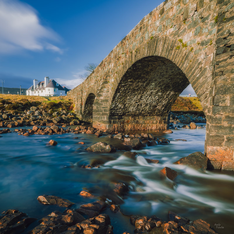 Under the Bridge - the river flows under the old bridge at Sligachan Moving west from Sligachan, I took a turning near to the Talisker whisky distillery and travelled along a long single track road to a remote rocky beach. The 60m high waterfall draining into the sea was one attraction but I was also somewhat fascinated by a more grizzly sight. A sheep had met it's end on the rocks of the beach (perhaps trapped in the rocks and claimed by the tide?) and this sad event had left the sheep as a woolly skeleton on the beach. Apologies to anyone who finds the picture disturbing. 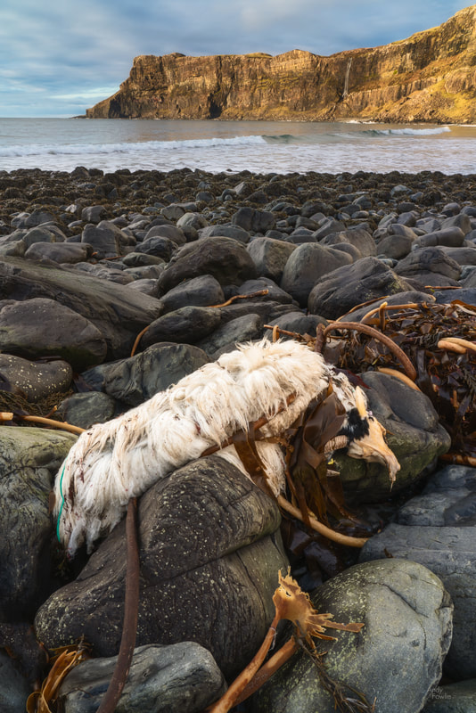 Sheepwreck The single track roads (i.e. two way roads only wide enough for one car) with occasional passing places are a feature of a lot of the less densely populated parts of Scotland, and Skye is no exception. To start with it can be a bit of an uncomfortable experience to encounter oncoming vehicles in the middle of the road, and I guess that nobody is that excited to have the opportunity for a long reverse, but you soon get used to it, even in an unfamiliar rental car. During my Scotland trip I estimate that I drove about 1000 kilometres on single track roads in the Skoda Superb (perhaps a bit overconfident naming... but I guess they would not sell the "Skoda Perfectly Decent" in such high numbers) that I rented from Sixt. The journey to the spectacular lighthouse at Neist Point includes a long stretch of single track driving, with the added hazard of many hundreds of sheep wandering around. Usually sheep will get out of the way of a car eventually, but not until after you have slowed down to a crawl and gradually approached to within a few metres. All of this adds to the genuine local experience, and the journey is worth it.  Sunset from the cliffs above Neist Point This lighthouse, in it's iconic location, has to be one of the world's more memorable places to visit and it was great to be able to be there during the sunset and the early evening.  Neist Point after dark The following day's weather proved to be rather variable. Those readers who are familiar with Scotland will know that variable is about as good as you can hope for, especially in late January, and from a photography point of view variable works very well as the transitions between different conditions often provide the most interesting light. I decided to explore a bit further south in Skye and took a turning onto (of course) another single track road after following the main road to Broadford. This took me to the picturesque Loch Cill Chriosd during the most pleasant period of weather.  the still waters of Loch Cill Chriosd with Beinn na Caillich in the background This was another beautiful area and I walked here for some time along the banks of the Loch and in the adjacent hills.  waiting for spring I continued along this road, heading for another remote beach and hoping for some interesting sunset light. Along the way I passed through some beautiful scenery and had further experience of avoiding the sheep that wanted to share the road with me, but after some time I came across a different kind of obstacle - a small herd of Highland Cattle was staring at me with the afternoon sun at their backs. 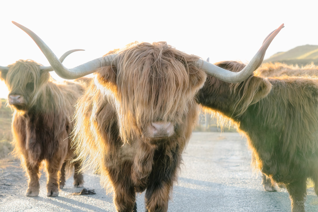 heavy traffic These beautiful animals were a bit of a different proposition to the sheep which it had been more usual to encounter on the roads. A quick experiment showed that inching slowly towards them did not result in them retreating... just an increase in my anxiety about the possibility of having to explain numerous horn holes to the car rental company at the end of the trip. They had a very small calf in their number and it may have been that concern about protecting the little one was behind their reluctance to move. I pulled into a side road and decided to photograph these amazing animals instead of arguing further with them about rights of way. This situation was resolved after some time as the herd gradually drifted across to one side of the road and allowed vehicles to carefully creep past, so I continued on my journey to the village and the beach at the end of the road... by which time the weather was taking a turn for the worse.  primordial - a long exposure on the beach in a gathering storm Once again I was able to witness a battle between the sun and the storm, but on this occasion the sun would definitely be on the losing side, managing only occasionally to burst through the storm clouds for a few moments before the darkness and rain took over for the night.  the last embers I think I will end this post on that note, there will be a bit more to come from Skye and from my Scotland trip in general in my next posts over the coming weeks. Thank you to all who have read this post, I hope that you have enjoyed it. As ever it is most welcome if you share my posts on social media. Until next time, Andy So.... where were we... ah yes, I signed off last time on my way from the Grmecica waterfall back to my car in Nomenj. I always enjoy it when i feel like the first shooting destination of the day has been a success. On a trip like this I usually end up with a handful of pictures that I am satisfied with and if I am lucky then maybe one that I really like... so when I feel like the day has started well then it means that anything good from the rest of the day feels like a bonus. Of course the opposite is also true... an uninspiring beginning increases the pressure on the rest of the day. Just a little something for any psychologists out there. I decided to head for the mountains to continue my day. I drove to Lake Jasna in Kranjska Gora. Lake Jasna is actually made up of two artificial interconnected lakes and is usually a lovely place to catch your breath before continuing into the mountains. On this occasion however dark clouds were gathering overhead and rain was starting to fall.  a dirty afternoon at Lake Jasna It did not seem very promising weather for landscapes so I turned my attention to wildlife where the well diffused light was an advantage and the dark skies were not a disadvantage. The first bird I spotted was a black redstart... a really beautiful bird and a relatively difficult one to find in Finland, but I have been lucky enough to see one in Germany, Austria and now Slovenia as well as Finland this year. 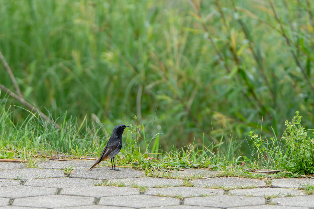 a black redstart surveys the lush greenery As you proceed from Lake Jasna the road takes you up into the mountains through the Vršič Pass, a wonderful road which connects Kranjska Gora to Trenta via the 1611m high mountain pass. This is quite an experience to drive with 24 hairpin bends on the way up and 26 hairpins on the descent towards Trenta. The present day road was built on the route of an earlier track during the first world war by approximately 10,000 Russian prisoners of war, their work and their losses (in a major avalanche which swept aside the avalanche fences) are commemorated by the wooden Russian Chapel which stands about half way up the mountain on the Kranjska Gora side.  the Russian Chapel As you approach the highest point of the pass you can find the starting points of a number of hiking or climbing routes and marvel at spectacular views of the nearby mountain peaks. The huge face of the Prisank mountain provides two points of interest which can be clearly seen from one of the roadside parking areas - the Prisank Window and the Pagan Girl. The Prisank Window is a 80m high, 40m wide hole which goes right through the mountain, one of the largest and best known mountain windows in the Julian Alps. The Pagan Girl is a pretty good attempt at a human face looking back at you from the rock wall, formed by erosion and rock falls, I remember reading at the site that the face was 120m high, but I cannot find confirmation of that from any other source so it may not be correct. 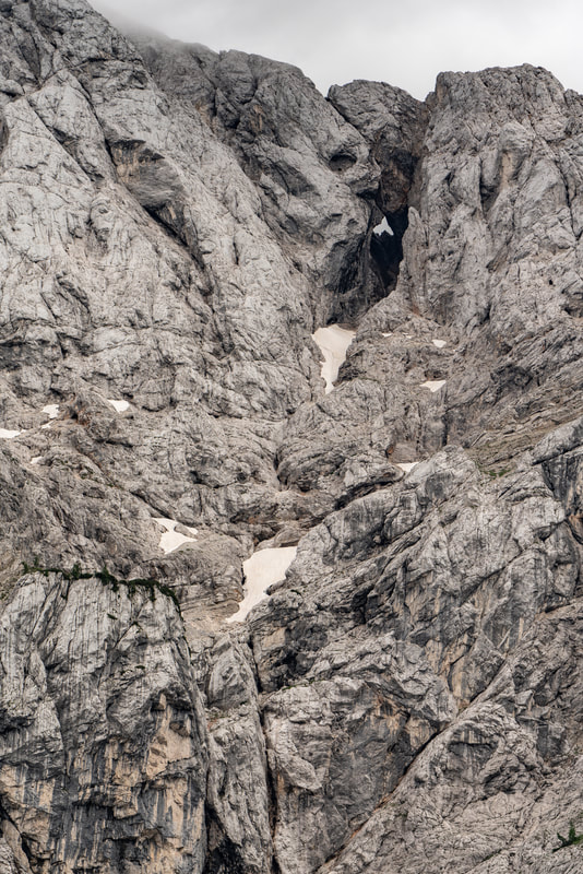 the Prisank Window (upper right) and the Pagan Girl (lower left)
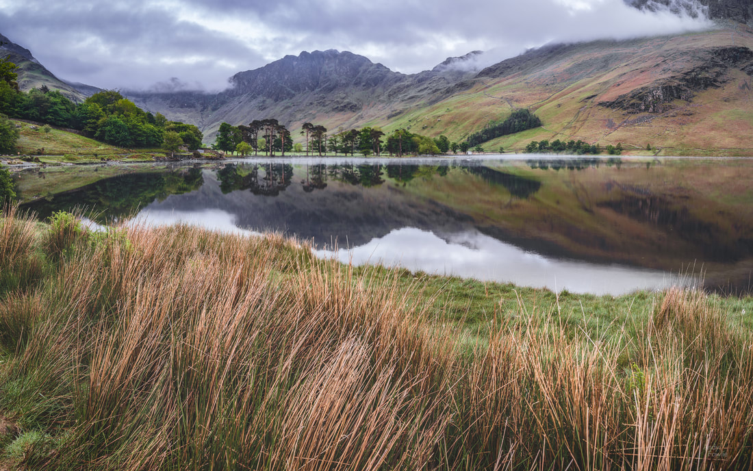
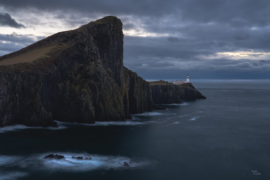
In order to appreciate the sheer scale of these cliffs I think that the following picture which I took in 2017 might help - the three tiny ants you can see on the top of the ridge are mountaineers. 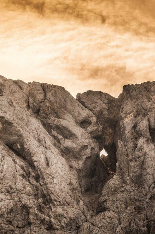 three chaps out for a stroll (2017) At the highest point of the pass there are a number of restaurants, a good amount of parking space and the possibility to follow many hiking trails. On this occasion I just looked at the view and headed back to base.  a mountain panorama The following afternoon England were playing Sweden in the World Cup quarter final and I wanted to watch the match... but I also wanted to take pictures... so I decided upon an early start and an ambitious road trip. I left the hotel at 0400 and was in position at Lake Jasna shortly after 0500. The water level was remarkably higher than the previous day and the sunrise was a total non-event... I moved on shortly after 0600. 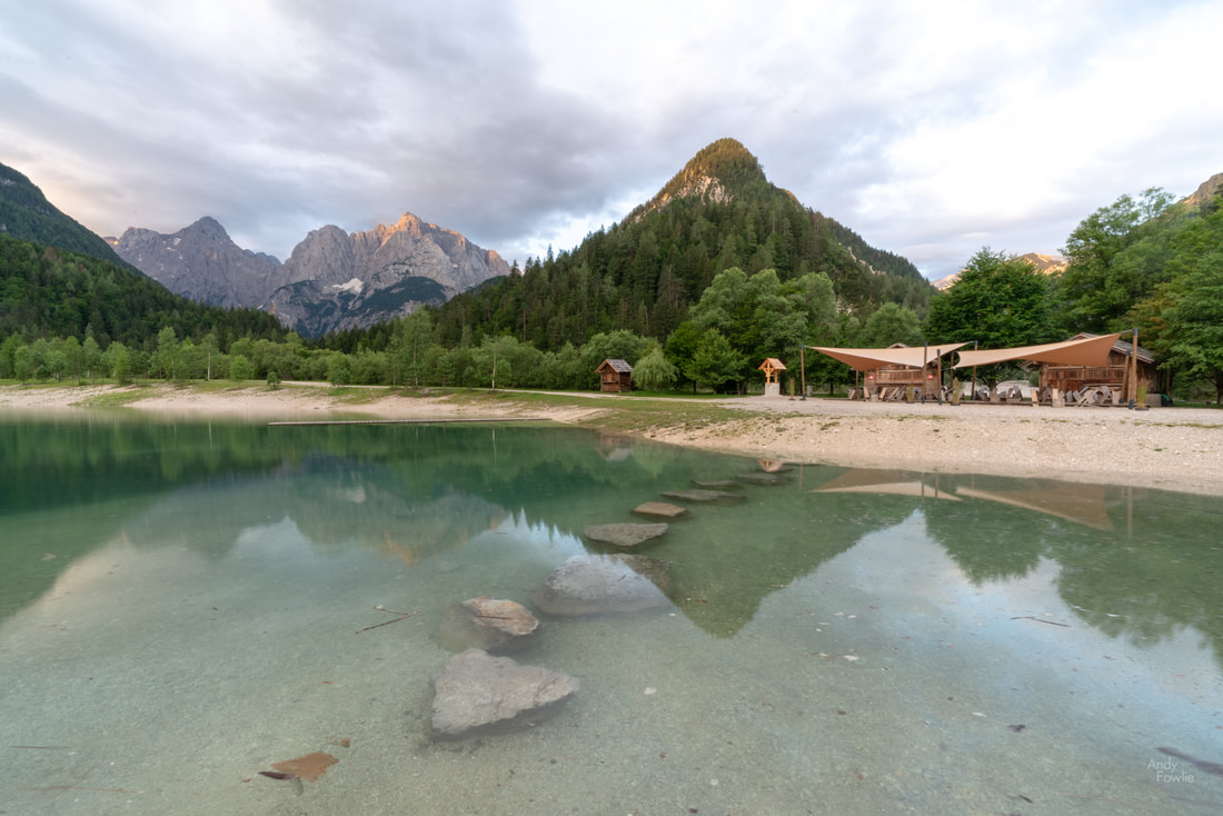 first stop - Lake Jasna By 0700 I had negotiated the 24 ascending and 26 descending hairpins of the Vršič Pass and was following the path of the very beautiful Soca river through the valleys. 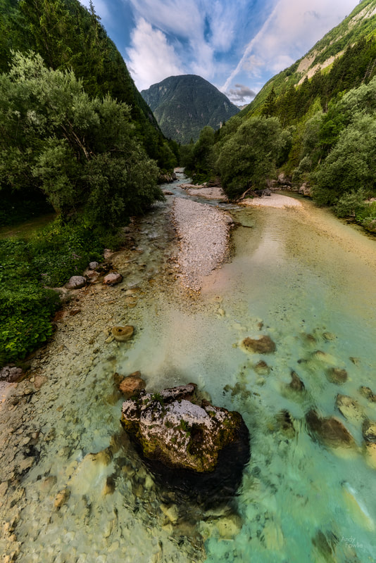 the emerald water of the Soca river I stopped to stretch my legs at the Great Soca River Gorge before 0800, this is a section of river which has carved out a steep sided canyon for itself, it is a beautiful and dangerous place with an unguarded drop to the raging water and rocks below. The section of river downstream from the gorge is a bit more open and gentle and a popular spot for sun worshippers and people in need of the refreshing experience of leaping into pools of cool water from the less high and less dangerous rocky banks. Although I enjoyed being there I did not find good ideas for photographs. By 0900 I was having a latte in the hotel near to the Boka waterfall. After a steep uphilll climb it was possible to observe this mighty waterfall, with an initial vertical drop of 106m and a secondary drop of 30m before feeding into Boka creek. The creek is one of the shortest in Slovenia, joining the Soca river after only a few hundred metres. The waterfall has the highest flow of any in Slovenia, reaching upwards of 100 cubic metres per second in the wettest season. On this occasion the flow was significantly less. 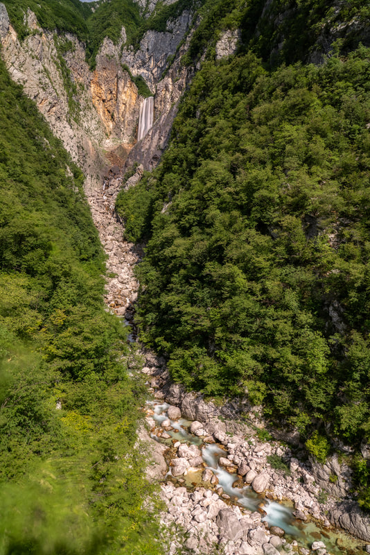 It's not small, its far away - the Boka Waterfall pours out from an enormous rock face and drains into the creek below. The scale of the waterfall is difficult to communicate in a photograph due to the scale of the surroundings... a 106m waterfall does not look so impressive when it is set in a 400m high rock face. You need such a wide angle lens to communicate the whole scene that the waterfall itself is reduced to a miniature size in the frame. 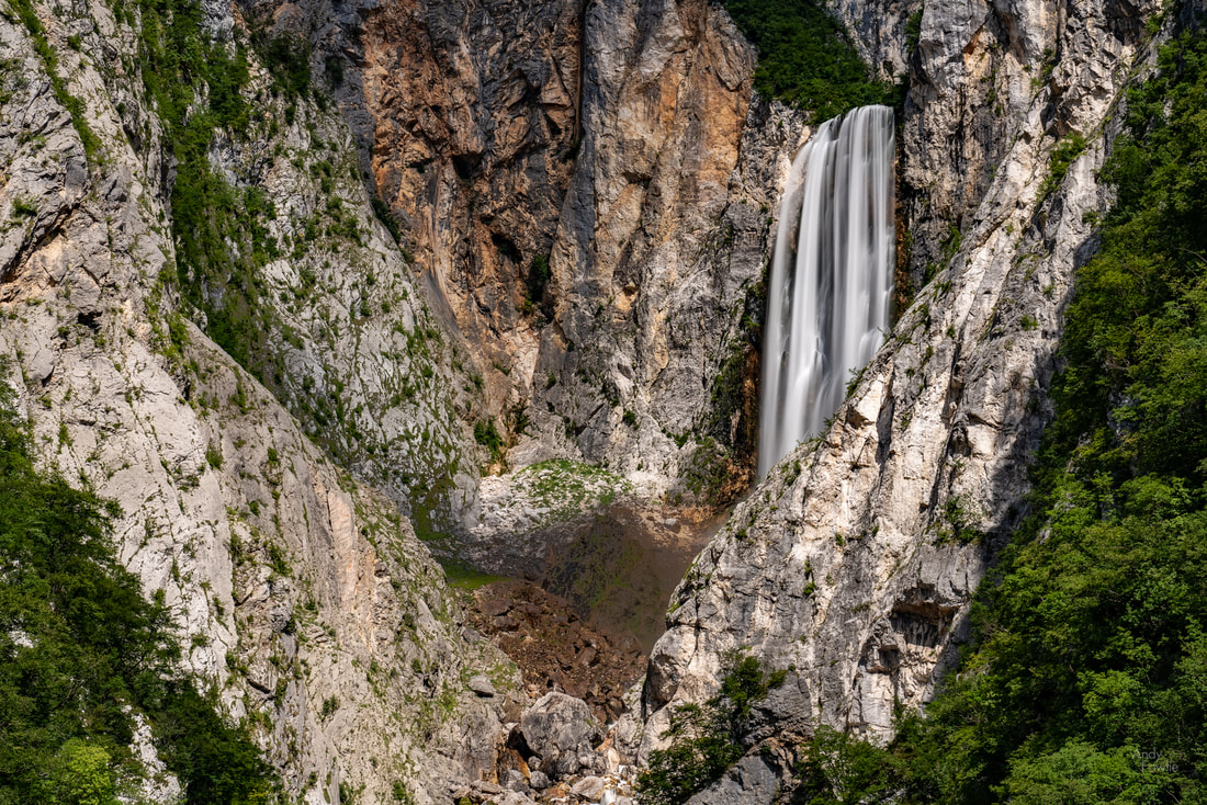 the Boka waterfall I had understood that there was an even higher viewpoint from where the view could be further improved but after ascending for another 15 minutes or so I began to feel that the downward journey would be a bit too hazardous if I continued upwards, there was quite a lot of loose rock and stones underfoot and it was a bit slippery. With no other people around I thought that the possibilities of having an unnoticed accident were higher than I would like. Anyway, this was a great place to visit and I recommend it for anyone who is in the area. It was possible to see the high water mark from the rocks at the base of the waterfall, I believe that it would be absolutely spectacular when viewed in peak flow. Onwards... my next stop was supposed to be Kozjak waterfall... but a difficulty with navigation brought me instead to a lovely hillside in the middle of nowhere... after ascending a large hill by a series of hairpins on a road which was not very wide. 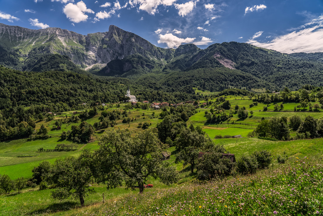 the church at Dreznica Here, on this beautiful hillside, battalions of insects were going about their most important business - pollinating left, right and centre. 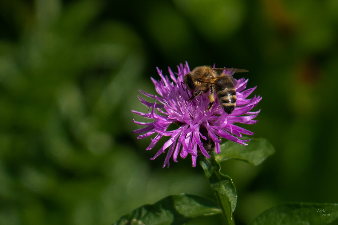 bzzzz I once again negotiated the hairpins on the way down the hill and found the spot I was aiming for in the first place, eventually managing to park in a "not big enough for all the cars" car park - a task which was complicated by some "its too hot and I already had enough of this and the kids are getting on my nerves" driving from some other visitors. Onwards... to Kozjak waterfall. The waterfall is easy to find by following the signs, and the crowds, as the path winds its way up the hill and along a wide canyon. The final 40m or so is on a narrow, wet, raised wooden ledge on one of the canyon walls into a cave like area where the waterfall is situated. This area requires attention and care - the wooden boards are generously sized for proceeding in single file but they have to carry two way traffic and passing is already a bit hazardous. The drop to the rocks and water below is only 4-5 metres, but a fall from that height to the rocks would already be a serious matter. I imagine that in the times of heaviest traffic there could be some unsafe situations there. 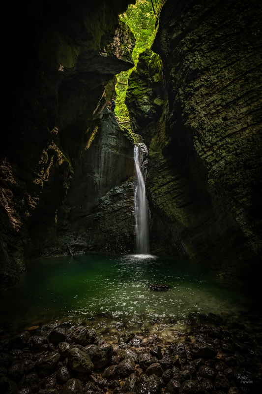 the Kozjak waterfall In order to get a great photo at this waterfall I think it would be best to time your visit to avoid the crowds (including the crowds of cavers arriving on ropes from above the waterfall) and also to consider wading along the bed of the stream instead of following the raised platform, that would have been a practical alternative on the day I visited but may become less practical if the water flow or water level was significantly higher. I had planned to visit the Tolmin Gorge next, but time was ticking and after being sent in another wrong direction by the navigation system I decided that I continue my circuit towards the hotel and get there in plenty time, maybe having a swim before the game. This proved to be a good decision, as the navigation system in the rental car took me on an extreme cross country route winding up and down hills, finally getting to a place where the road I needed to take was closed for maintenance. The detour was extensive and added nearly an hour to my journey. I arrived 3 minutes before kick-off. Still, a good day. The following morning I headed for Jamnik once again, hoping to get an interesting sunrise. The period before the dawn was perfectly pleasant, but not that interesting. No nice colours to be seen, no interesting clouds, no mist... just plain. I decided to wait around for the moment when the sun first cleared the mountains in the background. 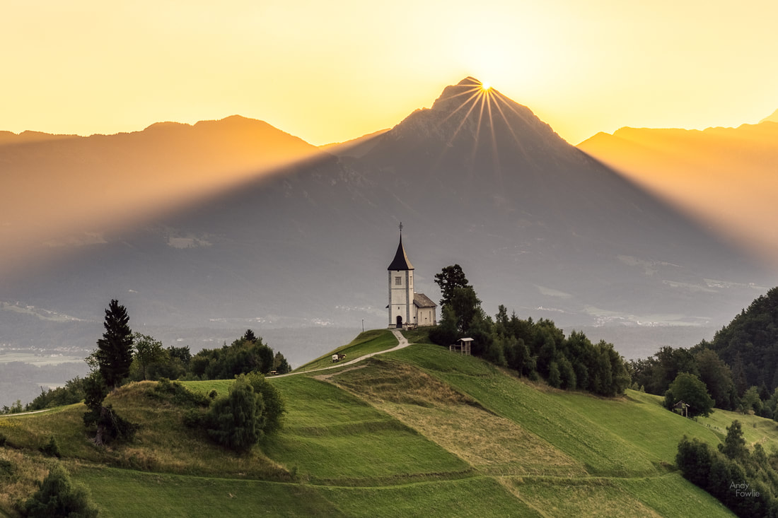 the first rays of a new day at Jamnik After leaving Jamnik, an impractically located church in the middle of nowhere on the top of a steep hill in front of the mountains, I decided to scout a new location. I drove towards St. Tomaz - a totally different impractically located church in the middle of nowhere on the top of a steep hill in front of the mountains. Variety is the spice of life. While proceeding towards St. Tomaz I had a number of navigation related mishaps. In Slovenia it seems that you have perfect motorways and the roads to major towns are very good, but outside that the road quality degenerates very quickly. The navigation data is very noticeably worse than in other European countries, no matter which mapping data you rely on (I saw no difference between Here maps and Google maps). It seems that context data is totally absent. Yes there is technically a road, yes the limit might be 90km/h on that road... but in practice a normal car should not attempt it at all and if you do have an offroad vehicle then it would still not be sensible to try and drive faster than 30km/h. This means that the "what is the best route" decision making is very, very poor. Eventually, after more than an hour of detours and circles, I arrived at St Tomaz, and it was a fantastic place.  A church, on top of a hill, middle of nowhere -> Slovenia! Having found the church itself I tried to make my way to a good viewpoint, this church is better viewed in context, from a distance (in my opinion). Here the navigation outdid itself once again. From my parking space it sent me down the hill again, a couple of kilometres of steep, winding, single lane road... and then had me turn right, right and right again before proceeding back up the hill via the same road to where I had started... in order to continue along a dirt track located 30m from where I had been parked in the first place. The ruts were so deep that the vegetation in the middle of the overgrown track was scraping the bottom of the car... there is no way I was going to commit my rental car to 11km of this before the next turn... so it was back down the same damn hill again to find a different route. Eventually I got the the place I was looking for, on a nearby hill close to Rantovse.  St Tomaz This was a good scouting mission, finding the best angles to shoot the sunrise the following morning. Now there was the simple matter of just driving back to the hotel. Once again the navigation system sent me on a tour of the worst possible roads. After 40 minutes I saw a church and stopped to allow my frustration level to settle down... maybe a prayer would have been helpful also. I saw St Tomaz from the church... it should have been 40 minutes behind me but I could see it sitting there a few kilometres away. Great. The butterflies fluttering around the church garden cheered me up. 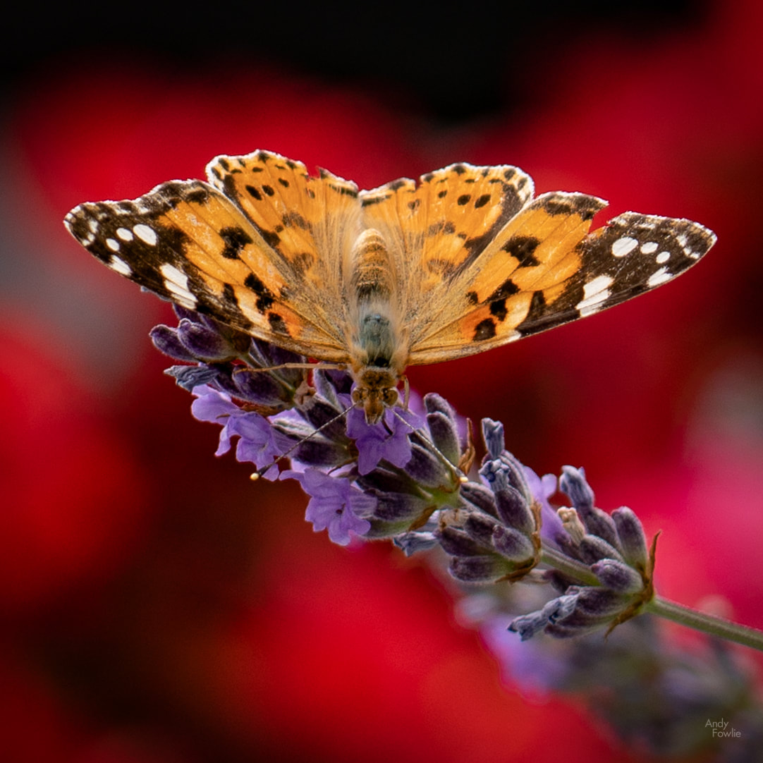 posing in front of a background of red flowers 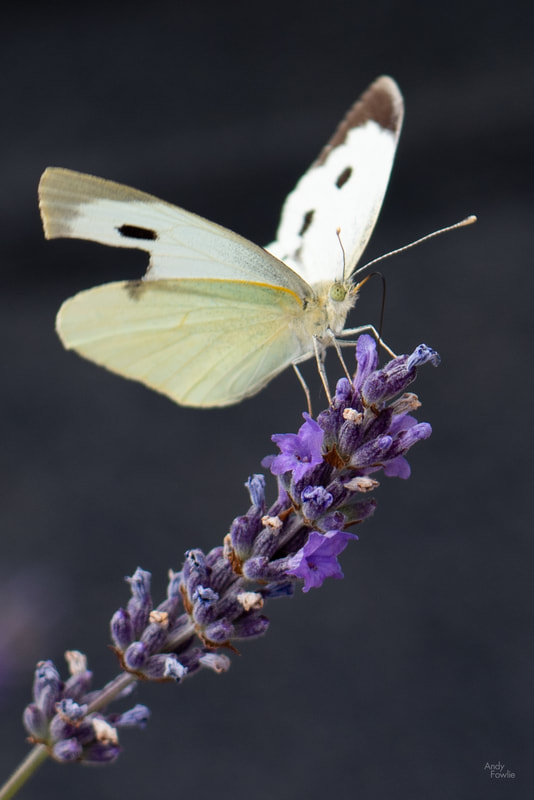 stop showing off... some people can't even touch their nose with their tongue!  a flower Taking personal responsibility for all navigation decisions, I made my way back towards the hotel using the "largest road is quickest even though it says it is not" principle. After a short rest another failed attempt was made to find interesting sunset light at Lake Jasna... once again nothing much happened.  * imagine own sunset colours * A somewhat trying day... but no matter. The following morning I was up at 0315 to make my way back to St Tomaz for the sunrise... and it was almost a success but not quite. There were some nice colours in the sky but the clouds were too big and too dark only starting to thin out when the sun was already well above the mountains.  Fire in the sky at St Tomaz In the right conditions this could be a truly magical place for a photograph, but all you can do is make the best of whatever conditions you happen to get. Sometimes you are lucky, but 95% of the time you just have to make do with something which is not quite what you hoped. In such situations you can anyway enjoy just being in such beautiful places, safe in the knowledge that all the people who are sleeping instead of standing on a remote hill before 0500 are missing the whole thing completely.  a beautiful golden haze For my final hours on this trip I returned to Bled and had a last walk around that beautiful lake, pausing to visit St. Martins church before heading back to the car.  the altar at St Martins church, Bled. Overall this was a really enjoyable trip to a magical country. I hope to return to Slovenia sometime in the future. Thanks for reading! Andy |
AuthorAndy Fowlie See also:
SubscribeEnter your email address to receive notifications of new blog posts
Archives
December 2019
Categories
All
|

- Hub
-
Portfolio
- Flow 2019
- magical Vestrahorn 2019
- Fangorn 2019
- a snowstorm at Kintail 2019
- the village 2019
- a bolt from the blue 2019
- peaceful purple pastels 2019
- a Slovenian sunrise 2019
- the cormorant 2019
- Elgol on the rocks 2019
- weeds 2019
- pretty in pink 2019
- Ritsons Force 2019
- Sakrisoy on the Rocks 2019
- the Clappersgate eye 2019
- the Falls of Falloch 2019
- in the jaws 2019
- the devils teeth 2019
- tranquility 2019
- the old man of storr 2019
- Destinations unknown
- Articles
- Recognition
- Contact
- Store
- About

 RSS Feed
