|
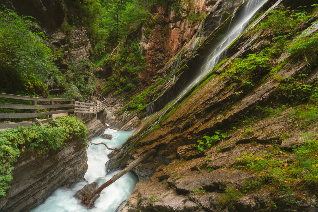
One of the most striking features of the East Anglian countryside is the large amount of windmills and windpumps that are scattered across the whole area, many of them in a good state of repair and some of them still functioning. These mills played a big part in the history of the area, draining many parts of the fens and broads in order to make the area more habitable and workable. One particularly attractive example can be found in the lovely village of Cley-next-the-sea, just along the road from Weybourne where I was staying.  the mill at Cley-next-the-sea Although this charming village has "next-the-sea" in it's name it has not actually been next to the sea since the 17th century, a land reclamation program has meant that the shore is now 3 kilometres away and some marsh land fills the space. The huge reed beds in this area make a perfect sanctuary for a number of bird species and a lovely area to walk through on some raised embankments. The village itself is also interesting, there are a number of houses which are constructed from flint (a traditional material in Norfolk) and also many buildings which are influenced by the local wildlife in one way or another.
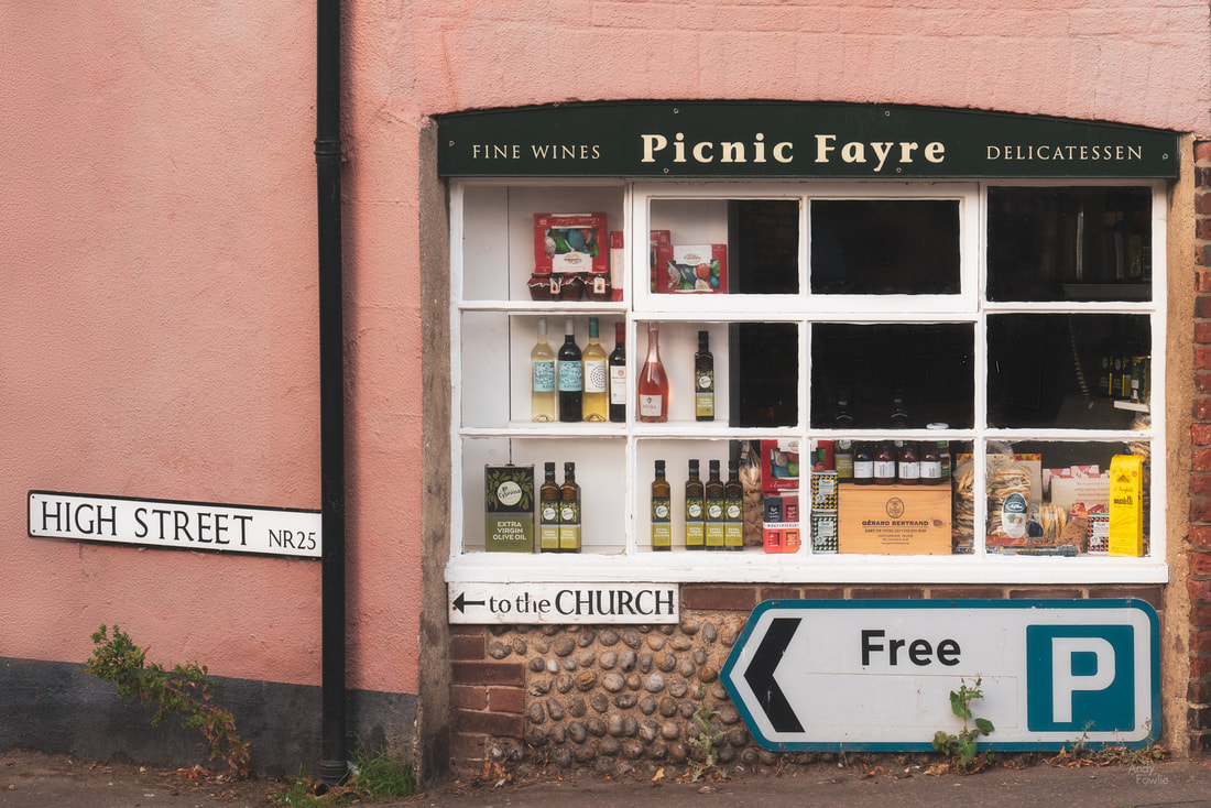 a local shop A 20 minute drive from Cley-next-the-sea takes you to Holkham Nature Reserve, a beautiful expanse of dunes and woodland stretching along the coast. I took a peaceful early morning walk along the Holkham beach to another "-next-the-sea". The beach at Wells-next-the-sea (which is still actually next the sea) contains a huge row of over 200 beach houses all next to each other. The sunrise on this day was one of those "blue sky, no clouds and nothing happens" afairs, but it was anwyay a wonderful way to start the day. There is a special satisfaction to be gained from a few hours of activity before breakfast. 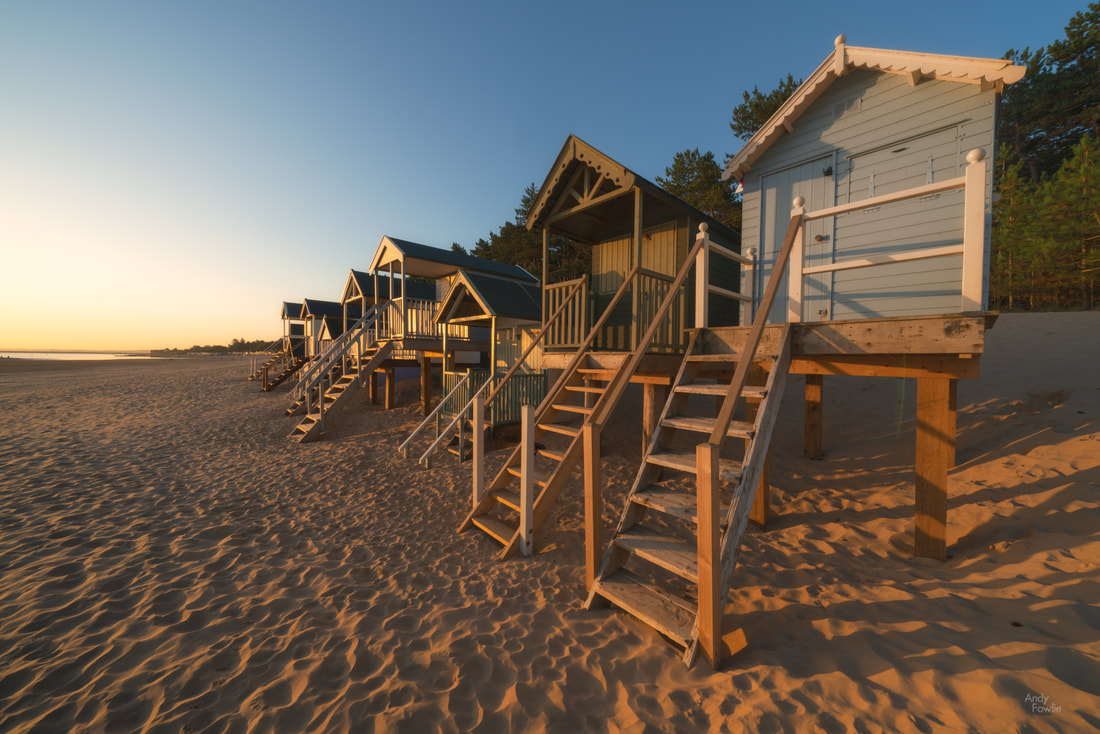 beach houses at Wells-next-the-sea Many parts of the UK are littered with grand old houses in the middle of huge estates, a reminder that there have always been those that have and those that have not. In modern times a great number of those are opened to the public, often under the management of the National Trust. I made my way to Felbrigg Hall for a morning walk through the woods. 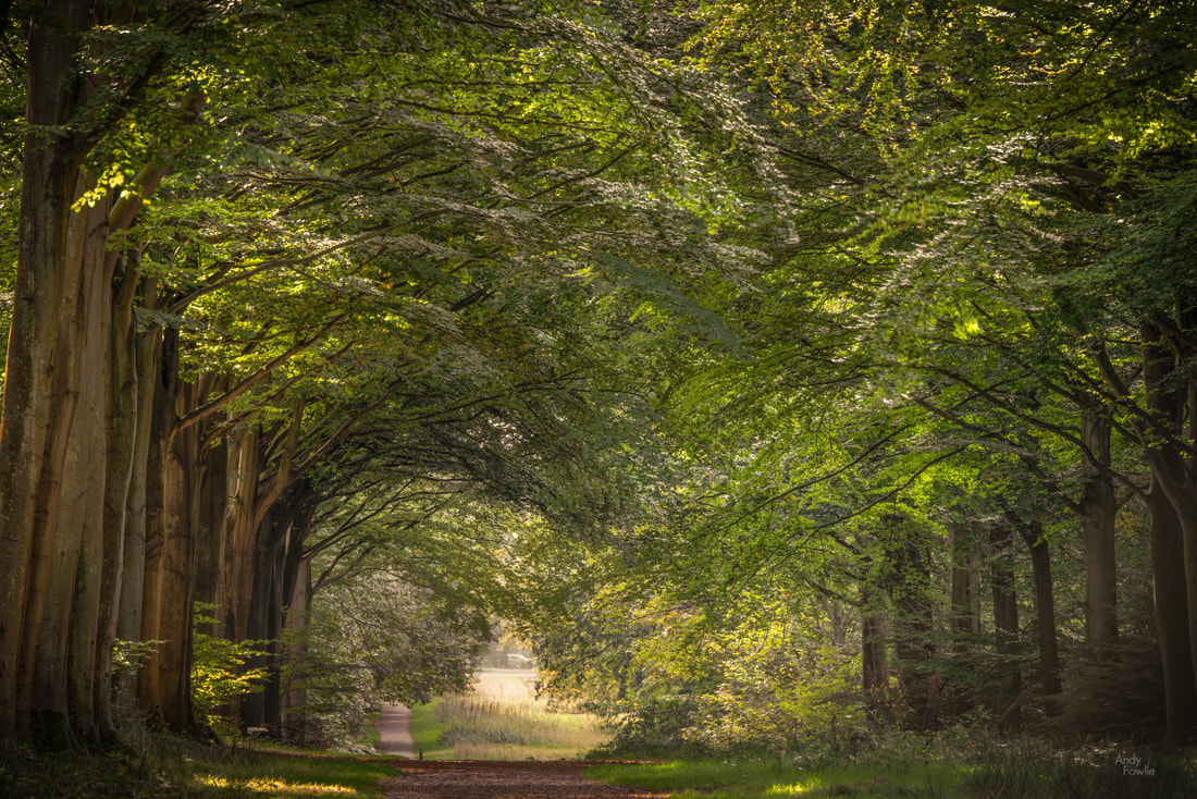 a beautiful avenue Encouraged by the Felbrigg experience I made my way to the Blickling Estate. The National Trust does a great job of maintaining all of this cultural history and rural beauty for the public good, but all the good work comes at a cost. I have donated an inordinate amount of funds to the National Trust this year for parking and entry fees on my multiple UK trips, there is always a noticeable fee to park and an even more noticeable fee to enter at different destinations. All of these fees seem more-or-less reasonable in isolation but if you are taking in a number of venues in a day then it starts to be a burden. Blickling is another enormous estate, covering 1861 hectares, and it is full of interest and beauty in it's buildings and gardens. At the time I visited there was very harsh daytime light so it was not optimal for photography... wrestling with the images I took on that afternoon took me to some strange places.
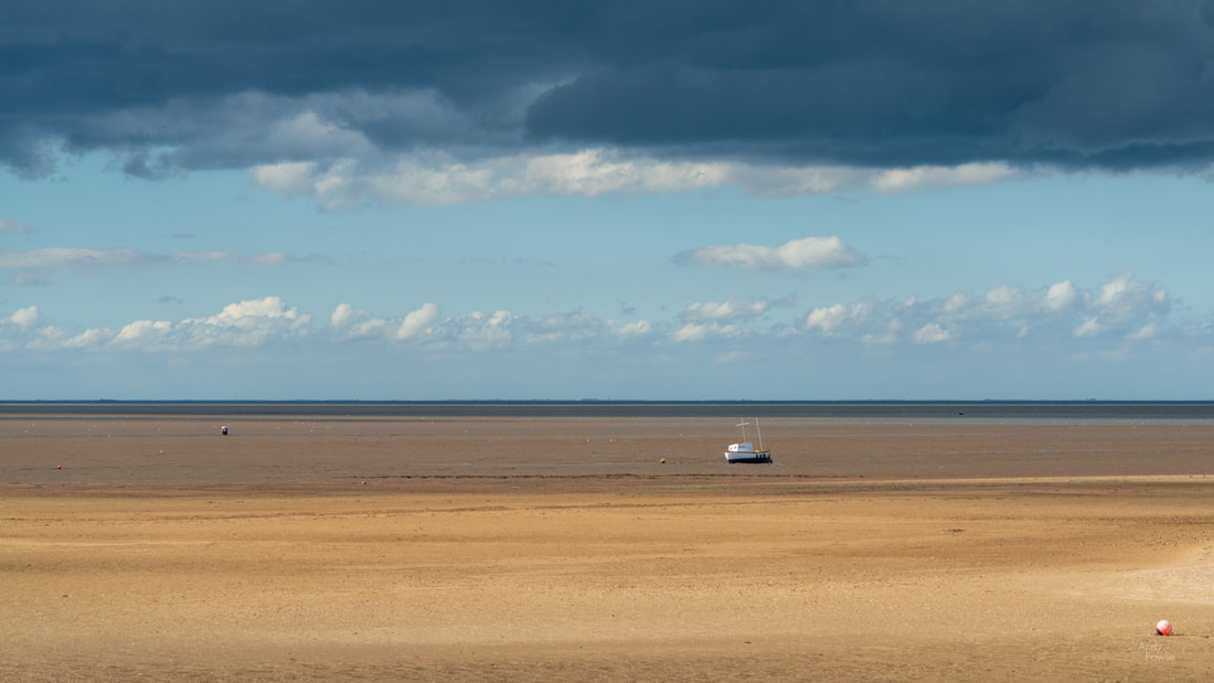
you are welcome / i am sorry (delete as appropriate) Back in the real world my next destination was Thornham, another beautiful area with channels through the reeds, old abandoned boats and buildings, flanked by dunes covered in marram grass, leading out to a lovely beach. 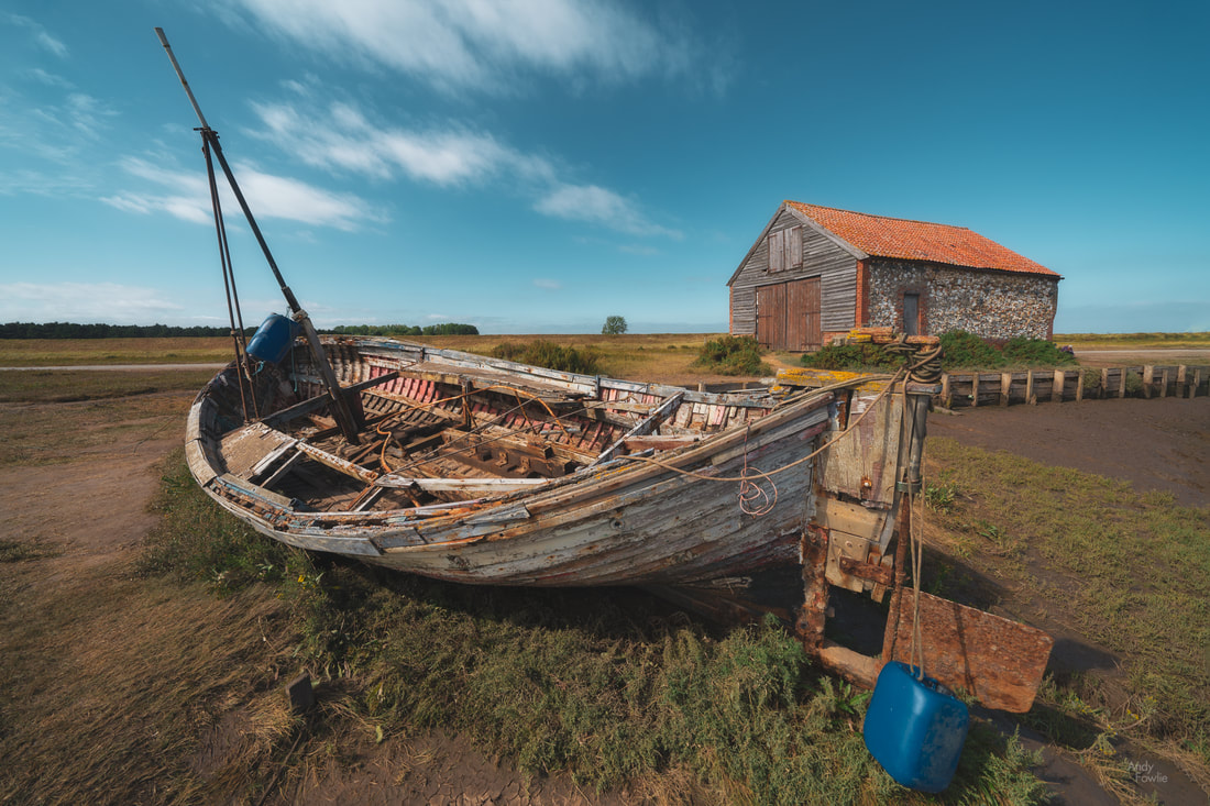 a memorial to voyages past East Anglia is generally very low lying, meaning that photographic interest needs to come from colours, patterns, shapes, textures and objects rather than rolling hills or strong elevation changes. This presents a different and interesting challenge. 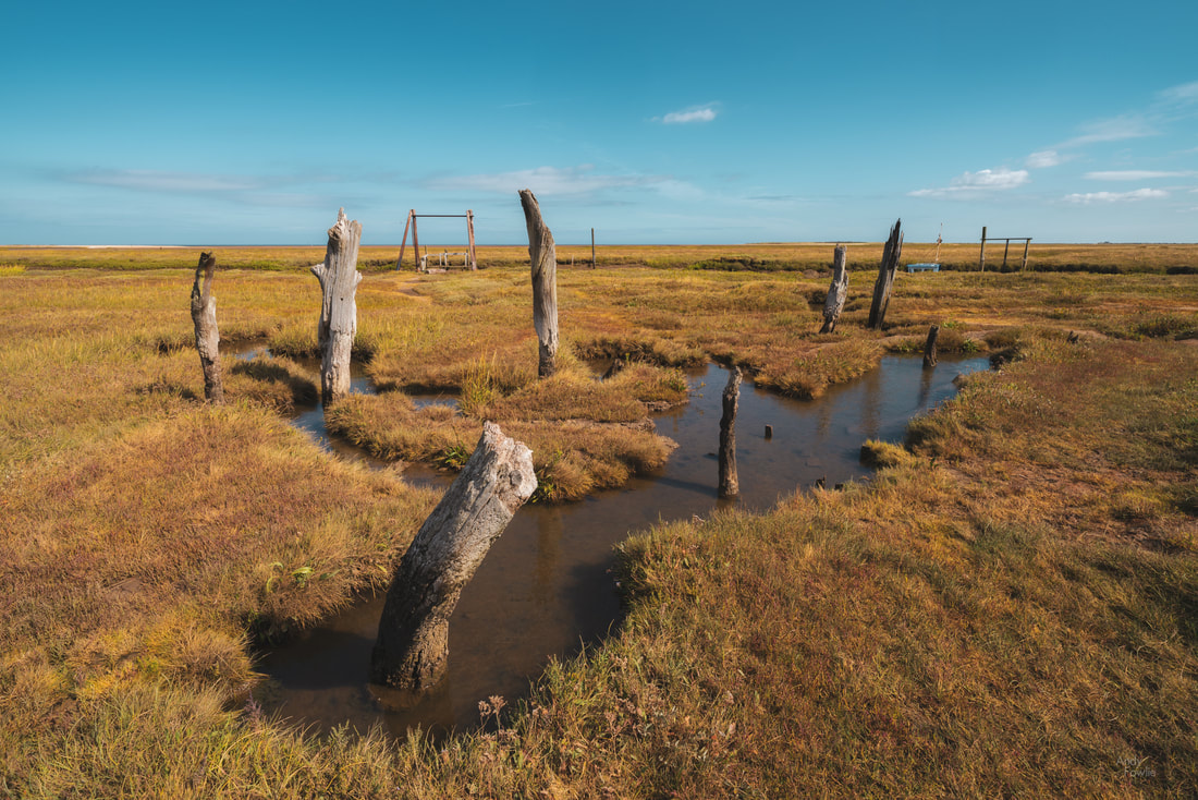 some curious tree stumps decorate a marsh pool The village of Blakeney is a perfect example of a Norfolk village, narrow roads lead past traditional flint cottages to a slipway full of boats and a marshy area reaching out to the sea. I spent my last North Norfolk evening watching the sun go down at Blakeney. 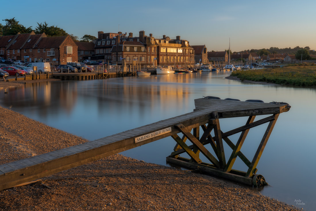 Blakeney Last Light After taking the shot above I went walking through the marshes, looking for compositions, none of which made the final selection from this trip, before returning to almost exactly the same spot after dark (note the difference in the tide). 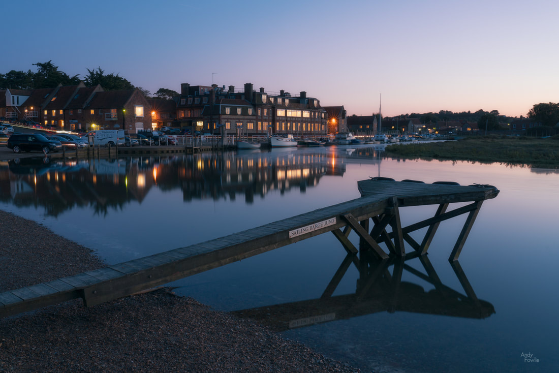 Blakeney Twilight To conclude this blog episode (episode 65 in case anyone was wondering) I will return to where i started. My last North Norfolk sunrise was viewed across the reed beds at Cley-next-the-sea. 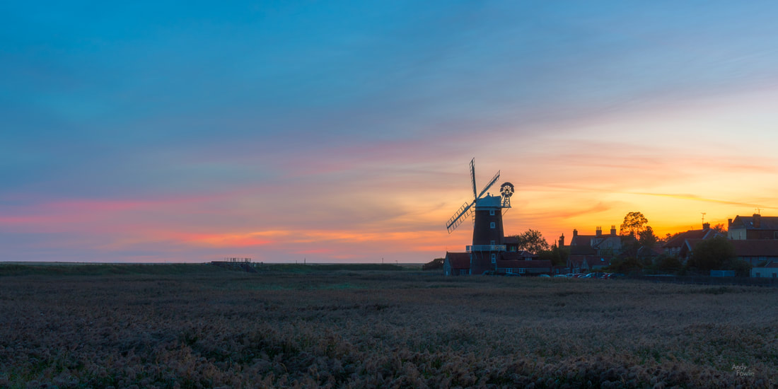 a new day at Cley I walked through the village and back to the area near the mill. A bench was handily placed in a perfect spot for observing how the light developed as the day began. 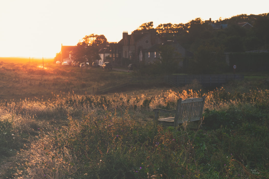 Another North Norfolk day was under way.
Until next time, Andy
3 Comments
Earlier this autumn I made my first visit to East Anglia, a fascinating area on the east coast of England. My first days were spent in North Norfolk where I had a very enjoyable time photographing the beautiful coastline and rural scenery.
My base for these first days was The Maltings Hotel in the village of Weybourne, a location which turned out to give me good access to many of the places I was interested in. When visiting a totally unfamiliar area the selection a perfect place to stay requires at least a small degree of luck. I arrived in the late afternoon and decided to head down the coast to nearby Sheringham to watch the sun go down. 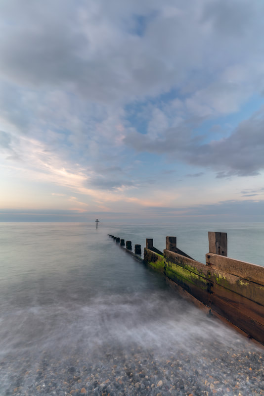
a beautiful evening on the pebble beach at Sheringham
After a good night's sleep I headed towards the town of Cromer, hoping for some kind of sunrise. The weather however had different ideas. Overall on this trip I had much kinder treatment from the weather gods but this morning was quite dreary.
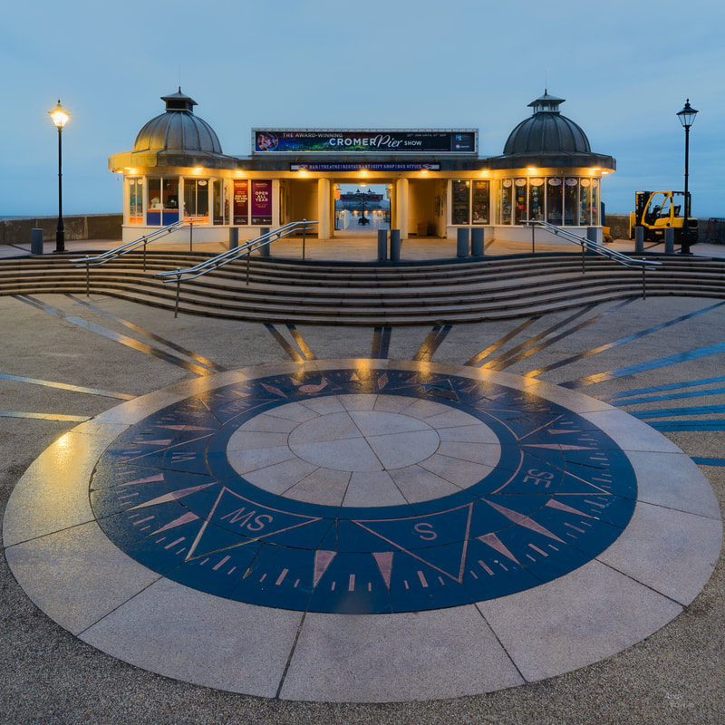
The entrance to Cromer pier
The impressive pier at Cromer is 140m long and was opened to the public perhaps in either 1901 or 1902 (depending on whether one of the conflicting references in wikipedia is correct). A pier is always a promising subject for a photograph, the long straight design of most piers provides strong leading lines if you wish to make sue of them. At Cromer there was too much clutter and too much construction ongoing, slightly detracting from the possibilities for a good shot.
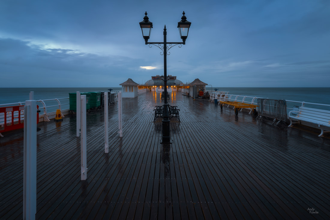
not many people around at 0600
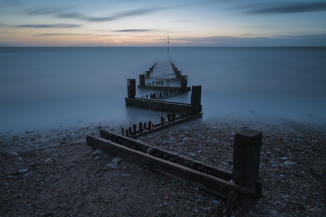
Along the coast from Cromer you can find the small village of Overstrand where a steep paved path leads you down to the sea front and a series of erosion defences. I have spent quite a lot of time on the coast in my 2019 trips and I have started to get a better feeling for how I like to capture different scenes. The whole east coast of the UK is affected by strong tides and in many places coastal erosion is a concern. The daily comings and goings of the tide create an ever-changing landscape, sometimes peaceful, sometimes violent, almost always interesting in one way or another.
On this occasion, in beautiful soft evening light, I decided that a dreamy looking long exposure would be the best approach to the scene, complementing the soft colours of the scene. This 404 second exposure would be one favourite from the trip. 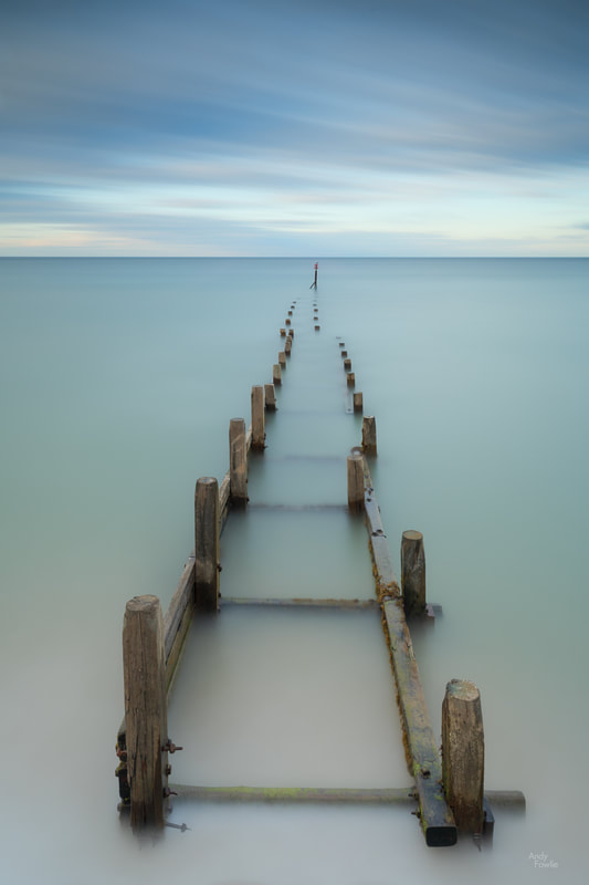
404 peaceful seconds at Overstrand
To the north of East Anglia, and to the south of Lincolnshire, you can find The Wash - a huge, shallow, square-ish estuary which covers an area of about 620 square kilometres. The four corners of the square are roughly defined by the towns of Hunstanton and Kings Lynn (on the south side in East Anglia), Boston and Skegness (on the north side in Lincolnshire.
On a blustery, bright (and slightly wild) day I headed for the nature reserve at Snettisham where I planned to see what kind of birds I might be able to find resting in the huge tidal expanse of The Wash. with some luck I was able to find three species that I had not previously seen, taking my total number of photographed species to 208. 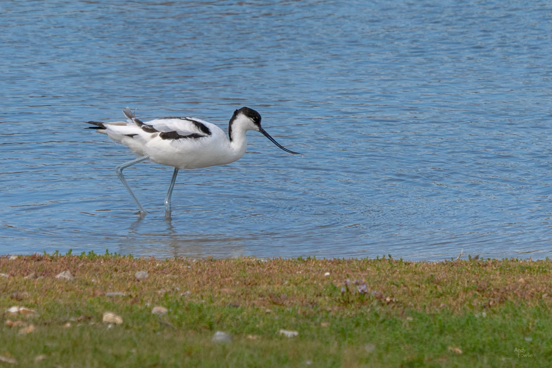
an Avocet wades in the shallows of a small lake
The extent of the change from low tide to high tide in The Wash was remarkable. I could see (from the wet mud, jetties and boats resting on the ground) that I was next to the shore, but the shallow mud flats extended beyond the horizon. The water would return in a few hours, but for the moment it was completely out of sight. A number of Little Egrets patrolled the muddy expanse, searching for delicious(?) morsels.
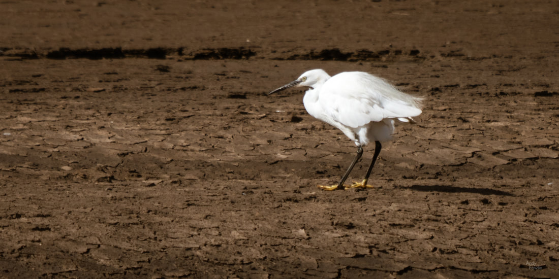
a Little Egret on mud patrol
Perhaps the biggest prize of the day was the chance to see some Eurasian Spoonbills flying overhead - huge and impressive with their unusually shaped bills. It would have been nice to have had a long telephoto lens with me to try and get a better picture of these amazing birds but I did the best I could with the 100-400mm zoom.
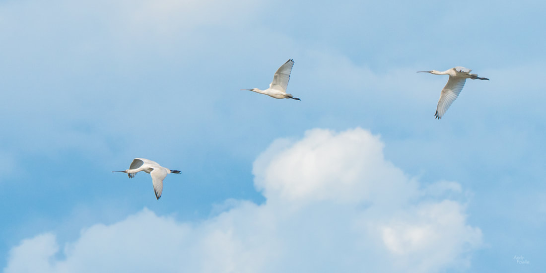
Spoonbill Squadron
I walked a considerable distance on this day, in high winds, ending up with a feeling like I had been in a bit of a battle, somewhat tired but in a good way. One of the best things about landscape or nature photography is the excuse it gives to spend extended periods wondering around in the outdoors.
free parking
After my enjoyable day in Snettisham I made for the seaside town of Hunstanton where I hoped to find some good compositions for the sunset session. At the north of the town you can find Old Hunstanton beach, a more natural and wild area with beautiful dunes and geologically interesting cliffs. On this day the wind was being put to good use for leisure activities.
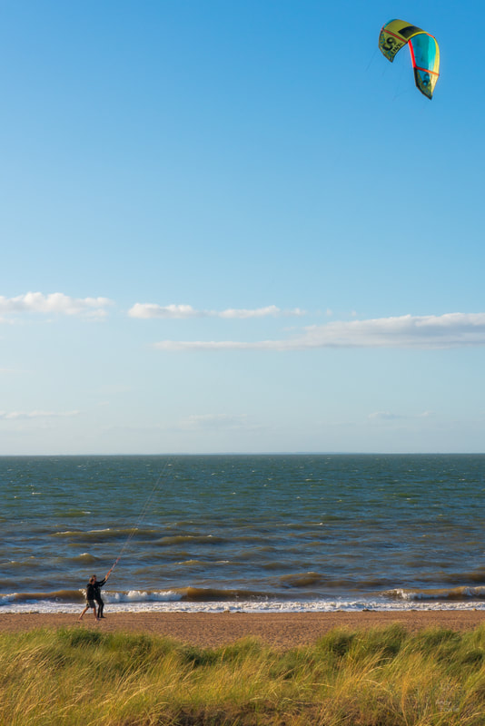
I am sure they had this under control...
The tide was rising at this point and the water prevented access to the foot of the cliffs, so I headed instead for the sea front promenade in the town and looked for a way to photograph the sea defences as the sun started to set. Having got myself into position I had some time to kill before the best light so I bravely decided to take my 2019 selfie to pass the time (I really don't like to have people in my pictures, least of all myself).
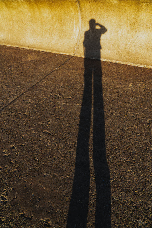
selfie 2019
The coastal defences along the sea-front have an interesting zig-zag configuration and I thought that this made for a compelling subject. I do not normally want to have the sun in the frame when making landscape photographs but once in a while i think it is healthy to consider doing something a little differently.

as the sun sets
I stayed in position and watched as the light gradually changed, shooting a series of very long exposures (5-10 minutes). I like the calming effect that this produces in the resulting images and there is something satisfying about the picture being created over an extended period of time instead of being all done in a fraction of a second.
the Hunstanton blues
As the gloom descended I decided to make my way back to the Old Hunstanton cliffs and see if I could manage to navigate my way along the beach in the dark in order to get a shot of the cliffs.
In such situations I have found it better to allow my eyes to get used to the darkness (instead of using a torch) and due to my sensible (cowardly) nature I don't proceed if I feel that anything is risky. On this occasion I was able to make my way along the beach easily enough and was confident that it would be safe to make my way back when it was even darker, the route was mostly sand or pebbles and the rocky areas were not slippery. Importantly the tide was on it's way out (and would not be back until morning) so there was no possibility of being surprised by an incoming tide. 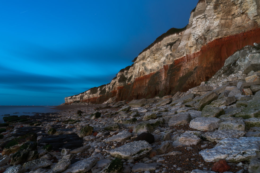
the red and white stripes of Hunstanton's chalk cliffs (a 14 minute exposure in almost total darkness)
The unusual red stripe on the cliffs is caused by iron deposits staining the limestone, this rock was formed in layers of sediment over a prolonged period, on top of a layer of Carrstone (sandstone bound together by iron oxide). The end result is quite striking.
My pictures and thoughts from East Anglia will continue next week. Thanks for reading! Andy Recent Posts
Any visit to the Bavarian Alps is not complete without having a look at one of the many castles that look proudly down from prominent positions on the mountainside. On my short September trip to Germany and Austria I made a point of visiting three different castles, despite the weather (as usual) making it's best efforts to discourage me.
The first of my castles was on the Austrian side of the border, Hohenwerfen Castle is an 11th century fortress overlooking the market town of Werfen. 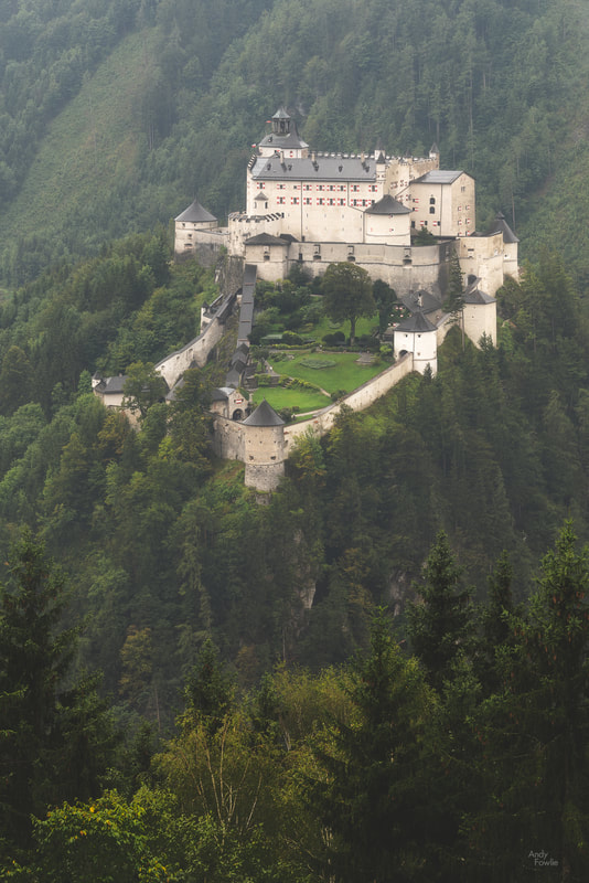
Hohenwerfen Castle
I had the impression that the castle was best seen from above so I made my way up to the overflow car park at Eisriesenwelt (an ice cave on the mountain opposite) to look for a vantage point. I had the idea that I might also visit the ice cave but once I understood that all photography was prohibited there I rather lost my enthusiasm.
The weather on this particular day was relentlessly miserable - windy, raining and cloudy - so i decided that the best approach would be to capture some timelapse footage of the castle and the nearby forest while the low clouds rushed through the scene.
The mountains and hills near to Werfen are not amazingly high but they rise very steeply which makes for some impressive views, but the thick cloud made it quite difficult to make much of the opportunity.
mountains in the mist
I returned to Berchtesgaden (after visiting the Erlebnis-Therme Amadé to warm up a little) and drove up to the summit of Rossfeld (the subject of my previous blog) to see whether there were any views through the clouds. The high vantage point allowed for some panoramic views as usual and there were just enough gaps in the cloud cover to allow some shooting.
The dreary weather produced scenes which were rather devoid of colour so I decided to embrace that when working with the images and aim for an "aerial footage from World War Two" kind of look. 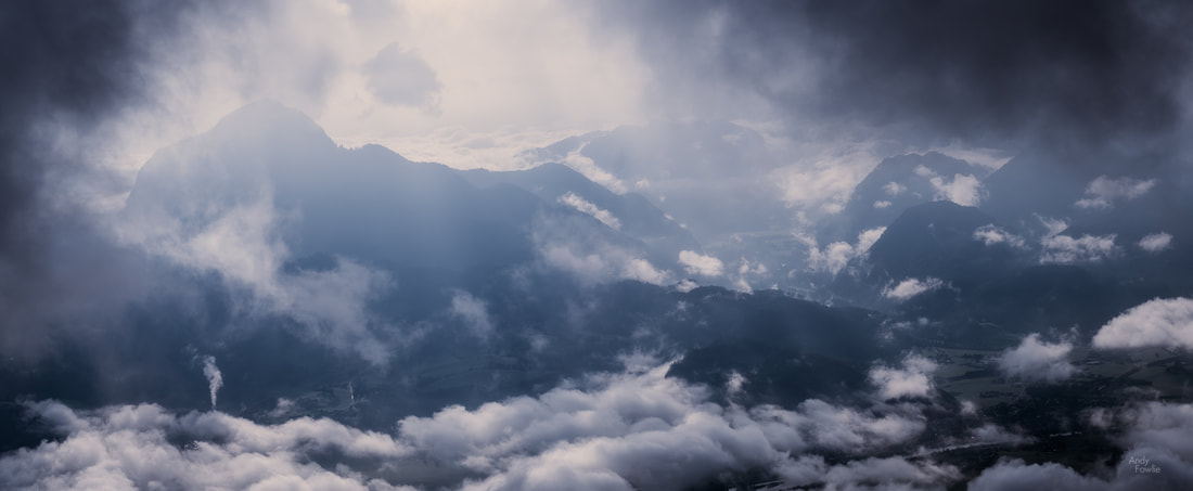
"reconnaissance" - a view of the Salzach valley from the top of Rossfeld.
The following day was slightly less wet but still quite overcast. I decided to visit the Wimbachklamm gorge for the first time in a few years.
The particular geology of the Bavarian Alps seems especially likely to generate spectacular gorges such as this, but perhaps it is just the case that they have just been made more accessable to visitors in this area than many others. 
the glacial waters leave the gorge
Shooting in a gorge such as this is a challenging activity. Typically such places are accessable only via a narrow ledge or an artificial walkway attached to one of the gorge walls. There will be a sturdy barrier to prevent dangerous falls but usually the path itself is pretty cramped and there is a flow of people along it. Setting up a tripod is likely not a luxury that will be available for you. Another constant difficulty is the spray from the rushing water, this requires attention between shots and also makes changing lenses a dangerous activity (you do not want the camera sensor to get a bath every time you change a lens). Being properly prepared and being able to adapt to what you find becomes much more important than usual.
Wimbachklamm
As is often the case in places like this I found myself looking for more intimate scenes. Selecting a single interesting detail or a tiny fragment of a wider scene is an excellent way to produce images that are not like every other image that has been taken at a particular place. "Different" is quite easy... but when you also want the image to look good it gets harder. A good portion of the images that I come up with in this way seem to fall flat with an audience, but that is fine, in the end I think it is more important to try to satisfy myself rather than others when I produce my images.
the eye of the storm
Another of the beautiful highlights in the Berchtesgaden region is the lovely Hintersee lake. This is another place that I have returned to many times, as much because I love to be there as for any photography related reasons.
The lake itself is shallow and beautifully clear, filled with green-blue alpine meltwater, it is surrounded by mountains and is relatively sheltered. Perhaps those factors are helpful in some way for "trees growing on a rock in the middle of a lake", or perhaps it is a coincidence, but either way Hintersee has plenty such trees adding to it's charm. 
the Hintersee blues
Hintersee is a popular destination for photographers and hikers, a number of trails lead to and from this lovely lake and it is usually relatively easy to park.
life clings on
My few days in Berchtesgaden were soon over and I made my way to my next home base in the Austrian village of Reutte. Upon arrival I found the owner in a state of considerable distress because my room was not ready - the indiviuals who had checked out earlier in the day had left the place in a truly terrible state. Sometimes I really wonder what is wrong with people that they can act without basic respect for others. The owner kept mentioning the nationality of the people who had left the mess, but I do not think that any country is entirely free of assholes so I do not see that it is relevant to the story. We agreed that I would delay my check-in by a number of hours.
My reason to be near to Reutte could be found just across the border into Germany. The village of Schwangau, near to Füssen, is the location of a number of spectacular buildings. Lets start with the very beautiful Hohenschwangau Castle. 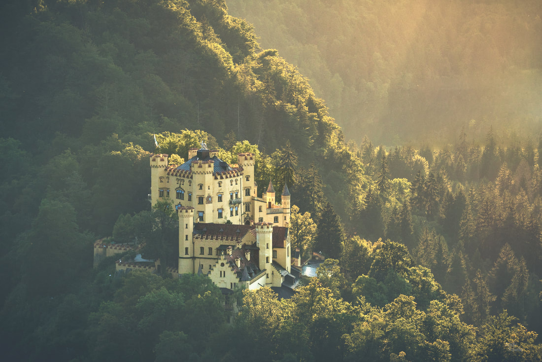
Hohenschwangau in late afternoon light
A castle has been on this site in the Allgäu Alps for many centuries, the earliest known records mention it's presence in 1397, but by the time the site came into the possession of King Maximillian II of Bavaria in 1832 it was in a dilapidated state. Maximillian began construction of the present day castle in 1833 and it was completed in 1837 with further additions being added periodically until 1855. This beautiful and perfectly situated castle was Maximillian's official summer and hunting residence.
My Finnish readers will be familiar with the attraction of a summer cottage, something which is traditionally passed down through the generations. Bavarian castles are similar, but Maximillian's son and successor King Ludwig II was not satisified enough with the castle he inherited in 1864. Construction of his own castle, Neuschwanstein, began in 1869, funded by his personal fortune and some personal loans. 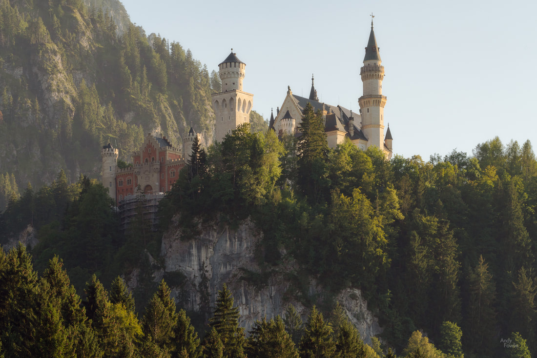
Neuschwanstein castle
The castle is a magnificent sight from the village below, overlooking the area from it's perfect vantage point, but even better views are to be found by making the steep hike up to the Marienbrucke bridge, crossing the wobbly bridge (nervously in my case), and continuing up a mountain trail for a while. The view of the castle with the village in the background is stunning and there are also clear views of the mountains to the south of the castle.
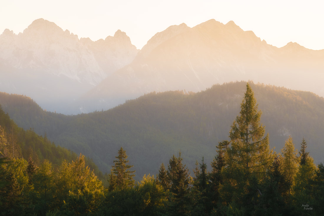
the afternoon sun bathes the mountains in gold
Neuschwanstein Castle has always been a magical place for me, having visited it as a 3 year old in 1978. It was nearly 40 years before I returned for a second look (a first look with my camera) and I have returned a couple of times since then. The castle itself is a major tourist attraction with more than a million visitors every year, so you will not get the place to yourself, but if you aim for sunrise or sunset times then you can get good access to the different viewing locations.
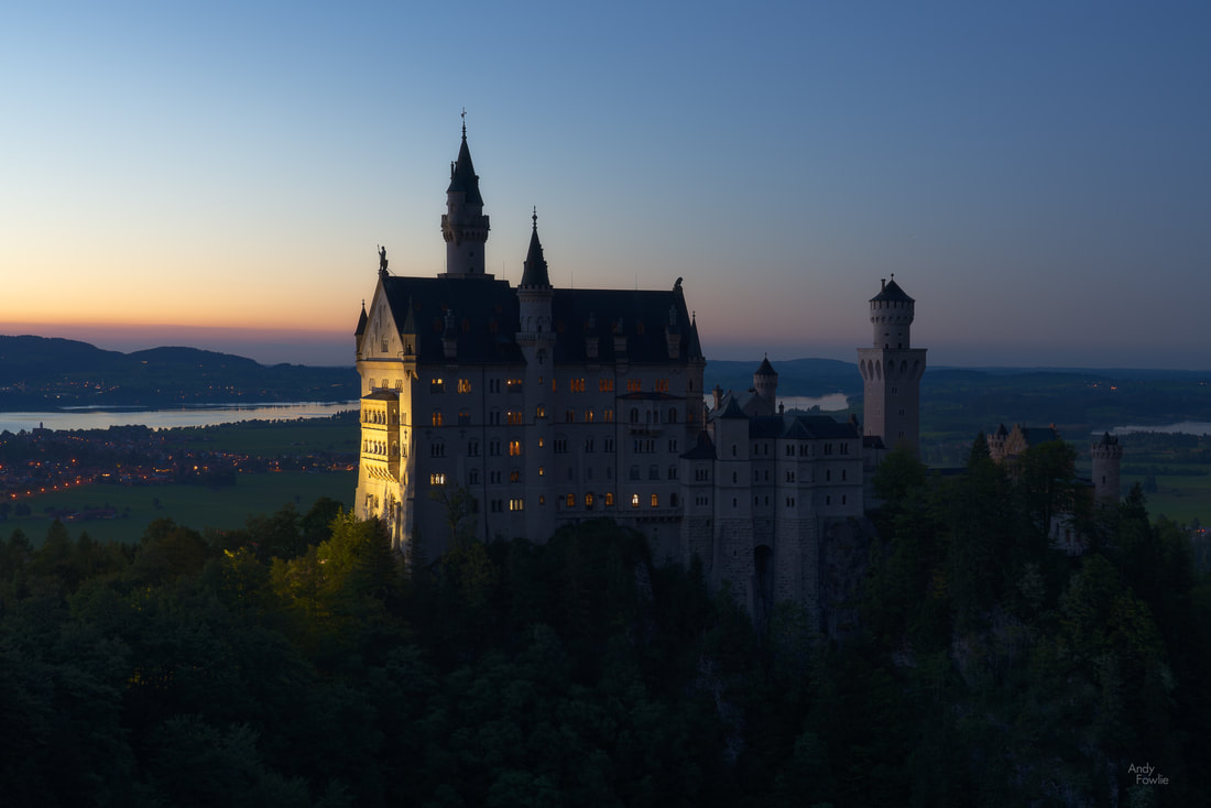
Neuschwanstein after sunset
On this particular visit I enjoyed weather which was firstly too pleasant and then too unpleasant to be ideal for photography, but I still very much enjoyed the experience.
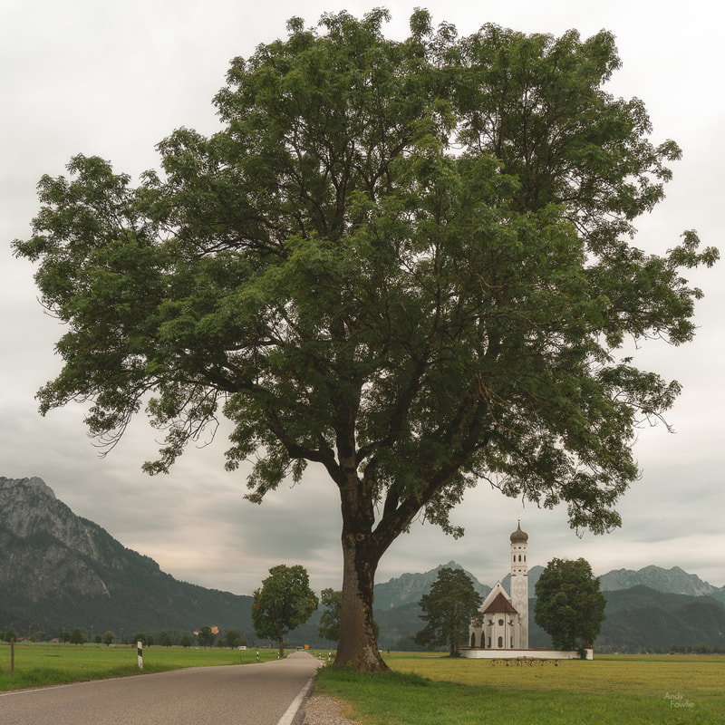
Another grand building, down on the valley floor, is the lovely Pilgrimage Church of St. Coloman, named after an Irish monk who stopped at the site on the first stages of his ill-fated 11th century journey to the Holy land (he was hanged in Austria shortly afterwards having been thought to be a spy due to his strange appearance). 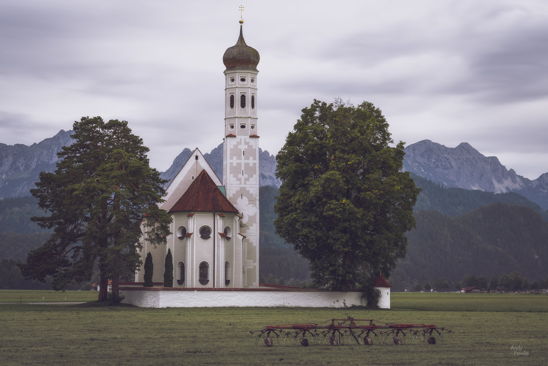
St. Coloman
I have seen beautiful photos of this church, it really suits a snowy winter scene, but every time I have attempted to photograph it the weather has been fairly miserable. When the light is not cooperating then some other tactics are needed to bring at least a little interest to the photographs.
another local attraction - a truly enormous tree
On my final day of this trip, the weather was quite horrible - hammering down with rain, quite windy, and not very good visibility. When trying to photograph Neuschwanstein these conditions are actually very interesting, the castle itself is right around the cloud line on the most miserable days and this can give a deeply atmospheric feeling to any images you might capture before you get completely soaked through and miserable.

Mystical Neuschwanstein
I spent a most enjoyable couple of hours in the meadows near to the Tegelberg cable car shooting timelapse footage of this castle in the clouds. Although it was very wet it was not very cold so I decided to use my waterproof jacket to protect the camera from the rain instead of protecting msyelf, accepting that I would be soaked to the skin as a consquence.
I have always loved spending time in Bavaria, and I hope I will have many chances to be there again.
I would like to thank all my readers for supporting my blog with their likes, shares and comments, I appreciate it very much. Until next time, Andy You can also find me here...
Recent Posts
I am not sure if I will still have any readers after offering extensive thoughts on the art of cricket commentary in my last post, but if anyone ever reads this then please know that I am most grateful for your patience. Having left Snowdonia behind I made my way north and west to spend a few days on the island of Anglesey. Anglesey is a significant chunk of rock (about 715 square kilometres in area) just off the west coast of the Welsh mainland and it can be reached by road using either the 19th century Menai Bridge or the 20th century Brittania Bridge, both of which cross the Menai Strait just to the west of the city of Bangor. The first location i visited was Penmon Point, at the eastern extreme of the island, here you can find fresh air, sea views and pleasant walks while the Pilot House Cafe can satisfy all your on-site refreshment needs. 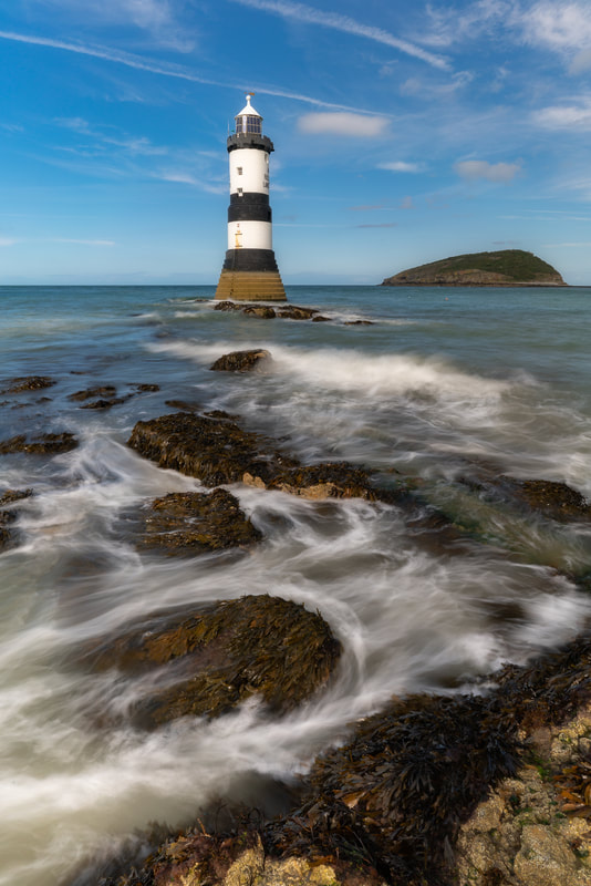 Penmon on the rocks Lighthouses can make for interesting photographic subjects, often providing the vertical element in an otherwise level environment and frequently positioned in slightly wild locations, surrounded by rocks, cliffs and crashing waves. This would not be the only lighthouse of my time in Anglesey. 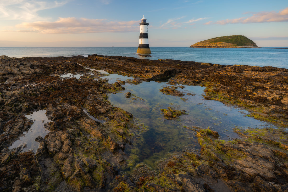 the evening sun bathes the rocks in golden light When planning my trip I had decided that two nights would be spent in Anglesey, meaning that I had an arrival day, a full day and then a departure day. My full day in Anglesey just happened to coincide with the arrival of a major storm. There was fairly persistent precipitation to deal with but the bigger photographic difficulty was caused by monumentally strong winds (67mph = 107kmh =30m/s). Tentatively I headed out into the storm, slightly comforted by the fact that the chances to get my destinations to myself were significantly higher on a day like this. After a completely miserable "sunrise" at Penmon and a restorative breakfast the first location of the day was the old copper mine at Parys Mountain. At a location such as this, a massive open cast mine, there can be some challenges to understand how to capture the character of the place in a photograph... in essence the location is just a huge shallow hole in the ground. To me the most interesting aspect of the scenery was the amazing colours of the soil and sediment, caused (as far as I can find out) by the presence of metallic oxides. The wind was far too strong for even a heavy tripod and the driving rain was an impediment for shooting in many otherwise possible directions so I was reduced to capturing quick hand-held shots inbetween attempts to clear the moisture from the front element of my lens. It is both a benefit and a matter for some regret that i have had so many opportunities in 2019 to develop such techniques. 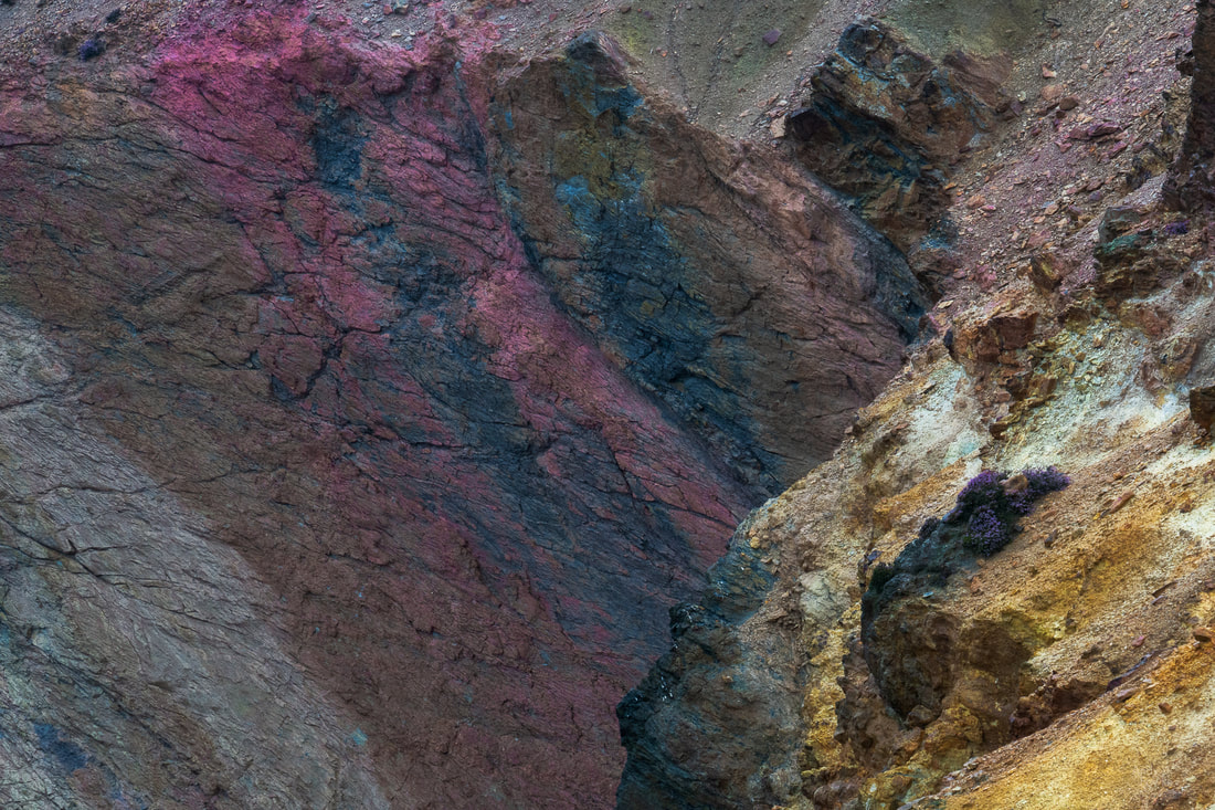 a geological rainbow Despite the weather Parys mountain was a most interesting place to visit. I do enjoy being out and about at interesting locations no matter what the weather conditions may be and I expect to encounter a variety of conditions over time, 2019 has however been remarkable for a lack of variety as heavy rain and strong winds have been a constant companion. I shall endeavour to ensure that my posts contain something of interest (ok, ok, no more cricket stuff) in addition to complaints about the weather. My journey continued and I drove towards Holy Island (a 39.4 square kilometre island located just west of the island of Angelsey, which is located just west of the British mainland which is an island just to the west of the European mainland) from where I intended to photograph the lighthouse at South Stack... which is located on a tiny island just to the west of Holy Island. The path leading down the cliff side to South Stack from the car park is completely exposed to the worst of the elements. The stone walls to the side of the path protect you well from any accidents, but the wind made shooting of any kind exceptionally difficult, 95% of my attempted pictures ended up as a blurry mess. 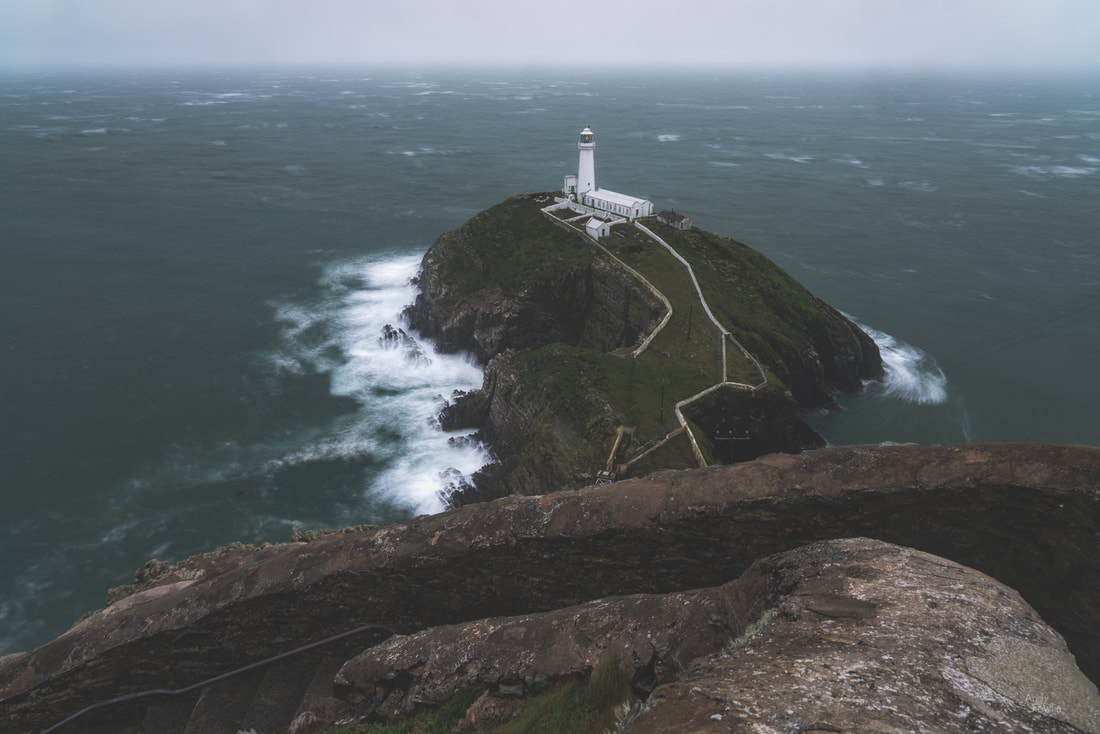 a moody day at South Stack I resolved to return at sunrise and try again, despite the fact that I would need to set my alarm for 0345. I made my way back in a southerly direction along the east coast of Anglesey, towards a place called Llanddwyn Island. The island can be accessed on foot along the nearby beach but it is cut off from the mainland at high tide so some sensible planning is required in order to reach it and leave it again without having to wait around for a few hours at either point. This island and surrounding area have many paths which lead through the beautiful dunes and you can also find yet another lighthouse, the Twr Mawr lighthouse, built in 1837. 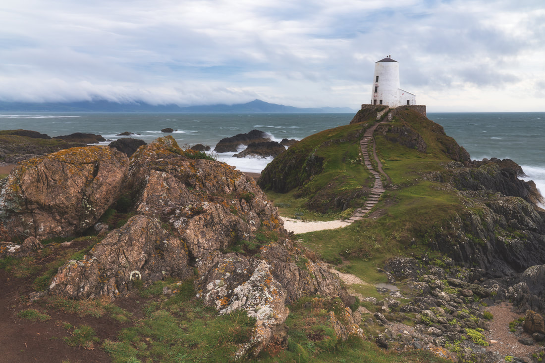 classic view of Twr Mawr lighthouse, with the mountains of Snowdonia shrouded in cloud in the background The afternoon weather was at least slightly more pleasant, the strong winds persisted but the rain finally gave way to a mixture of sunshine and cloud which can be an attractive combination.  a view from the island back towards the mainland I did make it to South Stack the following morning, well before the sunrise, but I was not rewarded with anything particularly interesting in terms of light or colours. It was at least much easier to stand up and importantly to use a tripod seeing as the storm had finally moved on. I believe that sunset might be a better proposition at this spectacular location on a suitable day.  Leaving Anglesey behind I continued my journey, a few days in South Snowdonia, based in a small village near to the town of Harlech. The weather took a temporary turn for the better and as I had a look round the town of Barmouth in the afternoon it was possible to believe that it really was August in Wales and not November in the Arctic. 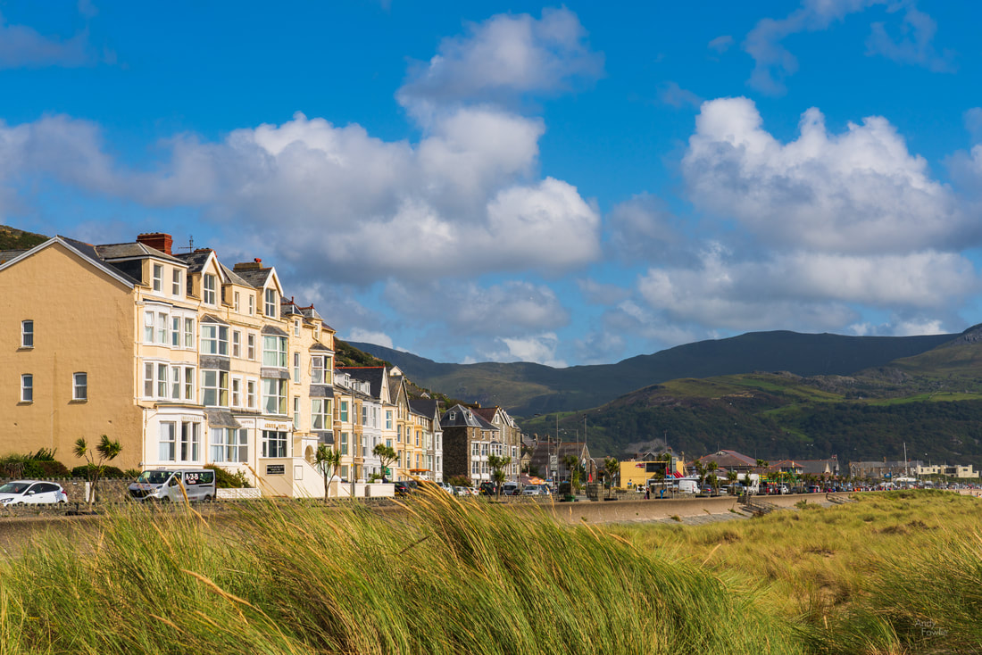 beachfront properties in Barmouth Harlech itself is a nice old town perched on a hillside with a very beautiful sandy beach which stretches for many miles and a mountainous landscape of dunes covered with marram grass. The famous golf course played over by the members, guests and visitors of Royal St. Davids Golf Club occupies some beautiful links land adjacent to the dunes and offers some nice views towards the other main highlight of the town, the castle. 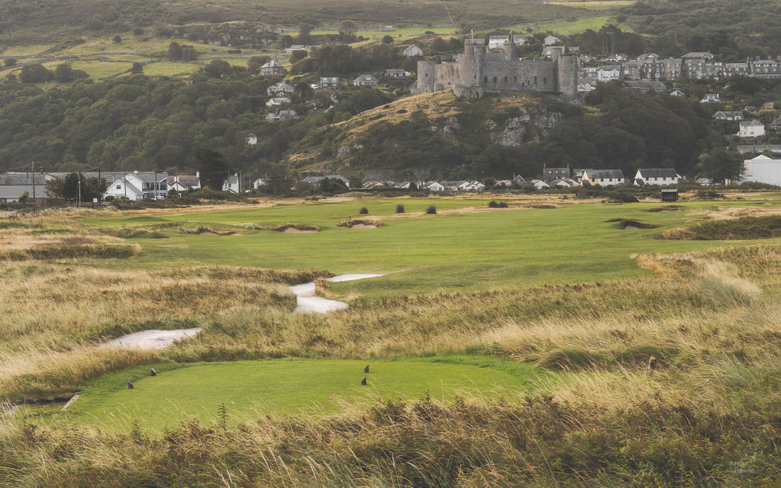 the 12th hole at Royal St. David's, a par 4, takes you back towards the magnificent castle There are a few possible vantage points within the town from where you can get a good view of the castle with the mountains of Snowdonia in the background. 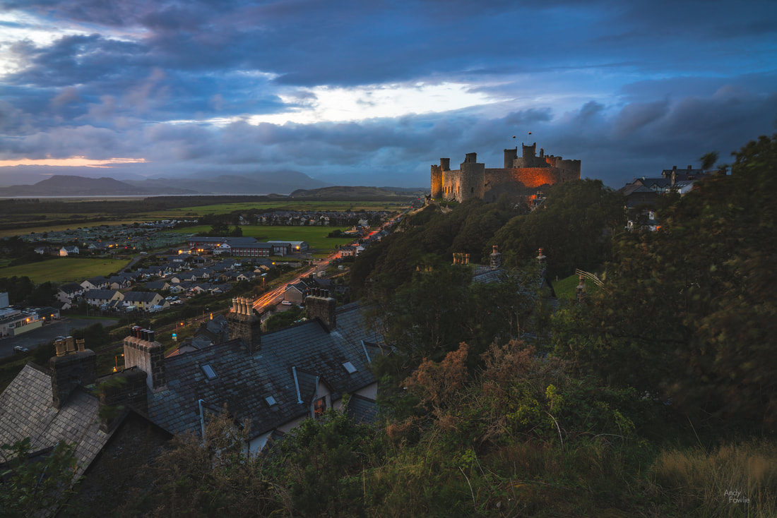 twilight at Harlech Well, that's it for this time, tune in again next week for the final chapter of my report from North Wales. Andy Recent Posts In early August this year I spent some time in North Wales, a magical area for landscape photography. The area contains some beautiful scenery that reminded me at times of the English lake district and at other times of the west coast of Scotland. As it was the height of summer my luggage contained both shorts and sunscreen, sensible and appropriate precautions, which turned out to be outrageously over-optimistic. On this trip, and indeed on every trip of 2019, I have been under a dark cloud (literally, not metaphorically) almost constantly. I have learned over time to embrace whatever atmospheric conditions I am given and tailor my photographic activities to the weather, there are things that work even better from a photography point of view in conditions which you could not describe as pleasant. When the rain pours down, as it surely did when I was in Llanberis, then the light conditions are often absolutely ideal for shooting waterfalls. 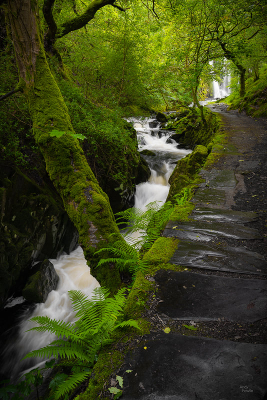 a forest cascade The highly diffused light which results from a blanket of cloud is ideal for this kind of scene whereas strong direct light would create very harsh highlights and overly deep shadows. The incessant rain helps to swell the flow of running water and gives an extra vivid quality to the green foliage, especially when a polarising filter is also taken into use. The patterns that water makes while descending a steep rock face can often make for an attractive and slightly more abstract "intimate landscape". 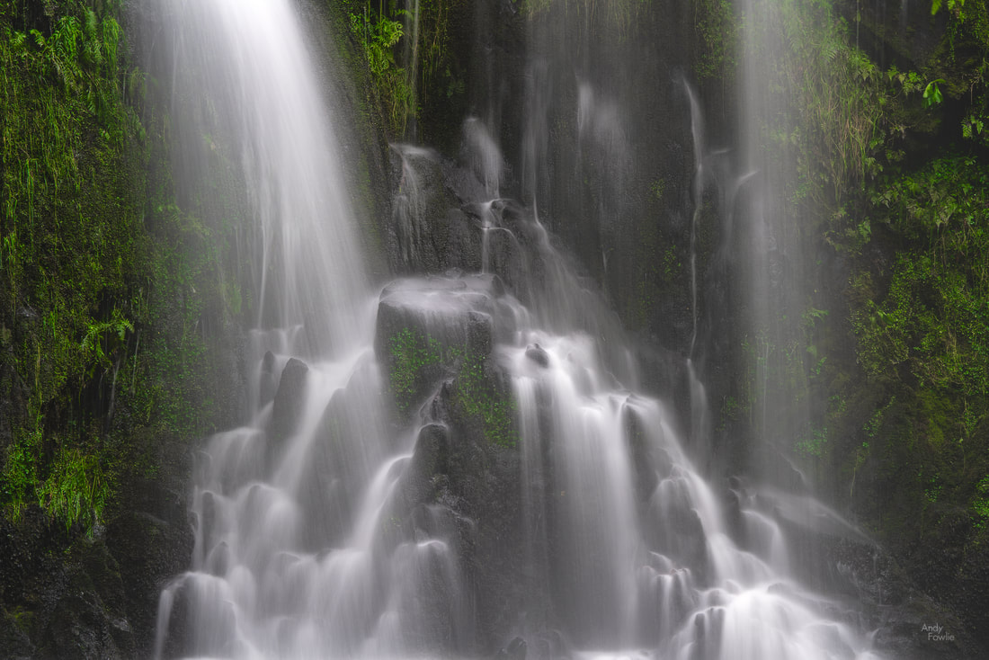 cascadia I sometimes notice people that seem to equate landscape photography exclusively with grand vistas and wide angle lenses. I do often shoot more expansive landscapes but I have found it helpful to employ many different focal lengths on my landscape photography trips, trying to be thoughtful about how best to capture the things that interest me in a scene. For instance, during this 10 day trip I employed 75 different focal lengths from 18mm to 400mm, a fairly typical statistic for me on such a trip. I have spent a lot of time in the UK this year (nearly 3 months in total), more than for any year since I moved to Finland 17 years ago, spending time in multiple areas of England, Scotland and Wales. I feel increasingly strongly that the remarkable past of these small islands is a defining factor in much of what is impressive, and also much of what is depressing, about modern Britain. The huge amount of surviving castles and strongholds which decorate the British countryside are reminders of very different times and a tribute to the people who have made the decisions needed to ensure that they are still (more or less) standing after many tens of generations.  the ruins of Dolbadarn Castle Before this trip I expected that the few days I had in Snowdonia would be my favourite part of the trip, the mountains in this area are not especially high (Wales has only 10 of the 350 highest peaks in the UK) but they are often quite steep and prominent compared to the surroundings which allows for some dramatic scenes. The relentless rain made me reconsider some of the (not very serious) climbs that I might otherwise have attempted, muddy and slippery conditions make quite a big impact on both the safety of a route and the effort needed to complete it... but luckily there was still much of interest a little closer to the ground.  Ogwyn Falls The various lakes in Snowdonia would have made for ideal photographic subjects in different conditions, but the high winds were killing all chances of reflections, just as they were for the entirety of my visit to the Lake District earlier in the year. 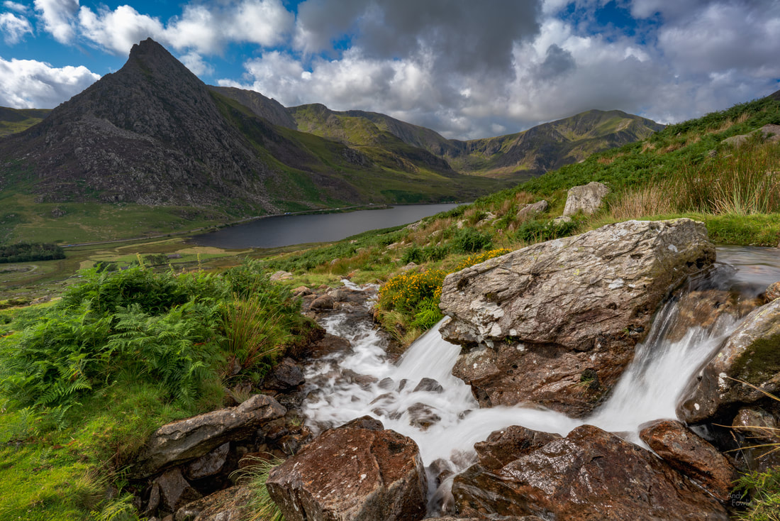 the tiny river of Afon Lloer with the peak of Tryfan dominating the far side of the valley One of my days in Snowdonia did at least offer interestingly mixed weather during the day, with clouds racing dramatically across the sky, something I later realised would have lent itself rather well to timelapse photography. Despite the generally grumpy weather the area was very well populated with hikers, tourists and the occasional other photographer, many car parks were full at locations across Snowdonia, but the vast open spaces seemed to manage to swallow the visiting hordes quite effectively and it was possible to find relative solitude by following the second or third most popular trail at a given location. 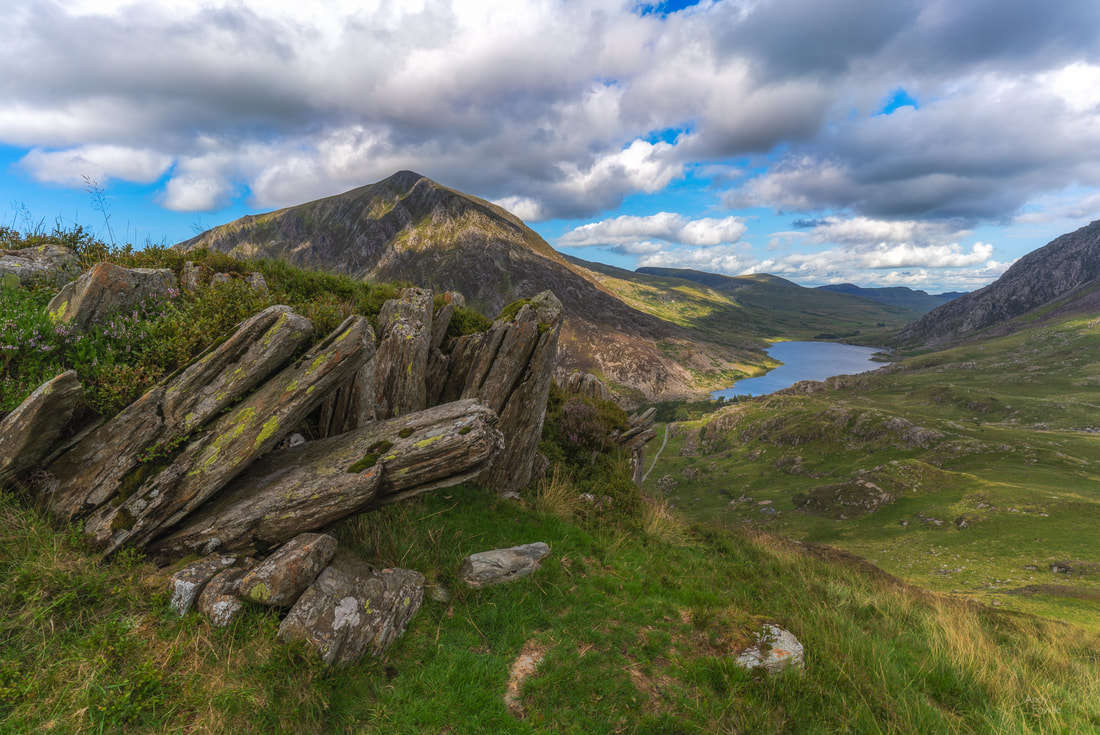 Pinnacle Crag The following day the downpour resumed and I found myself seeking out waterfalls once again. I travelled to my third "Fairy Glen" of the year ( after the famous one on the Isle of Skye and the not so famous one in Rosemarkie). At this location, I was completely alone and plucked up the courage to record footage for an instructional video with my thoughts about how to shoot such a scene... after recording multiple videos over the course of 45-60 minutes I realised that I really didn't much like the composition I had selected and was therefore making a "how to make make a bad picture" tutorial. Although that tutorial will likely never see the light of day I will try such things again in future in an attempt to get more comfortable on the other side of the camera as I think such content could be of use and interest at least to some of my photographer friends and maybe eventually to a wider audience. It is a challenge for a photographer to build an audience and I think that video content might be a way to expand my reach a little if it is done well. I continued to another waterfall nearby, the very touristy Swallow Falls, two miles west of Betws-y-Coed. 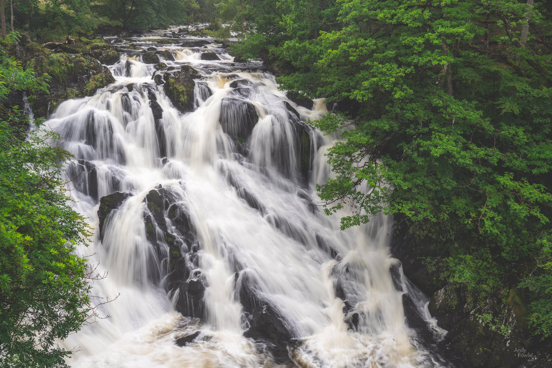 the classic view of Swallow Falls As is often the case with tourist attraction locations such as this you are funneled (through a turnstile where they relieved you of a couple of pounds in this case) to a certain set of viewpoints and don't have a lot of choice about your shooting positions. Crowds of people also makes it a little harder to set up a tripod. Such places are often not ideal for landscape photography but if, like me, you also really enjoy seeing new places it is inevitable that you find yourself in such an environment now and then. In this situation I usually try to capture the classic shot you are directed towards (such as the one above) and then look for something which can be more my own. It is always possible to find something that has not been done millions of times before, but it is not always possible to find something which is any good. Looking at the scene above I thought that there would be a possibility to use a longer lens and capture a more intimate scene featuring just the overhanging branches on the far bank of the river and the cascading water of the falls. 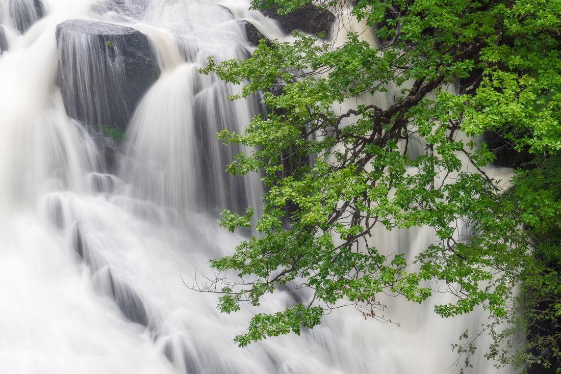 my version of Swallow Falls For anyone that finds themselves in this location, the Swallow Falls Hotel across the road from the waterfall entrance provides a cosy place to shelter from the elements and hearty pub meals to restore your energies. 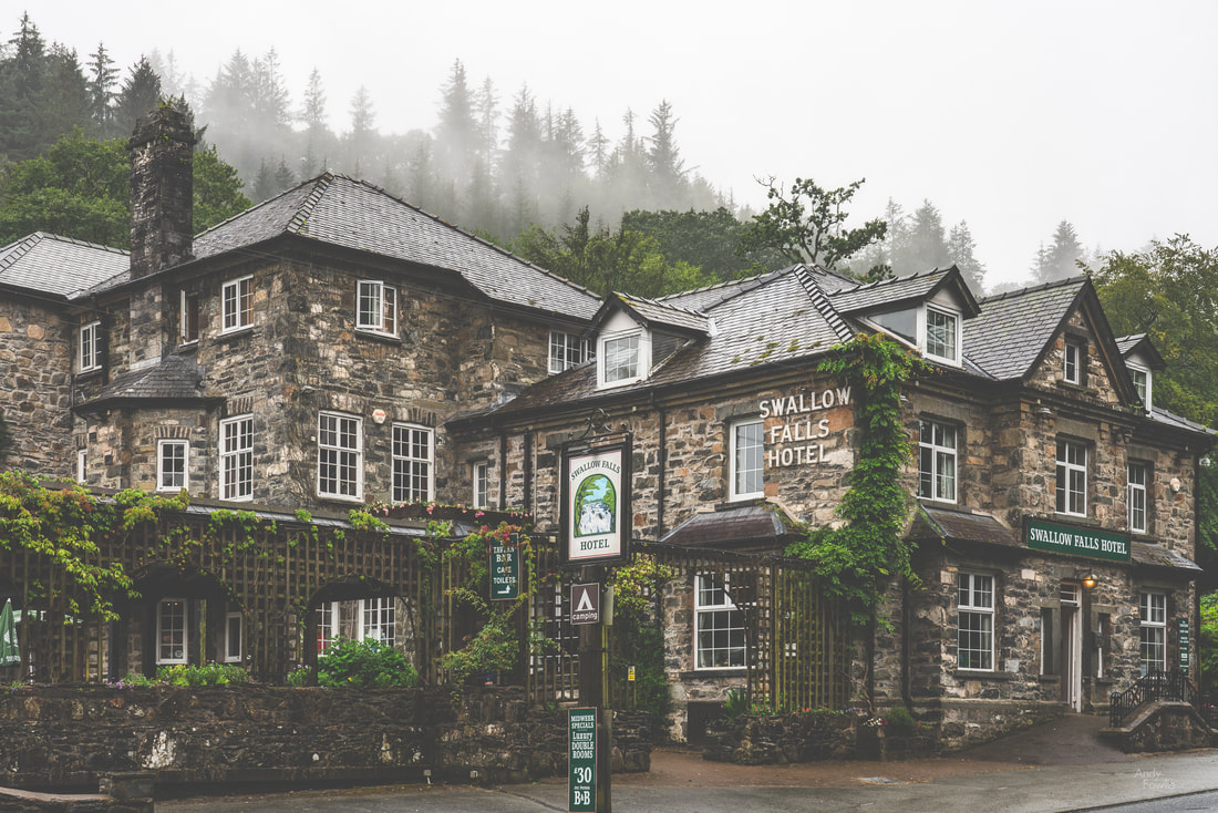 Swallow Falls Hotel - I recommend the Scampi and Chips. One common feature between this area and England's Lake District is the prevalence of slate mining as an activity. I took the opportunity to spend my final morning in Snowdonia visiting the site of the huge Dinorwic slate mine which is no longer active but at it's peak was the second largest slate mine in Wales and also in the entire world. This sprawling site has numerous paths running through it and affords views across the valley to the peaks on the other side as well as views long the valley itself. 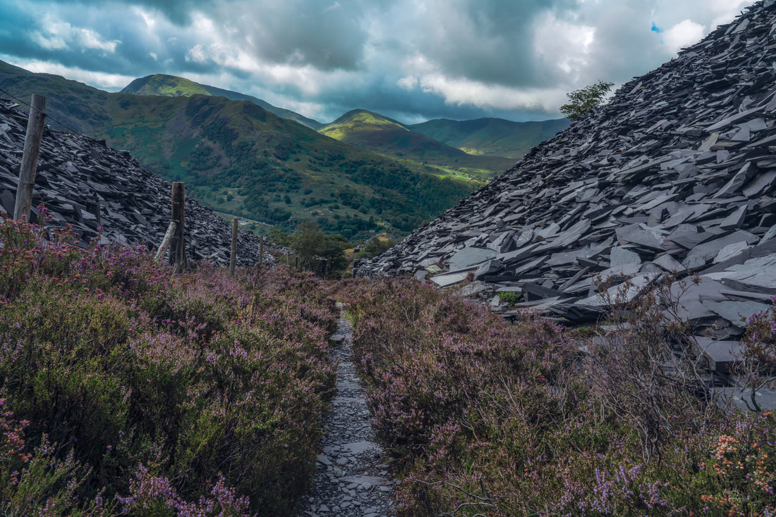 a path between huge mounds of discarded slate fragments leads the eye towards the hills on the opposite side of the valley On this day the cloud cover percentage was reduced to only about 90% which is actually pretty ideal for daytime landscapes as there is the attractive possibility of the sun bursting through now and again and selectively illuminating the otherwise gloomy scene. 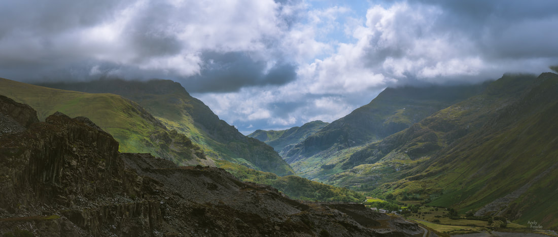 a panoramic valley view towards Pen-y-Pass This morning also happened to be the first day of the 2nd Ashes test between England and Australia so I was able to tune in, by phone or by car radio, to the familiar sounds of Test Match Special for eight hours a day for the following five days. The game of cricket, in all it's forms, but especially as a five day test match, lends itself like no other to the science and art of commentary, it is a sport which can be seen in vivid colour without needing to see any visuals. There are a number of reasons for this which are described below... for any heathens that do not already love cricket and are not prepared to be persuaded, I recommend skipping that part. Back to the slate mine, where some of my fellow humans have seen fit to leave their mark for others to see, the result is an image full of detail and texture. 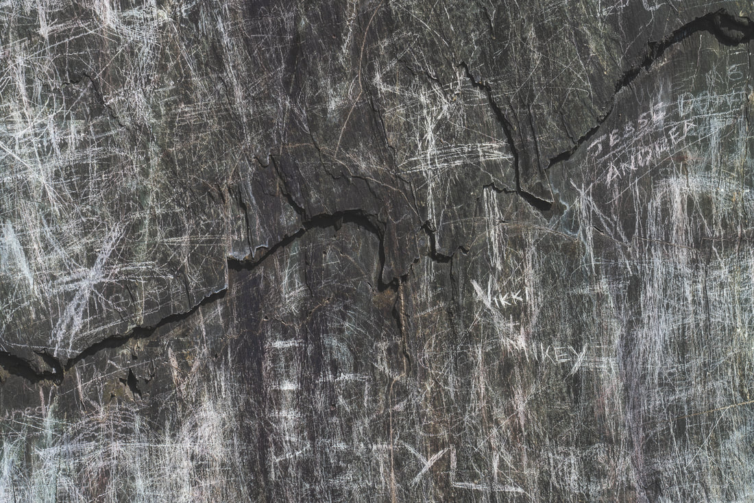 not a clean slate Well, I think that i will leave it there for this time, please join me next time as i continue to explore beautiful North Wales! Andy APPENDIX - Why cricket commentary is the highest form of the announcing arts The first key factor in elevating cricket commentary to the peak of the announcing arts is the perfectly detailed set of definitions. The vocabulary describing field positions is one aspect of this, it is truly wonderful how concisely the positions of the 15 persons on the field (bowler wicketkeeper, 9 other fielders, two umpires, two batsmen) can be described at any time, these definitions work equally well as a reference at all the different cricket grounds in the world and in all possible permutations. Similarly all the bowling styles, behaviours of the ball, batting strokes and outcomes of a ball bowled can be described with perfect clarity (to anyone who also knows the definitions) due to a beautifully complete, but versatile and flexible, set of definitions. This is already remarkable, but may not be absolutely unique among sports. The second ingredient which plays a key role in elevating cricket commentary to greatness is the element of time. Cricket takes ages! In a world where everything flashes past at ever increasing speed and attention spans are measured in fractions of seconds (how many of you looked at each one of my pictures in this post for more than a second each?)... a single game of test cricket has the audacity to last for five whole days. Seven or eight hours a day for five days! This is already quite something, but after all that effort there is still (historically) a 30+% chance that no result will be reached and the game will end in a draw. During these 40-odd hours of play (including breaks) the actual activity happens in short moments, a second or two of action about 90 times per hour, with frequent and extended periods where the drama, meaning and excitement (yes, excitement!) is to be found in the relentless overall trajectory of the play and the narratives that are woven around the teams and players rather then any particular ball bowled having an individual meaning. Cricket commentators might expect, in the best case, to spend noticeably less than 1% of the time explaining what is happening on the field and more than 99% of the time discussing other matters. Even these figures are over-optimistic, they assume that play will always be possible... but cricket is played ouside, often in England, and rain or wet conditions underfoot are fatal to the chances of play! It is quite possible for an 8 hour cricket commentary day to include not a single minute of actual cricket! The cricket commentary team must therefore collectively be a master of everything that might happen in the specific game itself, everything related to everything that might happen in the specific game itself, and also a host of other things, some of which may even be completely unrelated to cricket. They also have an unparalleled opportunity for exploration of a wide assortment of topics. The best of them, among which the BBC's test match special team can certainly be considered, manage to excel in this seemingly impossible task with ease and in style, keeping the listener interested from start to finish, again and again. The pinnacle of achievement among cricket commentary must surely have come last winter when the BBC did not manage to secure the rights to describe the actual cricket part of the cricket. So "the cricket social" was born. In this format the cricket commentators simply skipped the menial task of describing the (1-2 seconds ninety times per hour) of actual cricket and the result was masterful, 100% pure, commentary. Wonderful stuff. Recent posts This may sound strange, but with one notable exception I did not find the lakes to be a particularly interesting part of the Lake District... but in fairness I can admit that "the Hills, Trees, Caves and Waterfalls District" would be a far less catchy title for this beautiful area. It may also be the case that visiting on a less windy week would significantly change my thoughts on this matter. My trip continued with another early morning wake-up and a drive around Derwent Water to Brandlehow Bay where I hoped to photograph one of the old jetties which are still in use as stops for the boats which carry passengers to different points around this large lake. The weather was quite attractive for a change on this morning but I was a bit disappointed to find that the old jetty was now a new jetty... the fresh clean flawless light coloured wood probably ushered in a new level of comfort and stability but until a few seasons have taken their toll it has been robbed of some of it's character.  a new jetty My next destination was Rydal Water in the village of Rydal. This lake is another which has good paths allowing you to walk along it's length, either along the edge of the lake or slightly further back from the water allowing you to pass through some attractive woodland, I took the woodland path on an unusually beautiful (but stilll rather windy) day.  bluebells in the forest Another point of interest in the immediate area is Rydal Cave, another impressive cavern which is man-made in origin having been mined for slate many decades ago. Luckily this time there is no claustrophobic tunnel to travel through to reach it but there was a shallow water hazard to negotiate in order to get to what I considered to be the best shooting position.  in the jaws of Rydal cave After walking for a while at Rydal water I decided it was time for some more hill walking. The weather forecast looked semi-reasonable so I drove the winding road up the Honister Pass to the Honister Slate Mine where I parked my rental car and set off to climb up to Warnscale Bothy, a tiny old hut with clear views down the valley to Buttermere below. I told myself that the darkening clouds and hints of rain were not going to be anything to worry about and also told myself that the place would be easy enough to find based on the simplistic map I had in my guide book. The walk to the bothy is not very long, about 2.5 kilometres, but the elevation change is quite significant for such a short journey, first you need to gain about 300m as you climb up the shoulder of Fleetwith Pike and then descend 200m town the other side to the bothy. This route is not however provided with idiot-proof signposts and after completing the required ascent (plus some extra that I later realised was not required) I soon found out that my guide book was not sufficient to navigate to my destination while the offline maps in my phone (no signal here) were not sufficiently detailed to be much help... of course the rain was also falling and the clouds were darkening further. A perfect moment to remind yourself that you may not be a genius.  another judgemental ovine observer Although I was not 100% sure how to get to the bothy it would have been very simple to follow the trail back to the car so this was a frustration rather than any kind of threat of being lost in the hills. I continued in a direction which seemed plausible and was relieved to see a hut a few hundred metres ahead of me as the rain further intensified. As I got closer to the hut it was pretty obvious that although this was a hut, it was not the hut I was looking for, there were no magnificant views down to Buttermere. I decided that it would have to do and took some photographs before retreating down the mountain for some coffee and a bacon roll... much needed if not particularly deserved.  an English summer at Dubs Hut As the storm set in for the evening it was pretty clear that sunset was cancelled so I called it a day and thought I could catch up on some sleep. The forecast was promising that the storm would disappear about an hour before sunrise the next morning so I planned a dawn mission to Buttermere. My alarm went off at 0300 and I was on the road by 0310. I was not expecting heavy traffic so I decided to take a very narrow road through farms and a hill pass to shave a few minutes off my journey and be there in plenty time for whatever spectacular sunrise might await me once the storm stopped. This was good thinking and I was in position at Buttermere well before 0400... but the weather was not following the weather forecast. There was absolutely no sign of the rain stopping so I decided to take a walk around the lake for scouting purposes. I completed the circuit in about 2 hours, including a detour caused by a bridge being out, and got a strong feeling that Buttermere was going to be my favourite of the lakes in the Lake District if only I could get some half decent conditions. I headed back to Netherdene Country B&B for breakfast. Another strong feature of the Lake District is the pay and display car parks, there are many of them, very many of them. Most of the car parks at popular natural attractions are owned by the National Trust, some by local authorities, some private... but one way or another you are going to do a lot of paying and a lot of displaying. If you are a paid up member of the National Trust then you can park in all their car parks for free but as a short-term visitor from another country an annual National Trust membership does not make much sense. The way the payment terms work out (e.g. £5 for up to 2 hours, £7.50 for a day) is quite reasonable if you stay in one place for the whole day, but if you want to visit many places per day then it gets very expensive... so after breakfast I returned to Buttermere to use up some remaining parking hours from my failed dawn mission.  A moody view from Buttermere with Fleetwith Pike on the left and Haystacks on the right... Warnscale Bothy is allegedly located high up in the valley between these peaks. The weather was still unpleasant and not very photogenic but by now I at least started to know what I would want to shoot at Buttermere if I got a proper chance... and I had walked 20 kilometres by the time I had lunch. I continued my journey, deciding to visit Blea Tarn, another potentially lovely little lake near to Little Langdale. First I had to endure a 25-30 minute detour along a horrendous hill road (due to the navigation system in my rental car having some "special ideas" about where the Blea Tarn car park was located) but eventually i got there and paid yet another £5 parking fee. The wind was once again too strong, even in this more sheltered destination, and all thoughts of reflections were removed from the equation, which removed all interest from shooting the tarn itself. The views over the Langdale Pikes were still spectacular however. 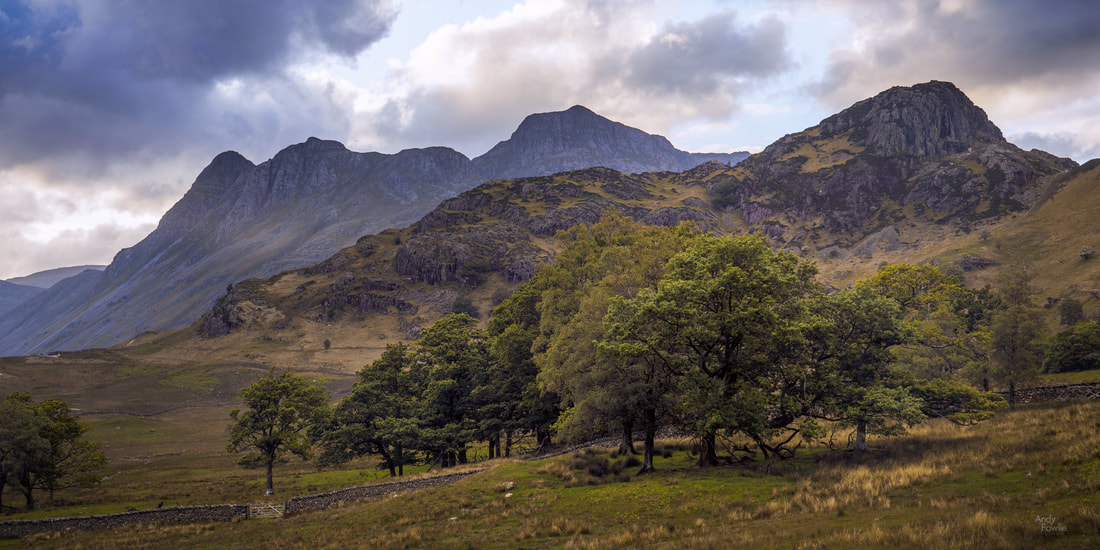 a panoramic view towards the Langdale Pikes Well, that was one of those days, a lot of effort for no reward. It wasn't the first and it won't be the last. The next day it was rainy again. Instead of imagining for the third consecutive day that the weather would bend to my will I decided to tailor my activities to the conditions (a much more sensible appraoch) and seek out some waterfalls. Overcast conditions are ideal for waterfall shooting. I drove to Ambleside and walked up the hill to Stockghyll Force, a lovely waterfall in leafy green forest. 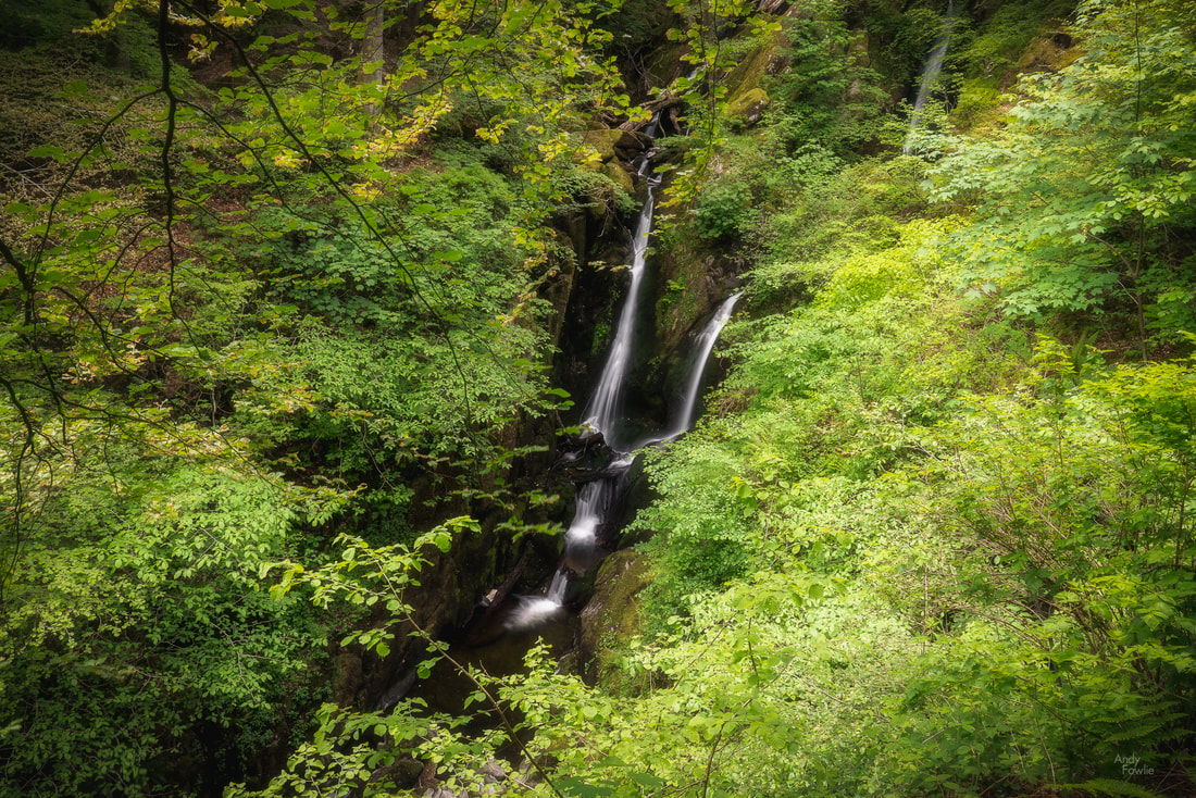 Stockghyll Force From here I took a bit of a longer drive to Wasdale Head from where a few other waterfalls can be found. 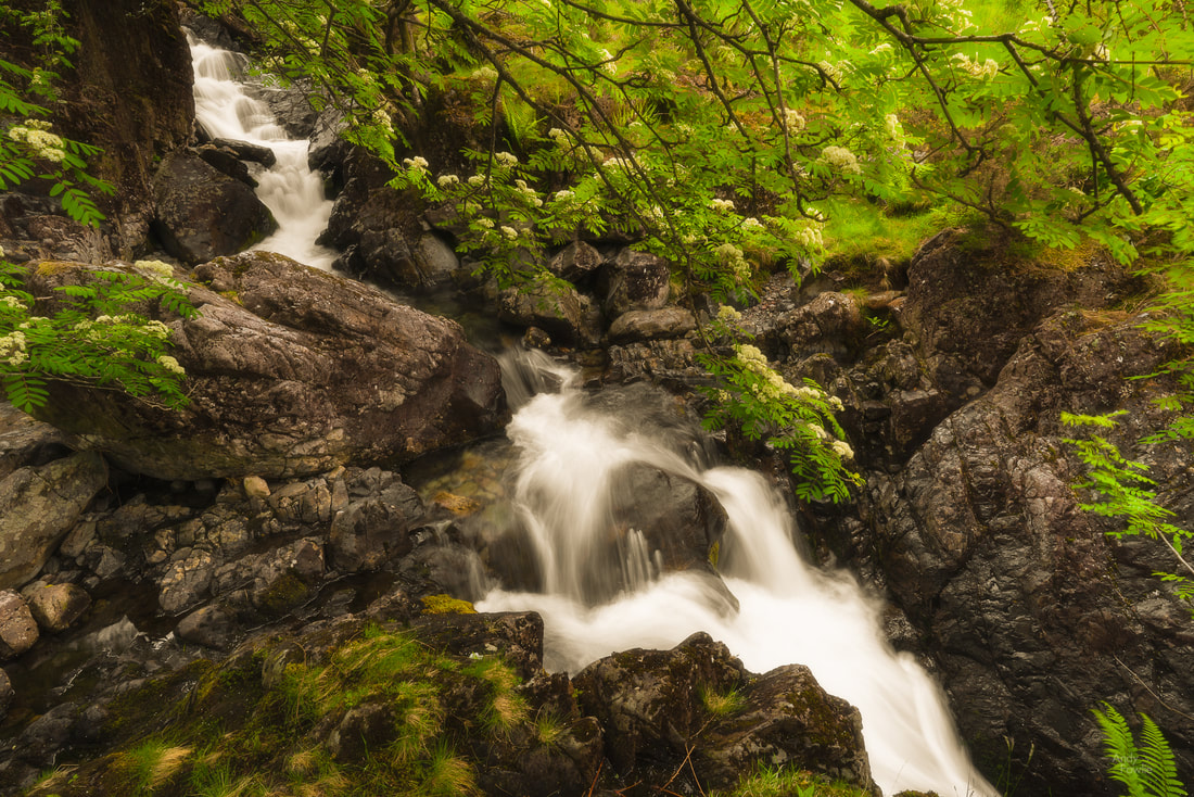 Ritson's Force As the rain continued to fall I decided to climb part of the way up Kirk Fell to get a good view over the sheep fields down below... I suppose that if I had a drone I could have got the same shot with a great deal less effort.  sheep fields and St Olaf's church at Wasdale Head Ritson's bar in the Wasdale Head Inn provided an excellent hot meal for me after I returned to ground level and I reflected on how much better my results had been when I was taking my lead from the weather rather than fighting against it. Hopefully I can put that learned lesson to good use from now on. Until next time, Andy Having spent my time over the past couple of years exploring the rest of Europe I started to realise that I had not really seen much of what my country of origin (the UK) has to offer. I have seen quite a few Scottish highlights but things that lie south of the border were more of a mystery to me. As spring started to think of giving way to summer I headed for the beautiful Lake District in the north west of England. I took advantage of the convenient direct flight with Finnair from Helsinki to Edinburgh and made the 3 and a half hour drive south to the Lake District, starting my trip by exploring the sights around Ullswater. 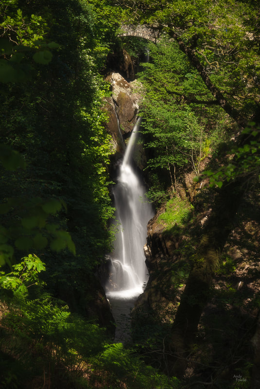 Aira Force waterfall Before my visit began I imagined that I would be spending a good deal of time shooting lake reflections and waterfalls, but in practice both of these things were slightly limited by the prevailing weather conditions. My visit coincided with a period of quite heavy wind causing choppy water surfaces which spoiled almost all hopes of shooting reflections on any large body of water. The weeks preceeding my trip were also unusually dry, reducing many of the beautiful waterfalls to an unimpressive trickle. This was to be one of those trips where the weather was not on my side.  the stream dribbles slowly under Ashness Bridge
One slight hardship when travelling in late May is that sunrise starts to be at a very inhospitable hour. With the sun due to rise at about 0430 I tried to be in place at my sunrise destinations by about 0345 each day... on this trip I seldom got any reward for this, but it is a good habit to get into. I have never found weather forecasts to be a great predictor of whether the weather will look interesting or not so unless it is 100% horrendous I usually try to be in position in case something good might happen. This first morning was one of the best ones of the whole trip and the sky was filled with a multitude of small clouds in the hours following sunrise. There was some wind but not so much that all reflections were completely ruined, allowing for at least a partial mirror effect in longer exposure photography. 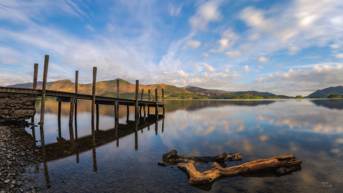 "Cloudy with a chance of Meatballs" - a lovely morning at Ashness Jetty The outcome of the sunrise photography session has a noticeable impact on the feeling of the day. With a decent image in the bank you can feel like anything else that you can take from the day puts you into profit, while a difficult morning can put extra pressure on the rest of the day. I have tried to persuade myself to just accept whatever I get and carry on but that does not always come easily. On my way back to the Great Wood car park I became interested in the flowers on the forest floor and stopped to capture another image before heading back for a well deserved breakfast.  the forest floor One feature which will rapidly become apparent to Lake District visitors is the network of very narrow roads with tall leafy hedges at either side. When this is combined with large numbers of visitors you very quickly get to the situation where nobody is able to go anywhere in any sort of hurry. A morning drive to beautiful Tarn Hows was a prime example of this, crawling along the roads on a journey which seemed to take for ever. A tarn (not a word I had encountered before) is a mountain lake which forms in a hollow left behind by a retreating glacier and there are a few tarns dotted around the Lake District. Tarn Hows is a particularly beautiful example, surrounded by small hills and offering wider views towards the Helvellyn range and the Langdale Pikes. The Tarn has a level and accessable path which follows the lake shore in a 2.5km circuit, making for a very pleasant walk. 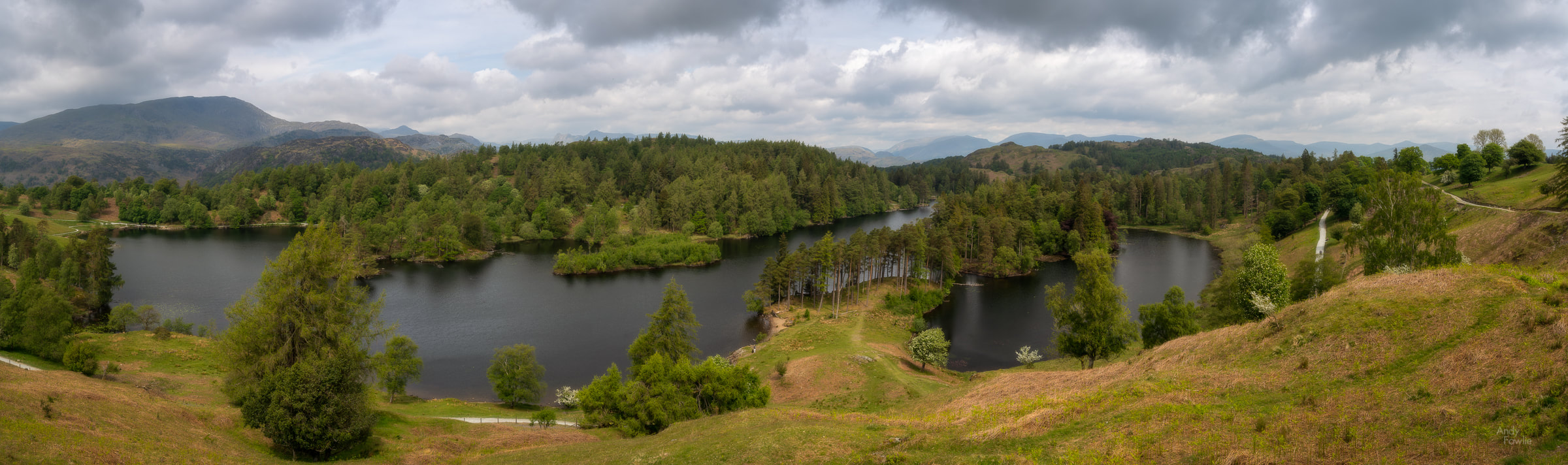 A panoramic view over Tarn Hows One of the thing that I was struck by during my first days in the Lake District was the beautiful old trees which were in full leaf all over the area. Trying to photograph these is always an attractive idea but it can be rather hard to find good compositions, especially if there are other trees in the vicinity.  a study in brown and green  battered but not broken Exploring a sequence of rapids near to the tarn revealed the extend of the drought... but "luckily" there would be a horrendous amount of rainfall in the coming days to restore some normality. Unfortunately while I was able to witness this cure being administered I was no longer around to see the results.  "buffering?" - this stream was not doing much streaming Despite some slight disappointment with the weather and the light I very much enjoyed visiting Tarn Hows and I hope I can return one day, it seems like it would be at it's absolute best with autumn colours so maybe I will try and make my second Lake District trip at that time of year.  a moody view across the mountains from Tarn Hows After my morning at Tarn Hows I headed for the town of Coniston where I had a quick lunch before embarking on a climb towards Levers Water, a high mountain lake above the village. The guide book i had with me said that it was a fairly easy round trip of about an hour to get to and from the lake... which turned out to be highly optimistic. After climbing steadily for nearly an hour on a pretty warm afternoon I reached a sign telling that it was only another mile, a mile which coincided with the path becoming significantly steeper. Eventually, I made it to the lake... where I took precisely zero pictures as the wind made the surface of the lake completely useless for reflections and I did not see any other interesting compositions. It is always the case on any trip that some locations just don't offer what you hoped for in the conditions of the day. 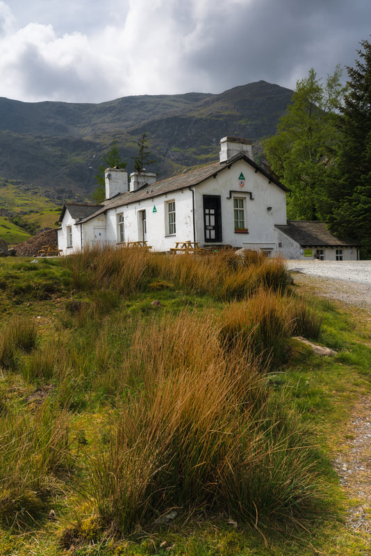 The Coniston Coppermines youth hostel, on the way to Levers water The walk down again, gravity assisted, was somewhat easier but I was pretty sure that the sheep roaming the hillside were giving me judgemental looks as I went past. 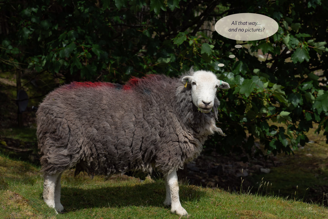 eat your grass and leave me alone.... According to my fitbit the walk from Coniston to Levers water and back had taken over 12000 steps... but I was not done for the day. I drove to Lake Windermere and had a look around that area.  a rather curious 2D tree With dull and lifeless skies, branches blowing in the wind and disrupted water surfaces it was necessary to find alternative things to point my camera at if I was going to rescue the day. 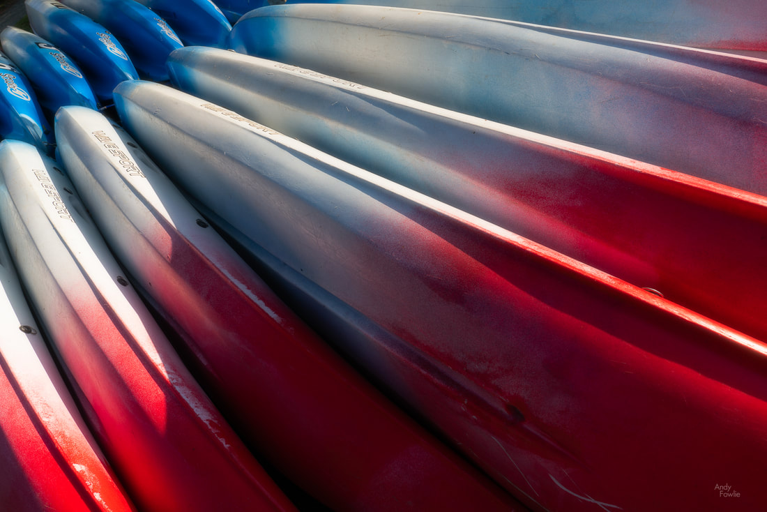 "banana boats" - the form of these stacked canoes reminded me of a bunch of bananas My final stop on this long and tough day was the lovely stone bridge at Clappersgate. This was my sunset destination and I was treated to slightly better conditions as the sun actually came out for a little while and the well-sheltered, slow-moving river was somewhat calm... it did cross my mind that I could easily have stayed in bed until sunset time without missing too many great photography opportunities, but it is always a lot of fun for me to explore new places even if they don't lead to great photos. 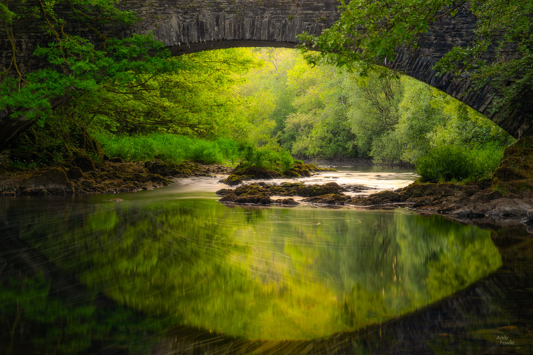 the Clappersgate eye The following day, after observing a miserable and colourless sunrise at Derwent water (the dark grey became medium-light grey), I made my way to the charming, tiny and slightly in-accessable village of Little Langdale. From there it is a short walk to Slater Bridge, an ancient stone bridge over a small river, connecting the village to an area used for quarrying on the other side of the water. The bridge itself was an interesting subject, but I was a bit put off by the metal poles and wires which are attached to it nowadays and also by the metal fences which are in place to keep you from parts of the surrounding area. Not everyone was respecting these barriers but I felt that I should, which limited my possibilities for shooting.  the Slater Bridge, wires and all Having crossed the famous old bridge I continued onwards to the old quarrying area, suppressing my discomfort as I ventured through a narrow tunnel into Cathedral Cave, a large chamber with a hole in the roof which lets the daylight stream in. 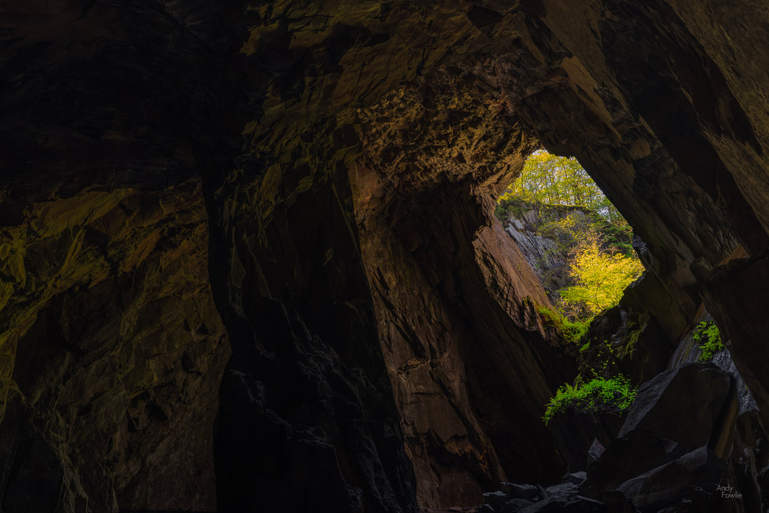 a light in dark places - Cathedral cave For sunset on this day I walked to Friar's Crag, a viewpoint over Derwent water which was described by 19th century writer and art critic John Ruskin as offering one of the finest views in Europe. With all due respect to Mr. Ruskin... I somehow doubt he would have been similarly moved on this particular evening. While the view itself (not helped by the deeply unattractive light which was on offer despite the sunset hour) left me rather cold, I found something more interesting at my feet, a single red rose which had been discarded and trodden into the dust. This hinted at a million possible stories of rejection and heartbreak (and a few million less interesting tales), perhaps a earnest proposal of marriage or a devoted declaration of true love had been rejected in a cruel manner, crushing someones dreams for eternity. Whatever the unknowable story, I deemed this to be a more interesting subject than the famous view in front of me. 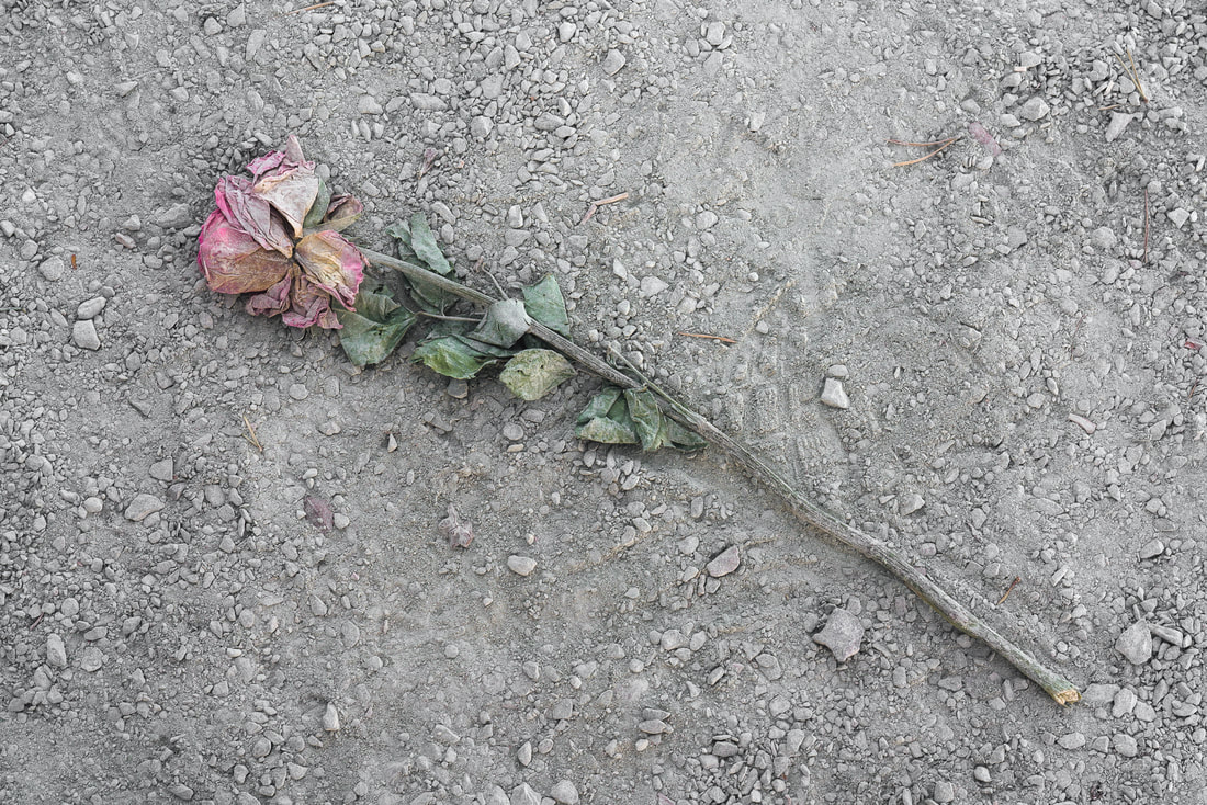 requiem for a dream In the hope of avoiding reader fatigue I think I will sign off for this post and return to the lake district once again in my next blog. Thanks to everyone who reads this, I hope that you have enjoyed this post. Please feel free to comment in the comments section below or via my Andy Fowlie Photography facebook page. Until next time, Andy As my Scotland trip neared it's conclusion I decided that I wanted to spend those final days back on the beautiful Isle of Skye. On my way I decided to visit Eilean Donan castle, a 13th century stronghold which was destroyed in 1719 after a failed Jacobite uprising. An early 20th century restoration project brought the castle back to it's former glory and it has operated as a tourist attraction since 1955. I approached the castle as the sun was going down and the waited for the time when the declining brightness of the sky matched the brightness of the artificial lighting on the castle, allowing for an even exposure. I used a 6 minute exposure to give the sky a more dreamy appearance. 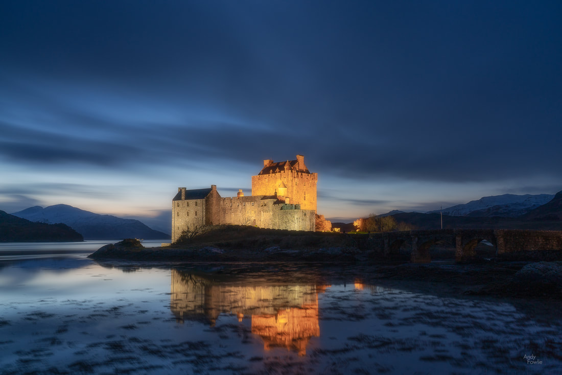 Eilean Donan castle Accomodation was not that easy to find on Skye at very short notice during the off season, which gave me a good excuse to stay at the excellent Cuillin Hills hotel even though it was (deservedly) a bit more expensive than I would have normally wanted. The location of the hotel on the north-east of Portree was a good fit for my purpose as I wanted to focus on shooting the Trotternish peninsula on these few final days. The Trotternish peninsula is the northernmost part of Skye and it's unique features were sculpted by massive landslides (the largest known to have happened in the UK) which occurred after the last ice age. As you leave Portree and head along the coast of the peninsula one of the first attractions that you come to is the Bride's Veil waterfall, a small series of hillside cascades which offer a view with the Old Man of Storr in the background provided you are willing to jump across the stream. 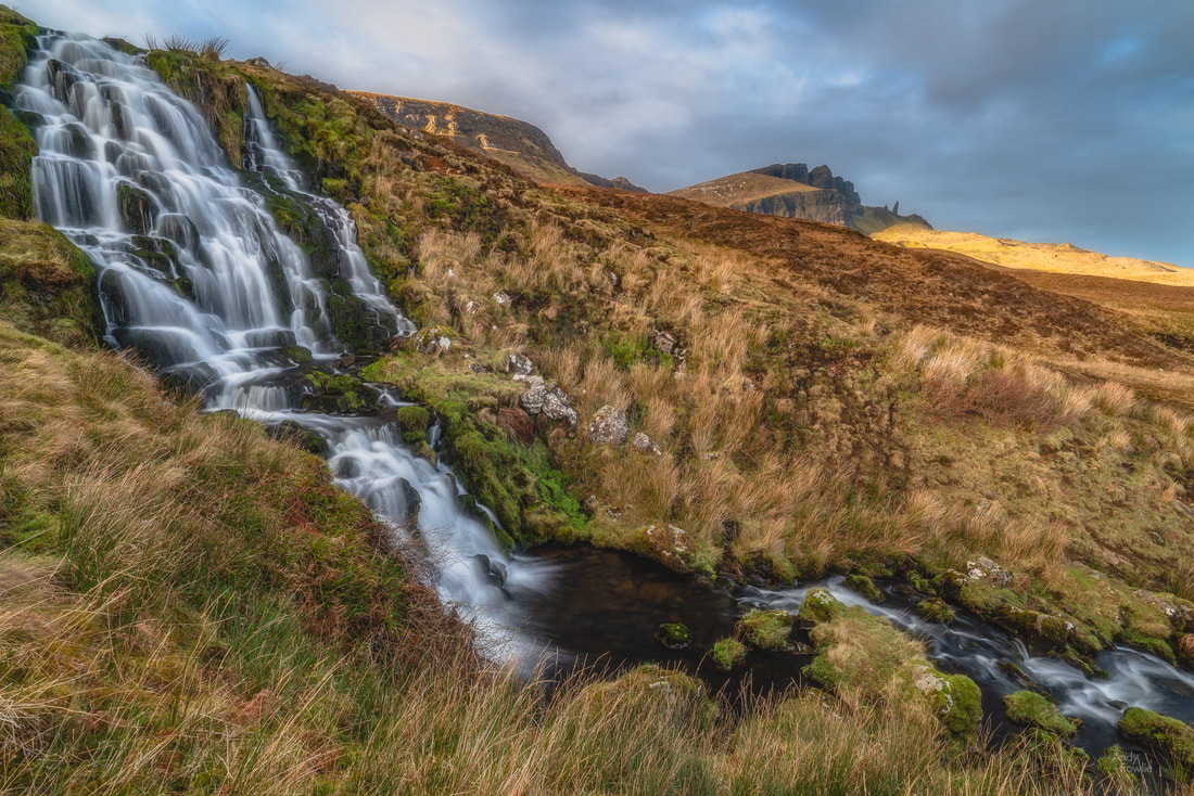 Bride's Veil Falls with the Old Man of Storr visible on the horizon Continuing the journey you come to the beautiful Loch Fada with it's single lonely island. 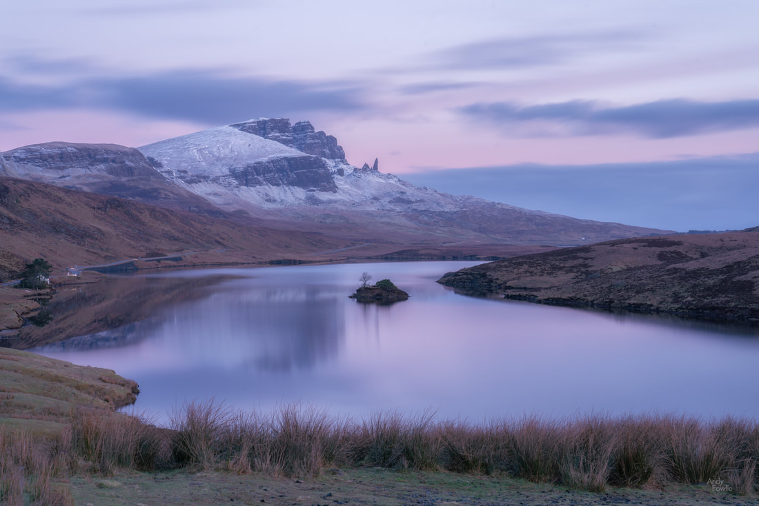 Loch Fada before dawn - a five minute exposure The Storr (the mountain in the left-centre of the picture above) is the highest point on the peninsula and the iconic rock pinnacle on its lower slopes is known as the Old Man of Storr. The Old Man is clearly visible as you approach Portree and is recognisable feature from many vantage points in the area. To the north of the Storr there is a vantage point where you can view Mealt Falls cascading down Kilt Rock. The vantage point is somewhat limited when it comes to photographic compositions, this is one spectacle which might be better viewed from the sea or the air. 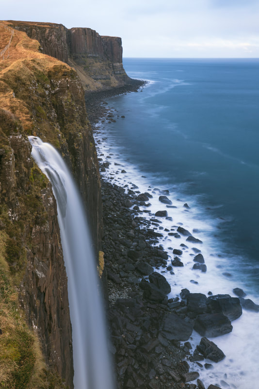 taking the plunge - Mealt Falls Before visiting Skye one of the places I was most looking forward to was the Quiraing, possibly the most dramatic of the areas sculpted by those ancient landslides. It is unfortunate that the weather turned instantly unpleasant on each occasion when I made the meandering ascent to this spectacular location. I still spent many hours walking here with my camera but when the light is really against you there is not always a huge amount you can do about it.  Trotternish formations - the Quiraing I hope, one day, to be at the Quiraing in some better light as it was a truly stunning place. On the opposite side of the Trotternish peninsula you can find a zone known as the Fairy Glen due to it's interesting but relatively small features, almost like a miniature Quiraing. My short visit to this place was a bit odd. Firstly I was a bit concerned about ending up trapped there - the narrow winding road passed over a cattle grid and there were signs saying that the cattle grid would be replaced, causing significant delays for traffic, and indicating that the work would happen on that day... this contributed a bit of a rush to proceedings as well as a "this could be a bad idea" feeling. One of the things I like most about being out in nature is the peace and quiet, but my visit to the Fairy Glen coincided with the visit of an extremely loud family and their similarly high volume canine companion. I could hear every word of their exchanges from at least 300 metres away and that added to my irritation. My time there was more based about maintaining maximum distance from the loud people than it was about photography, and the impact of that was obvious when looking at the images later. This is another place I should revisit in different circumstances, but I did at least have a bit of fun processing the images.  "An enormous toad" - a mirrored Fairy Glen landscape. During all my time on Skye I was very much hoping that at least one morning would give me suitable conditions to take best advantage of the 45 minute climb up to the Old Man of Storr. On one of the days, early in my trip and very early in the morning, I made my way towards the Storr, hoping that the cloudy twilight would give way to something interesting. An hour before sunrise, as I was approaching Loch Fada, there were some beautiful pastel colours in the clouds and heavy snow on even slightly higher ground.  an Old Man of Clouds hurries past the Old Man of Storr The climb up to the Old Man of Storr is not a particularly challenging one, but it is steep enough for long enough that you certainly notice that you are doing some exercise, the elevation gain is about 300m to the Old Man himself, perhaps closer to 400m to get to the higher vantage point that offers some of the best views. The climb starts from the car park and goes through an area where a non-native forest has recently been felled in order for indigenous vegetation to be re-established in it's place.  the path to the Storr The path makes it's way steadily upwards, sometimes over rather boggy ground and sometimes requiring more of a scramble over loose rocks. The sun rose as I was still climbing, but the most interesting light was still to come as the cloud and fog which were gathering over the area continued to act as a giant diffuser for the golden light of rising sun over the next hour or so, an effect which varied in intensity from minute to minute. 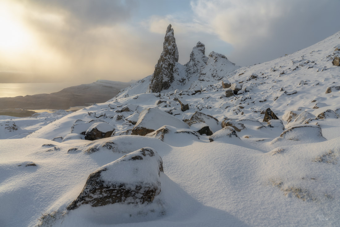 Across the snowy rocks to the Old Man The rocky pinnacle of the Old Man of Storr is 164 feet (50 metres) tall and stands proudly on the hillside. The area around it is surrounded by warning signs suggesting that one should not get too close due to the danger of rock falls. I usually pay attention to such signs but obviously not everyone takes the same approach. As I was loitering near such a sign a runner appeared around the base of the Old Man, coming towards me at a fair speed, dressed in shorts and a singlet (the temperature would soon be above zero after all), and rather irritated that some stupid photographer was standing on the narrow ledge which he had designated as his running track. He sprung off the path and proceeded through the boulder field without noticeably reducing his speed. In order to get the best vantage point it was necessary to continue the climb up to a high plateau, slightly above the Old Man. 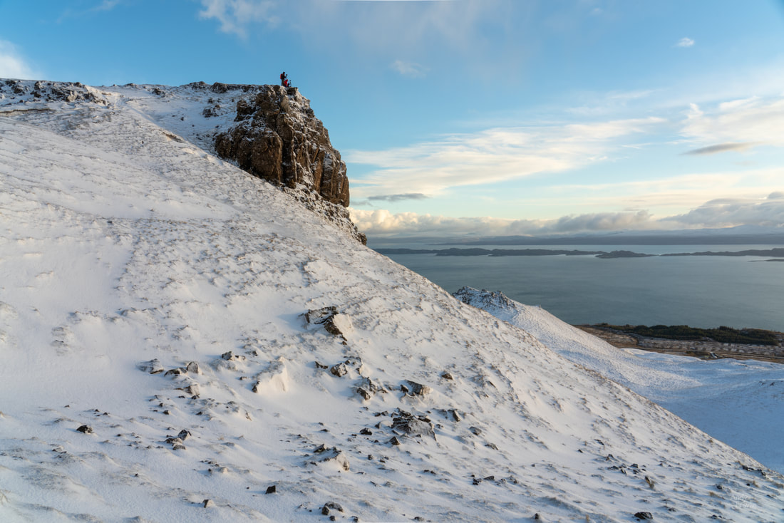 the high plateau While making my way up to the higher ground there was a short period where the cloud intensified and the light was at it's most stunning and I was able to get the kind of shots I had been hoping for. 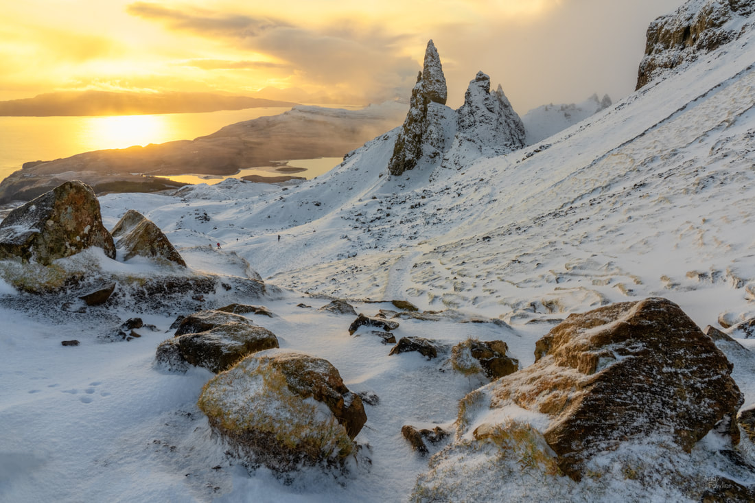 Morning light at the Old Man of Storr From the top of the plateau you can get a very good angle to see the individual rock towers, and the presence of other mortals helps to show the scale of the scene. 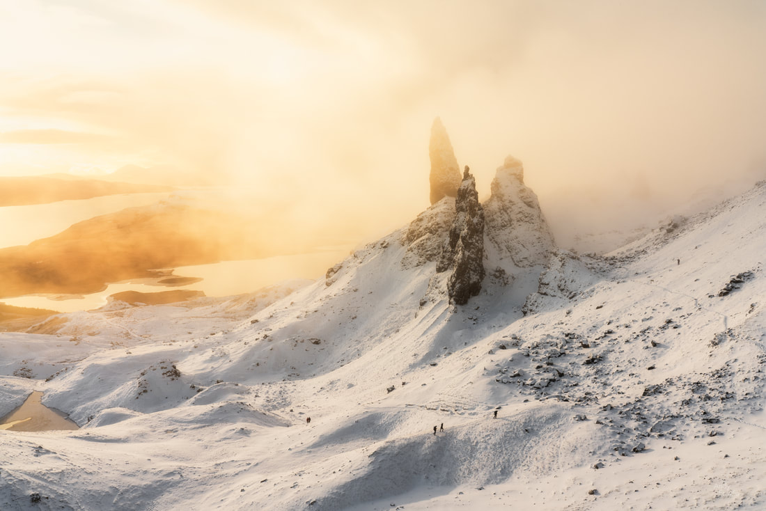 the magical Old Man of Storr As you move closer to the towering rocks you can get a bit of a different view, but it is probably wise not to get too close.  the rocky crown - on the path where I had earlier encountered the runner Despite the early hour, and the snow, and the fact that it was very much out of season, I was not alone on this beautiful morning. A number of other photographers and a few tourists were also able to witness this beautiful spectacle. A visit to the Old Man of Storr in the summer would mean that you share the experience with many hundreds of other people, assuming that you could find a place to park your car in the first place.  after the shoot - a fellow photographer makes his way back down the mountain Before bidding farewell to Skye I decided to make one more trip to the remote village and beach at Elgol. I always enjoy shooting at beaches and trying to make good seascapes, but it is also something that i am very much still learning.  Elgol on the rocks Some of you may have noticed that I keep finding excuses to use very long exposures in my photography. At Elgol, as the weather deteriorated towards a dreary sunset, I became interested in the slipway beside the beach and decided that a 250 second exposure woudl calm the waves and the clouds to give me a peaceful and minimalist view.  the slipway at Elgol My time in Skye was at an end and I had to start making my way back to Edinburgh airport to return to Finland. In a moment of nostalgia I decided to spend my last night on the other side of the country at the home of golf, the city of St. Andrews. I have played golf at St. Andrews dozens of times and visited on a few other occasions to observe professional tournaments, it is a place which is special to me, as it is to many other golfers across the world. At the same time my visit was tinged with a certain sadness as my back no longer lets me play golf on a reasonable level and I still feel that loss whenever I bump into reminders of my former hobby. 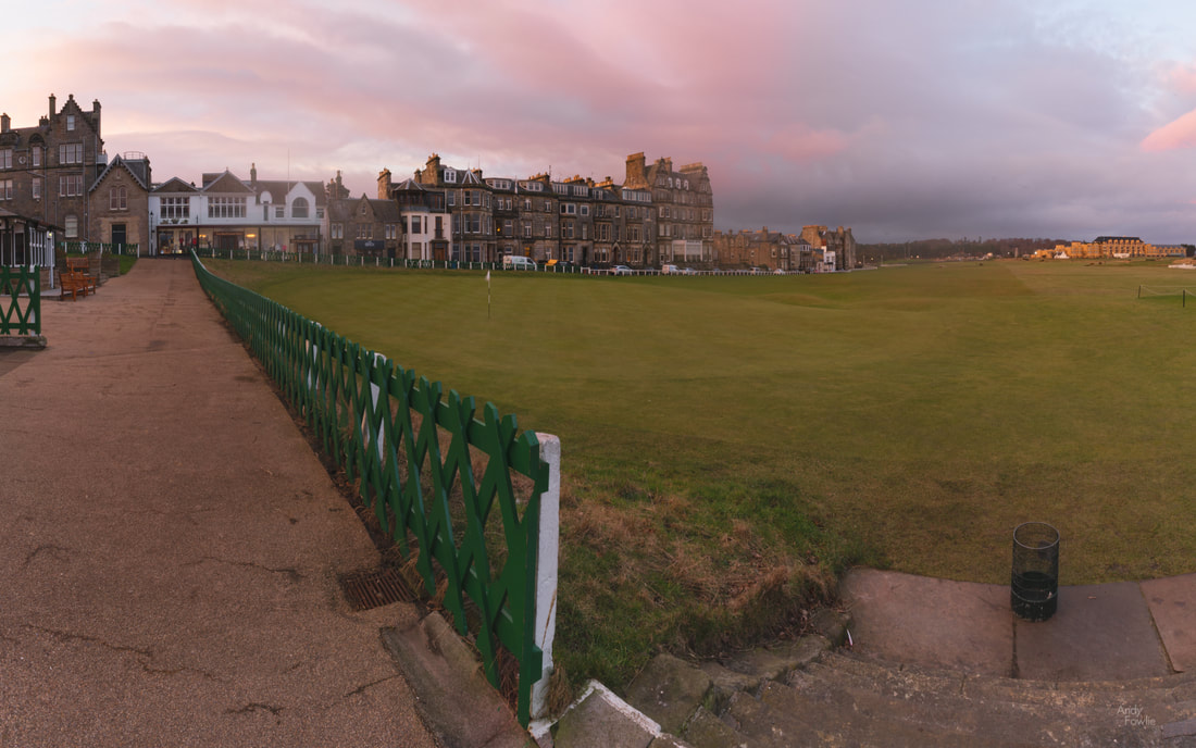 a pastel sunrise at the entrance to the Old Course, St. Andrews For the last hours before heading to the airport I left my cameras behind and took a long walk on the beach at St. Andrews, reflecting on the experiences I had enjoyed on what had been an excellent trip to my homeland. Thanks for reading. Until next time, Andy Water plays such a central role in your experience when visiting the beautiful country of Iceland. Surrounded on all sides by the Atlantic ocean, the 4970km of coastline provides amazing opportunities for interesting seascapes, while fans of freshwater can spend countless hours visiting over 10,000 waterfalls. Water also plays a key role in providing electricity through hydropower (~73%) and geothermal power (~27%). In this post I will share some water themed pictures from my autumn trip to Iceland. 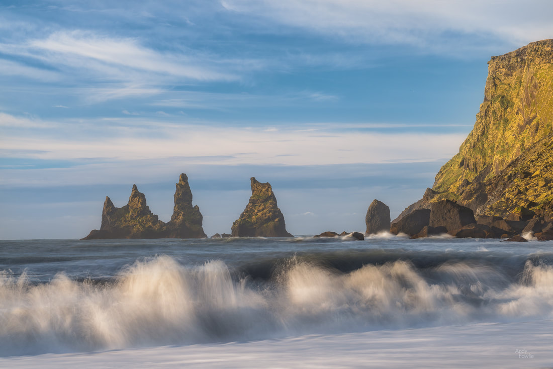 the motion of the waves is captured by a 1.3 second exposure Iceland's beaches are fascinating, beautiful, and in some cases very dangerous. It is wise to heed the warning signs in some popular places and to treat unfamiliar places with caution - never turn your back on the ocean. Volcanic basalt rock which makes up much of the exposed rock in the whole country, leading to the beaches with black sand instead of the golden or white sand beaches that are common on geologically older land masses. 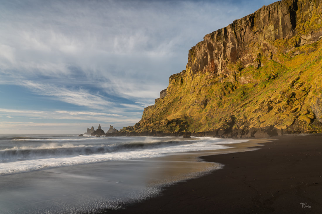 a beautiful day on the black sand beach at Vik Some of the spectacular Icelandic waterfalls have become huge tourist attractions, but with over 10,000 to choose from there are chances to get some of the less popular ones to yourself, at least for a few minutes.  one of the more hidden gems This trip took place in the middle of October and the autumn colours were strongly visible at that time, providing quite a beautiful colour palette at many locations. Iceland is generally not a land of trees and forests, but the abundant mosses and grasses cover the volcanic landscape with a blanket of yellows, oranges and reds at this time of year. 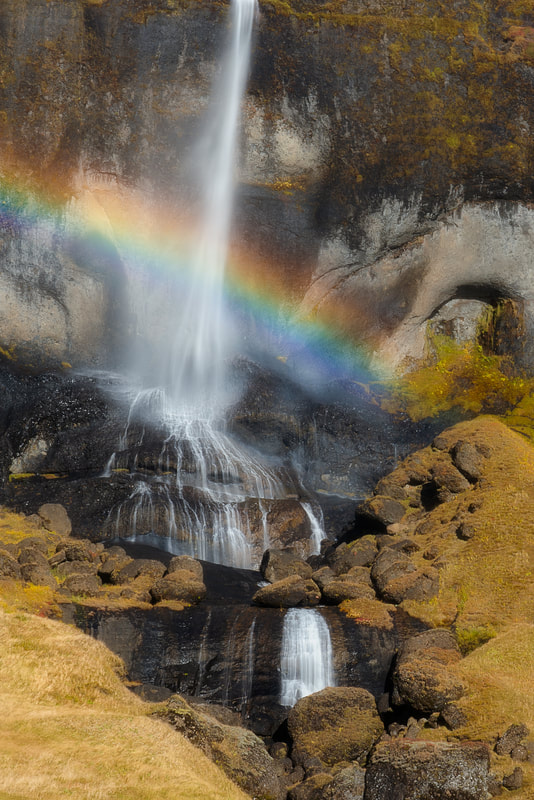 a waterfall rainbow On this trip I made a first (and probably last) visit to one of the more popular tourist destinations, the waterfall at Svartifoss. Searching for a parking space took quite a few minutes, it was very full despite the massive capacity (I guess maybe 1000 spaces), but I followed the trail upwards through some nice scenery to the waterfall, surrounded by hexagonal columns of basalt. The area around the waterfall had a population density similar to downtown Manhattan which made photography somewhat challenging, particularly because many people completely ignored the fences and signs informing you where you could and could not go. I set up my shot and waited quite some time for a break in the rule-breaking human traffic... a wait which included being asked to take phone pictures of some of the trespassers... and eventually managed to get a shot. It was great to see Svartifoss, but I will not rush to see it again.  autumn at Svartifoss On the walk up to Svartifoss there is a vantage point for another waterfall, Hundafoss. The crowds did not seem to be so interested in it, but I thought there were some nice colours in the bushes near the top of the waterfall.  autumn colours at Hundafoss Moving water can create great interest in landscape photography, but sometimes it is preferable to have things totally still - a smooth and calm body of water can work as a perfect mirror. With a wide-angle lens, low to the ground, you don't need much more than a puddle to get a full reflection of your scene.  Lómagnúpur I am always drawn to these reflection shots (I sometimes feel like I do too many of those) and usually manage to spot opportunities for them, perhaps trying to rely on that a bit less would make me pay more attention to getting interesting foregrounds for my pictures and give better results... something for me to think about in future. My journey continued round the southern coast of Iceland and when I passed through the tunnel just past the turn-off to Stokksnes (see previous post) I was into new territory, in previous trips I had not gone further around the coast than Vestrahorn. The coastal road (still highway 1, the road that goes right round the whole country) goes through quite beautiful scenery between Vestrahorn and its less well known twin - Eystrahorn. 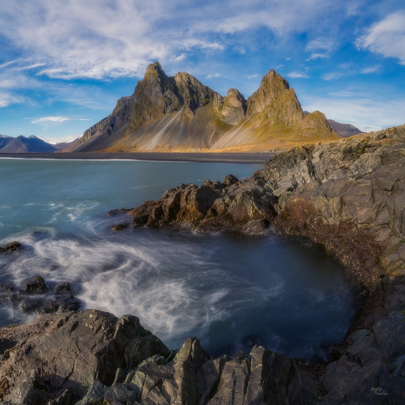 a tidal cauldron with Eystrahorn in the background Eystrahorn has a rather similar shape to Vestrahorn, the mountains are a little higher and maybe more dramatic, and there is a similar bay in front of the mountain backdrop. The bay cuts in from the left when facing the mountains whereas it cuts in from the right at Vestrahorn, so if you see a "Vestrahorn picture" where the ocean is on the wrong side then you probably actually saw an Eystrahorn picture.  waves crashing as we look west from Eystrahorn Continuing round the coast, moving north up the east side of the country, the waterfalls just keep on coming, one after another. I stopped at the side of the road to shoot this next one, it was very beautiful but as far as I can tell it does not have a name... in another country perhaps it would be more of a highlight.  Anonymousfoss? My Iceland trips have usually been arranged at quite short notice and that has led to a variety of different accomodations... not all of which I would be desperate to revisit. The east of the country starts to be remote enough to at least slightly reduce the amount of visitors and those who do venture there are probably doing the full circle around the country, so maybe this is an area which is more passed through than stayed in. I spent one night in the small town of Djúpivogur at the Hótel Framtíð, which proved to be a perfect place to stay with a good restaurant and very comfortable rooms. The price:quality ratio was much better than any of the other places I stayed on this trip and I definitely recommend it for anyone who visits this area. While having a morning cappucino in the reception area of Hótel Framtíð I was surprised to hear a familiar voice addressing a group of asian people that had been gathering nearby, it was Mads Peter Iversen. I have never met or spoken to Mads, but I have listened to many of his YouTube videos, he has a lot of great material about different locations, including practical information such as where to park and all the other things which it is hard to prepare for without seeing a location. I was interested to hear how he explained the coming day to his workshop group, and I thought I might say hello after he had finished his business, but he disappeared before I had an opportunity. Anyway... check out his channel, he is a good explainer and a great photographer also. Back to my waterfall hunt... I continued round the coast on a day where the weather slowly deteriorated.  Nykurhylsfoss My new "furthest point anti-clockwise around highway 1" came when I visited Folaldafoss... yet another waterfall, by which time the weather was a full-on snowstorm. Normally I don't like to have any people in my images but on this occasion I felt like it helped the picture to include the guy making a video call live from the scene.  It is always a little sad to be making my way slowly back towards the airport instead of heading out into the unknown, but in Iceland there is always something interesting to shoot.  snowy mountain reflections The interest is there no matter the time of day, as darkness falls the possibilities for stars and auroras arrive.  aurora reflections On the morning of my final day I decided to head for one of the most popular tourist destinations, the mighty Gullfoss waterfall. My idea was to try and beat the main traffic of the day by arriving well before any bus tours starting from Reykjavik could hope to be there. Gullfoss is a remarkable sight. The Hvítá river makes a sharp turn and falls down into a deep canyon with an average of over 100 cubic metres of water per second cascading over the falls.  looking back upstream towards the mighty falls in the early morning - the lonely figure on the rocks beside the first drop provides a sense of scale Following the path down to the rocky platform was a treacherous affair as the mist generated by the falls coats every surface in ice, there was advice to use crampons on this path and that was good advice. The view once you get closer to the drop into the canyon made quite an impression due to the enormous power of the water.  into the abyss As much as I like trying to capture the grand wide views of these places, my favourite pictures usually come when focusing on a more intimate part of the landscape, giving an almost abstract impression and making it hard to identify the location.  this was my favourite Gullfoss picture Another advantage of these more intimate landscape shots is that there are still possible compositions, even at very famous places, which have not been shot a million times already, so there is more chance to come up with something interesting and original.  Gullfoss flow My final stop in this Iceland trip was in the geothermal area area at Geysir, the place which gave rise to the english word geyser. The original Geysir geyser is largely dormant now, but a number of its neighbours are still active to some degree, the Strokkur geyser being the most impressive and reliable of those, bursting forth every ten minutes or so. The difficulty with photographing a geyser, especially these geysers at Geysir, is that for 99.9% of the time the geysers are just a hole in the ground surrounded by mud, fences and people... not an ideal recipe for a great composition. The best that i could come up with was to find a "least unattractive" patch of mud as a foreground and then try to time it so that I could catch the geyser in full eruption (waiting until it seemed to be "due" and then shooting continuously). 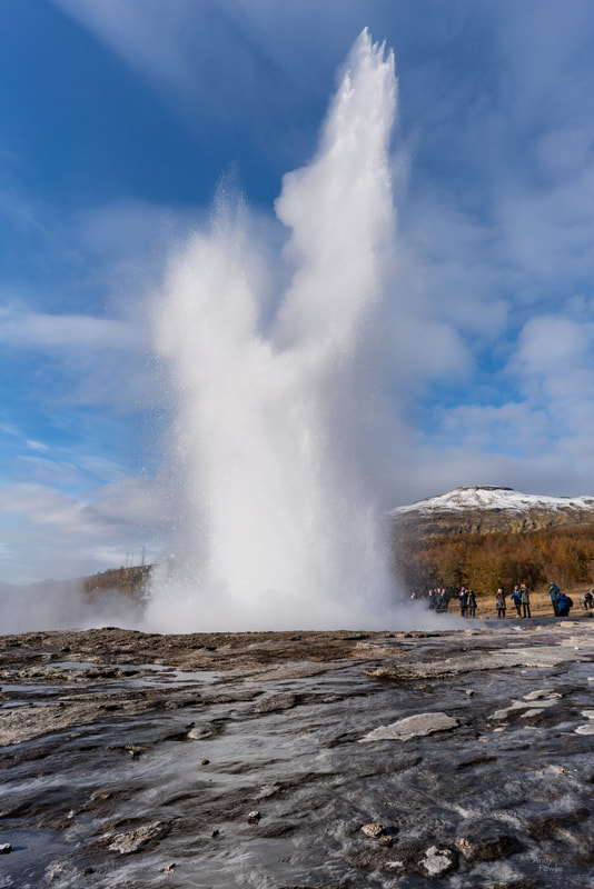 Strokkur erupts! Well, that's it for this time. Next time I will conclude my Iceland trips with a post focusing on ice. I would like to thanks all my readers for liking, sharing and commenting on my posts during this year and to wish you peace and happiness during the festive season. Andy In October I made my 3rd trip to amazing Iceland and during that trip I made multiple visits to the Stokksnes peninsula to photograph beautiful Vestrahorn. As this is one of my absolute favourite destinations I decided to give it a blog post all of its own. When flying to Iceland you will probably land at Keflavik, the main international airport, which is right on the south west corner of the country. Stokksnes on the other hand is right on the south east corner of Iceland so you need to travel just over 500 more kilometres to get your first view of the beautiful peaks of Vestrahorn. It is worth it. 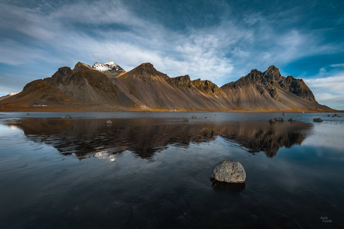 the ~450m peaks of vestrahorn, reflected in tidal mud flats Many Icelandic hot-spots receive an overwhelming number of tourists, no matter the season, and that creates a lot of challenges for photography as well as for the local environment. Vestrahorn seems to suffer slightly less from that for a few reasons.
The result is that this place has a less frantic feeling to it than many other destinations and allows you to relax into your task a bit more easily. 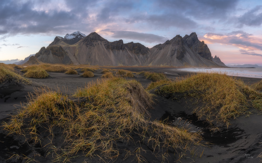 the black sand dunes, covered in wiry grasses Over the past 18 months I have been entering some online photography competitions on various different platforms, including "GuruShots" and "Photocrowd". This has sometimes been a boost for my photography as it has encouraged me to shoot more and I have also found that the results provide feedback of a sort... and in other ways it has been a distraction because all the time spent entering the competitions could instead be spent taking more pictures. One of the most positive things has been that I have got to "know" (mostly through related facebook groups) a few other photographers from all over the world who participate in the same competitions. On this trip I had the opportunity to actually meet one such friend/rival in person at Vestrahorn. Unnur Arnarsdóttir is an Icelandic landscape photographer who lives just a few kilometres away from Vestrahorn and has a number of very beautiful images from this part of the world. In my opinion her pictures from the Jökulsárlón glacier lagoon are as good as any of the many thousands of images I have seen from that famous location. I encourage all my readers to go and have a look at her pictures on flickr. Unnur's other hobby might also provide benefits for anyone who is starting to feel the bite of winter, her Etsy store contains a variety of items hand knitted from Icelandic Lopi wool. Unnur and I met at Vestrahorn in the late afternoon, hoping for interesting colours in the sky after sundown. The atmosphere of our planet did not quite perform to its full potential on this occasion but we were at least treated to some soft and gradually darkening shades of blue. After my previous visit to Vestrahorn I realised that every single one of my Vestrahorn pictures had the entire set of mountains in the frame, which seemed to be a rather limited interpretation of the possibilities. This time I tried to also find at least some compositions which did not need to include the whole mountain range. 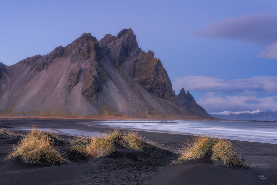 twilight at Vestrahorn The hundreds of small dunes on the black volcanic sand beach, each covered in long wispy grasses, provide many different possible foregrounds in your composition, although getting just the right arrangement of dunes in the frame is rather challenging. One thing that I worry about is whether the dunes will survive many more years of visitors, there were many areas where the banks of dunes had hundreds of footprints and the grass was getting rather trampled... without the grass roots to provide some structure and solidity to this shifting landscape it might be too easy for this environment to disappear on the wind. Searching for the perfect shot needs to be balanced against being respectful of the beautiful places that photographers like to visit. I have started to pay more attention to the potentially damaging behaviour of tourists and photographers and I have also seen some consequences as more and more areas are fenced off or obviously damaged at different locations. The role that photography plays in this is also a concern, beautiful pictures from beautiful places just encourage more and more people to visit those places and the rise of social media has just accelerated the whole cycle. If, for some reason, the tidal reflections and the grassy islands in a sea of black sand don't appeal to you, then there is still the possibility to be fascinated by the waters of the Atlantic washing relentlessly into the bay on the eastern side of the area. This is one of the more subtle and gentle beaches in Iceland allowing you to operate under the fear of getting slightly wet rather than the fear of getting slightly dead which keeps you on your toes at places such as Reynisfjara. 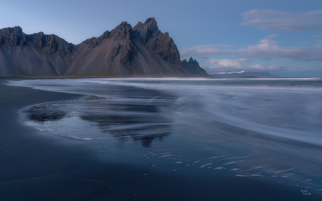 as the tide recedes There is something fascinating and hypnotic about shooting seascapes. Every wave is unique and the pattern of its arrival and departure provides a personal fingerprint of a moment that will never be repeated. A slightly longer exposure can give a sense of calm by blurring the water while also showing the patterns of movement... but with a too long exposure you can lose all sense of the dynamic action. 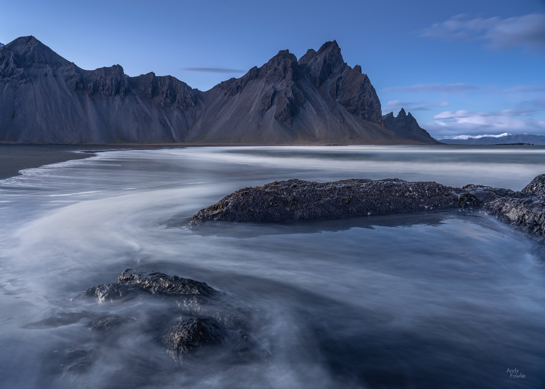 the motion of the ocean As you move further away from the mountains you come to a rocky area at the end of the beach and the ground rises to a higher plateau where an air defence radar station is situated. This radar station is one of four which jointly provide coverage of the whole of Iceland and a sizeable surrounding area. From the top of the hill you get a more panoramic view of the bay. 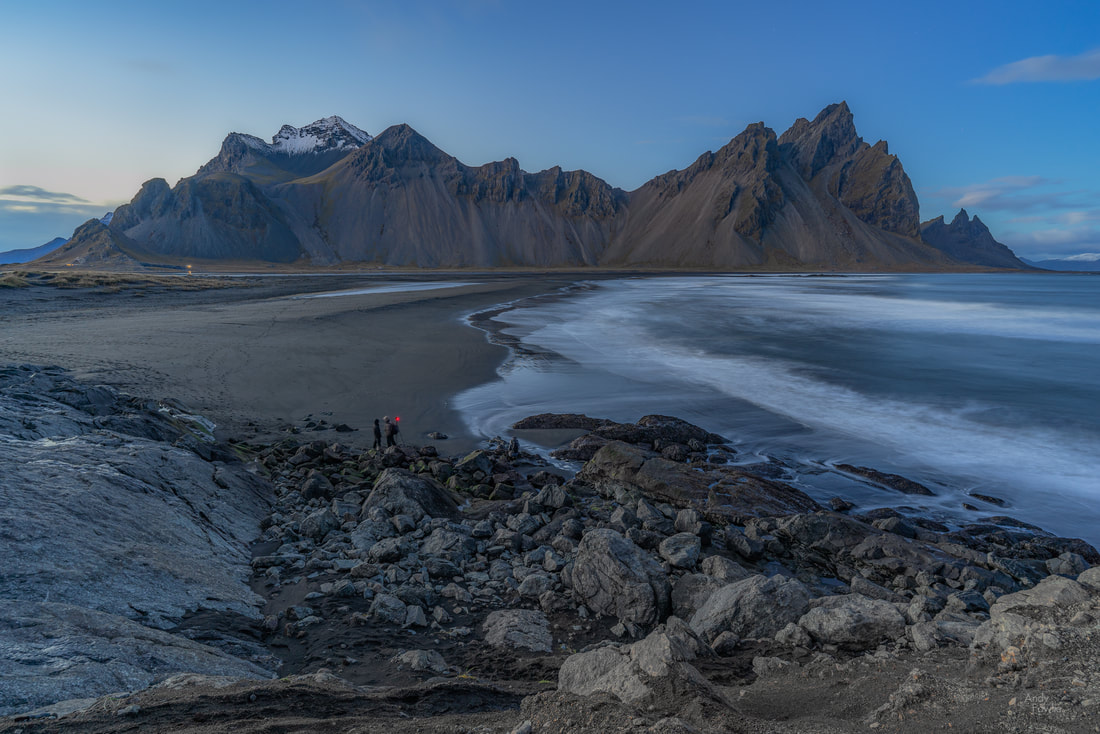 those with sharp eyes may be able to see Unnur camouflaged among the rocks, to the right of the couple whose camera has a very red light As the light faded away we went back to our cars and I talked with Unnur for a while before she headed for home. It was a great pleasure to meet her! I decided that I should go back out into the darkness and try to get a few more shots as the stars started to appear.  a night in the dunes A few hours later I was back among the dunes at Stokksnes again, waiting for the moment when the sun first hits the top of the mountain, bathing it in a warm glow while the lower parts of the scene remain in shadow. 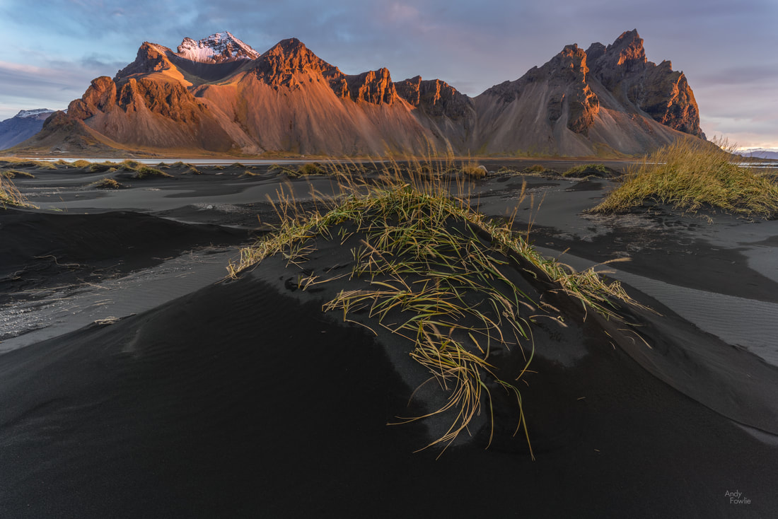 back among the dunes There were a lot of clouds on this morning, providing very interesting conditions as the sun came and went every few seconds with different parts of the scene being illumiated in turn. Mixed conditions like this sometimes offer the best opportunities for photography. 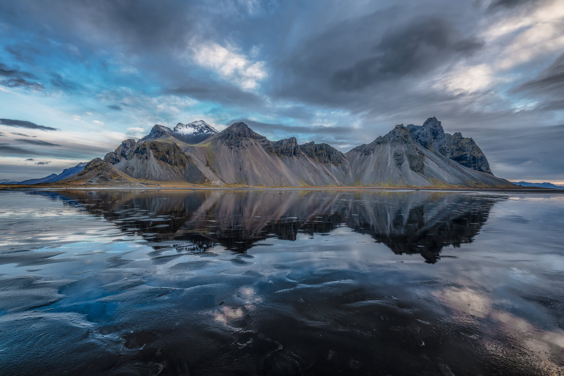 a morning on the tidal flats I required 2 cappucinos from the nearby Viking Cafe just to get acceptably awake before spending my day doing other things (stay tuned for details in upcoming posts) but I was back once again at Vestrahorn for the sunset... and this time the light was more cooperative. It started well before sunset with some lovely pink highlights in the wispy clouds. 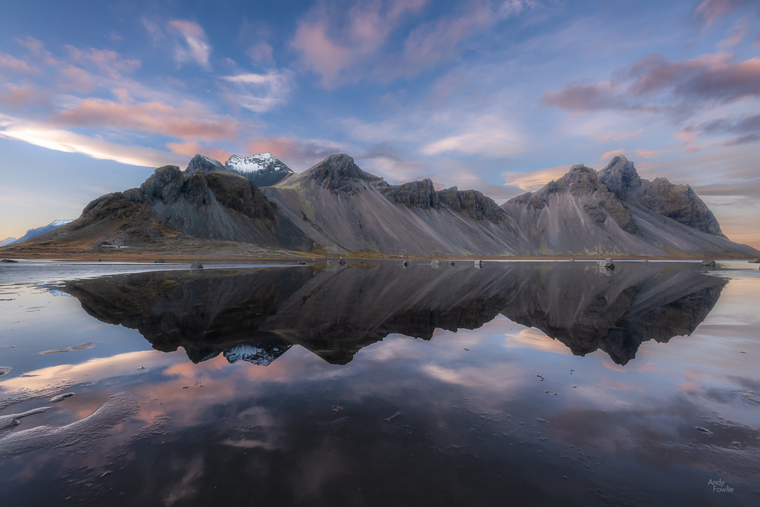 pink highlights in the sky As the sun neared the horizon I tried to catch the moment when the grassy dunes were illuminated for the last time that day. 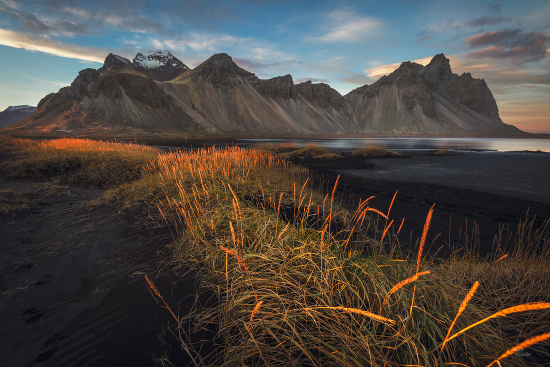 golden grasses The sun soon passed out of view below the horizon in the west and beautiful orange and pink colours intensified in the east. 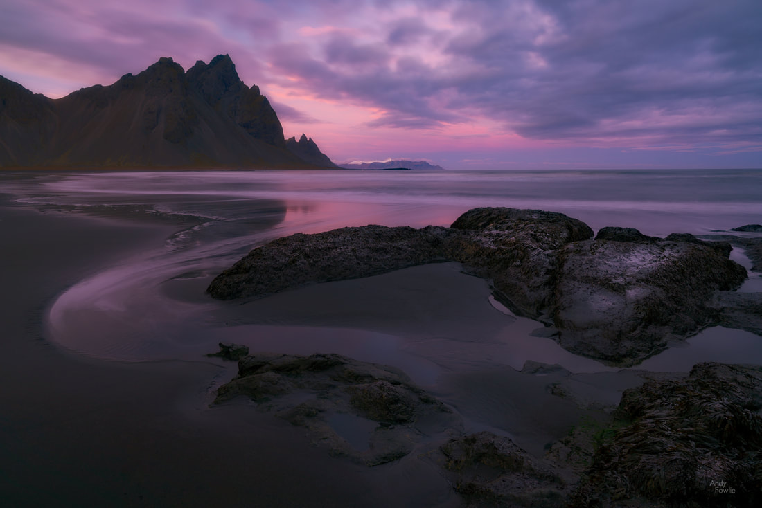 a beautiful conclusion Over the following hour the orange and pink turned into purple before finally giving way to a normal night with no trace of what had just happened. 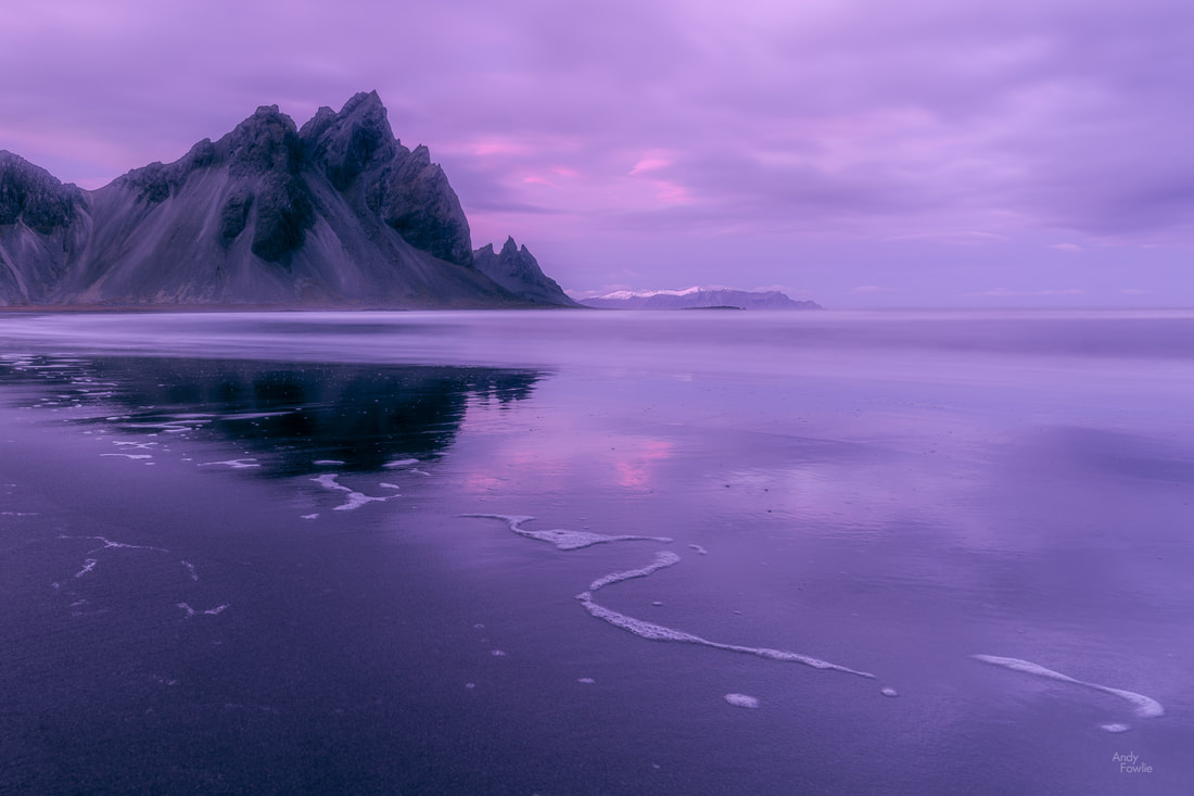 the purple hour... its a thing. I thought at the time that I was leaving Vestrahorn behind for this trip... but a couple of days later a remarkable aurora forecast (Kp 6) made me take a 3 hour detour in the late evening. I was a little late for the most active and well defined auroras, but it was still a magnificent sight. 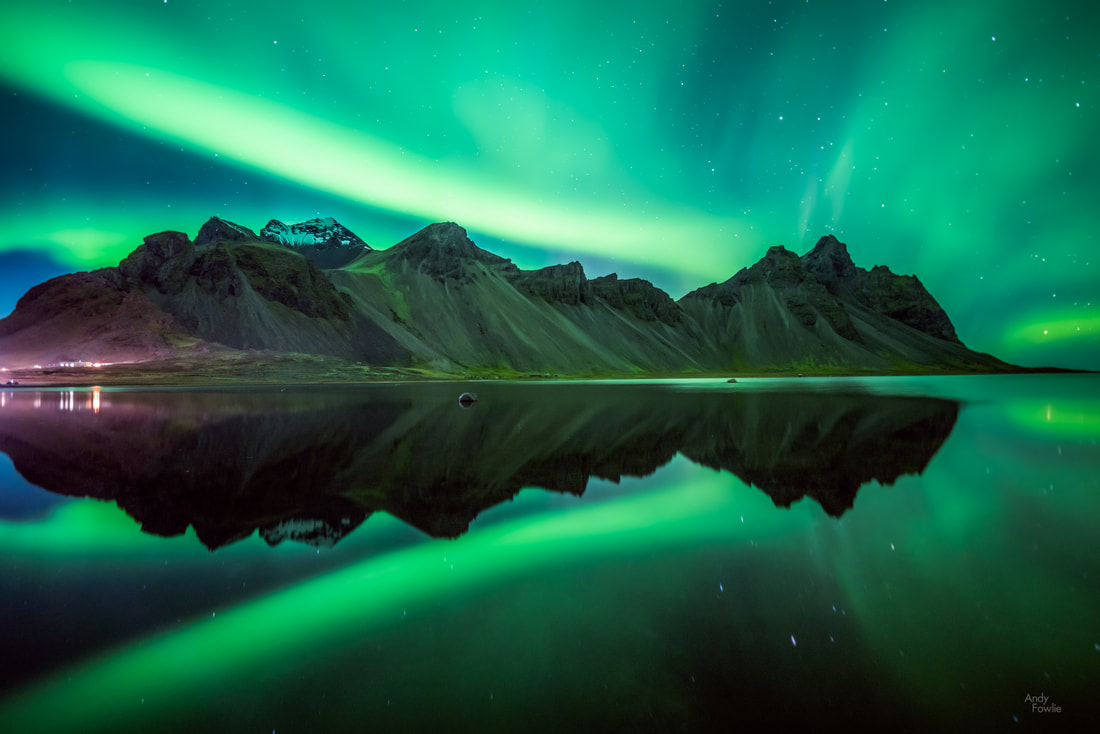 Vestrahorn auroras Well, I hope that you have enjoyed this post from Vestrahorn. You can follow my future posts by returning to this site, signing up to my mailing list (below) or by following my new photography page on Facebook. Until next time! Andy |
AuthorAndy Fowlie See also:
SubscribeEnter your email address to receive notifications of new blog posts
Archives
December 2019
Categories
All
|

- Hub
-
Portfolio
- Flow 2019
- magical Vestrahorn 2019
- Fangorn 2019
- a snowstorm at Kintail 2019
- the village 2019
- a bolt from the blue 2019
- peaceful purple pastels 2019
- a Slovenian sunrise 2019
- the cormorant 2019
- Elgol on the rocks 2019
- weeds 2019
- pretty in pink 2019
- Ritsons Force 2019
- Sakrisoy on the Rocks 2019
- the Clappersgate eye 2019
- the Falls of Falloch 2019
- in the jaws 2019
- the devils teeth 2019
- tranquility 2019
- the old man of storr 2019
- Destinations unknown
- Articles
- Recognition
- Contact
- Store
- About
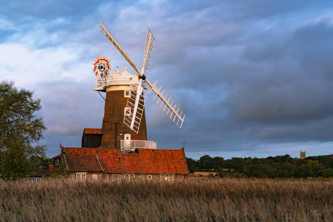
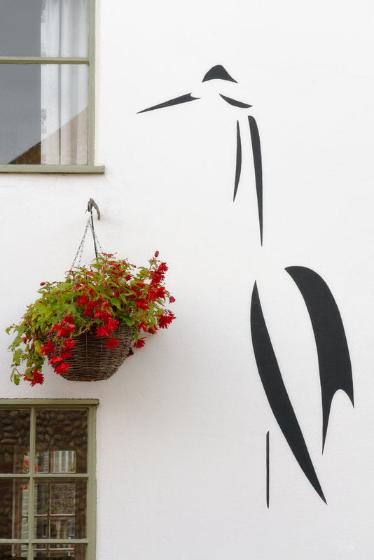
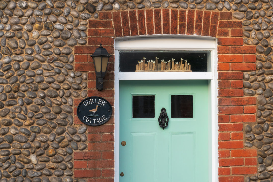
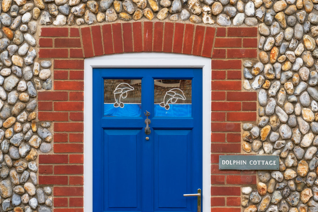
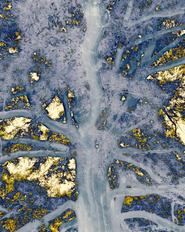
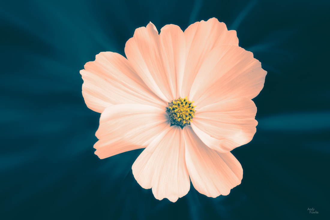
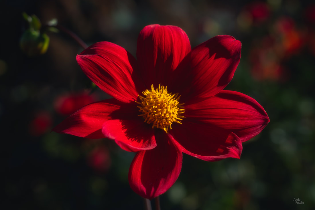
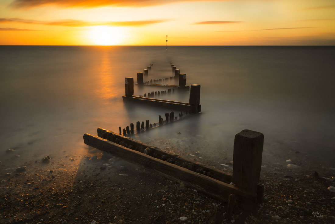
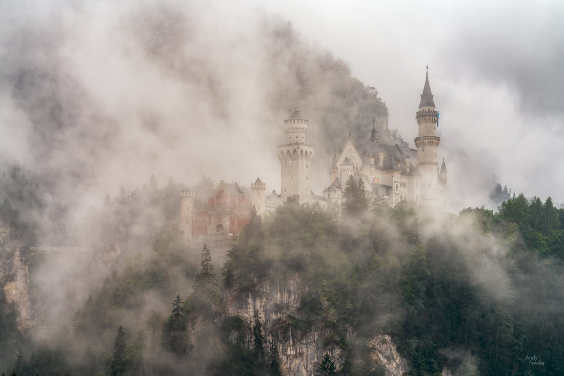

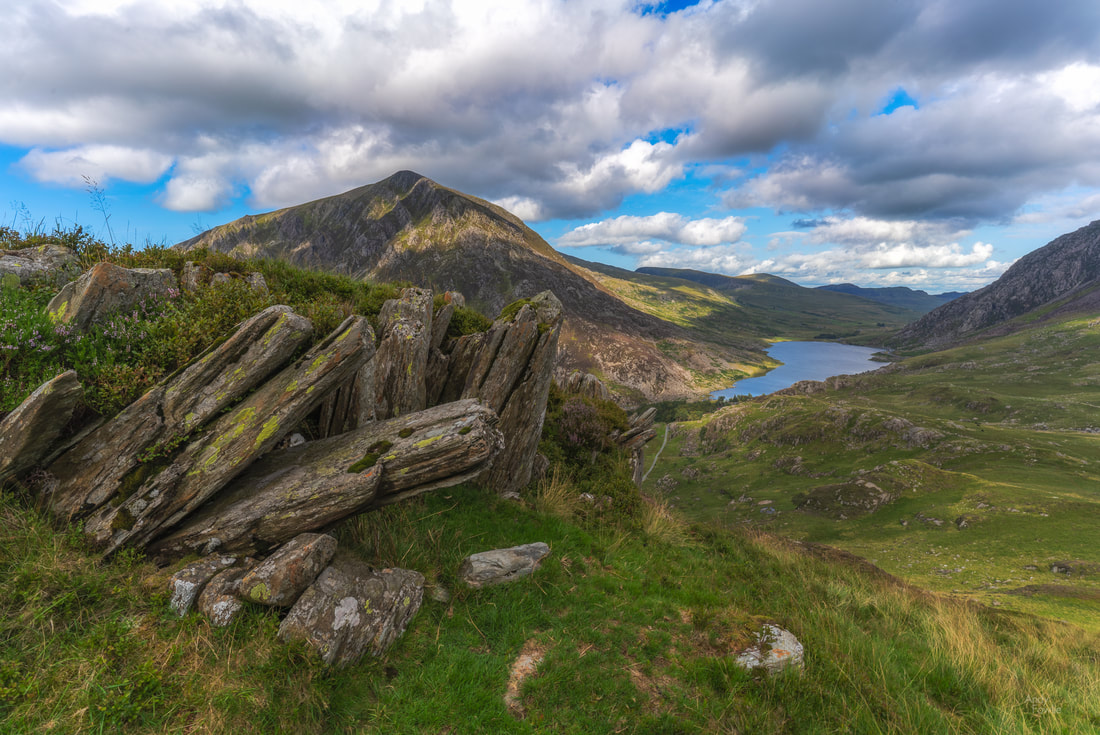
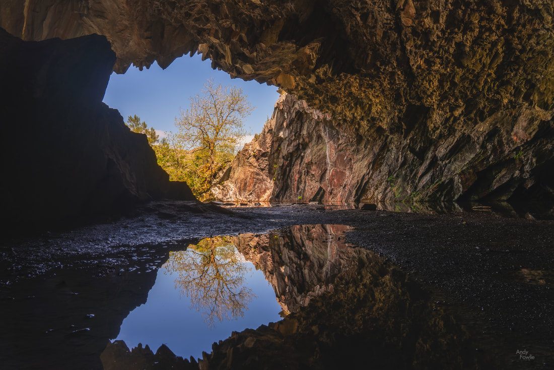


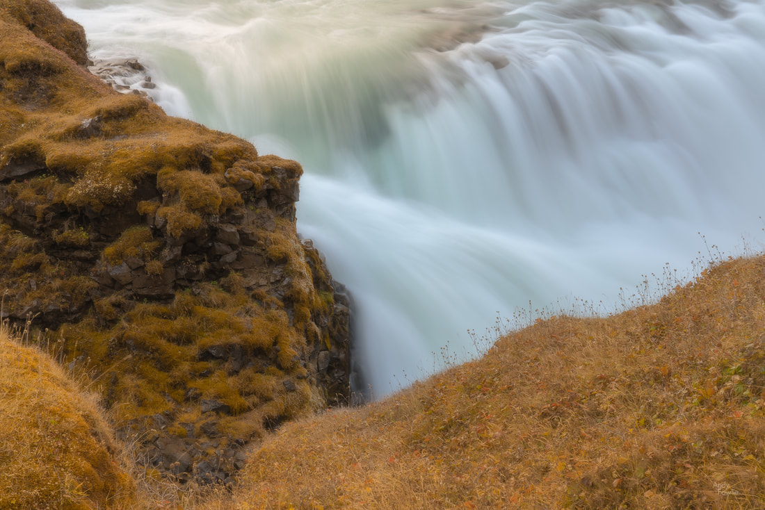
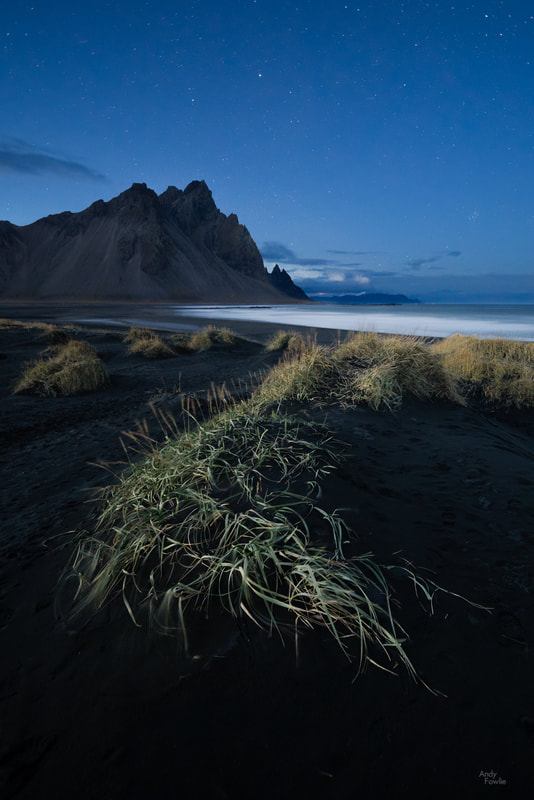
 RSS Feed
